TopoQuest Logo
Do you find TopoQuest useful?
Help keep TopoQuest running and adding new maps/features by donating!
Bitcoin:  19c7KJd3qBynnjoSw5npx9KScwjBe4ifkT
Litecoin:  LXs6TkuXGGXo1vDsWCkWVdjQX94eUKd6ui
Home View Maps Find Maps Find Places Resources & Links


Chardon, Ohio Topographic Map

USGS Map Title: Chardon, OH
USGS Map MRC: 41081E2
DRG (GeoTIFF) Download: o41081e2.tif


Neighboring USGS Topographic Map Quads:


  Mentor, OH  
41081F3
 

  Painesville, OH  
41081F2
 

  Thompson, OH  
41081F1
 

  Chesterland, OH  
41081E3
 

  Chardon, OH  
41081E2
 

  East Claridon, OH  
41081E1
 

  South Russell, OH  
41081D3
 

  Burton, OH  
41081D2
 

  Middlefield, OH  
41081D1


Map MRC Location:

N42°
W82°
N42°
W81°
H8 H7 H6 H5 H4 H3 H2 H1
G8 G7 G6 G5 G4 G3 G2 G1
F8 F7 F6 F5 F4 F3 F2 F1
E8 E7 E6 E5 E4 E3 E2 E1
D8 D7 D6 D5 D4 D3 D2 D1
C8 C7 C6 C5 C4 C3 C2 C1
B8 B7 B6 B5 B4 B3 B2 B1
A8 A7 A6 A5 A4 A3 A2 A1
N41°
W82°
N41°
W81°

Chardon, OH USGS 1:24K Topographic Map Preview:
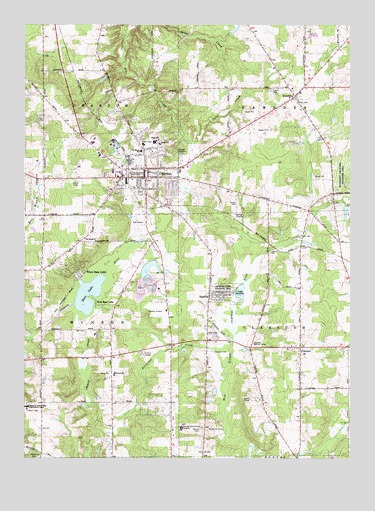
Chardon, OH USGS Topographic Map
Click on map above to begin viewing in our Map Viewer.

This topographic map contains these locations and features:
Feature Name Type Latitude Longitude GNIS ID View Map
AquillaPopulated PlaceN41.5726°W81.1543°1064337View Map
Aquilla Lake Wildlife AreaParkN41.5706°W81.1482°1037460View Map
Aquilla Village Police DepartmentBuildingN41.5467°W81.1780°2732450View Map
Ballards HillSummitN41.5898°W81.1432°1067569View Map
Bass LakeLakeN41.6003°W81.1801°1060847View Map
Beaver CreekStreamN41.5423°W81.2287°1037751View Map
Butternut CreekStreamN41.5245°W81.1718°1038578View Map
Carroll FlatsFlatN41.5556°W81.2162°1067575View Map
Center Road (historical)Populated PlaceN41.5578°W81.1284°1067576View Map
ChardonPopulated PlaceN41.6142°W81.1490°1056789View Map
Chardon Airfield (historical)AirportN41.5417°W81.2040°1082559View Map
Chardon Center CemeteryCemeteryN41.5770°W81.2054°1963330View Map
Chardon Centre (historical)Populated PlaceN41.6042°W81.2426°1057743View Map
Chardon Courthouse Square Historic DistrictParkN41.5823°W81.2034°1069139View Map
Chardon Fire DepartmentBuildingN41.5807°W81.2028°2550544View Map
Chardon High SchoolSchoolN41.5914°W81.2001°1057747View Map
Chardon Industrial ParkLocaleN41.5903°W81.2161°2546914View Map
Chardon Middle SchoolSchoolN41.5906°W81.2045°1057746View Map
Chardon Post OfficePost OfficeN41.6139°W81.1498°1988373View Map
City of ChardonCivilN41.5803°W81.2081°2397604View Map
ClaridonPopulated PlaceN41.5387°W81.1290°1060973View Map
Claridon CemeteryCemeteryN41.5308°W81.1773°1039130View Map
Claridon Center CemeteryCemeteryN41.5334°W81.1420°1963332View Map
Claridon Congregational ChurchChurchN41.5323°W81.1429°1069140View Map
Claridon Post Office (historical)Post OfficeN41.5389°W81.1290°1988333View Map
Claridon Revival CenterChurchN41.5506°W81.1520°1039131View Map
ClarksPopulated PlaceN41.5875°W81.2115°1062550View Map
County Home CemeteryCemeteryN41.5089°W81.1827°1963333View Map
Cutts CreekStreamN41.5920°W81.1890°1039554View Map
East Bass LakePopulated PlaceN41.5917°W81.1773°1048676View Map
Geauga Cinema (historical)BuildingN41.5806°W81.2042°2632543View Map
Geauga County CourthouseBuildingN41.5828°W81.2034°1069142View Map
Geauga County HomeBuildingN41.5084°W81.1787°1057745View Map
Geauga County Sheriff's OfficeBuildingN41.5047°W81.1916°2732823View Map
Grennan Mobile VillagePopulated PlaceN41.6094°W81.1822°2508947View Map
HambdenPopulated PlaceN41.6042°W81.1457°1064779View Map
Hambden Elementary SchoolSchoolN41.6053°W81.1443°1057748View Map
Hambden Fire DepartmentBuildingN41.6035°W81.1451°2550557View Map
Hambden Township CemeteryCemeteryN41.6037°W81.1440°1963337View Map
Hampden Post Office (historical)Post OfficeN41.6039°W81.1457°1988341View Map
Heather Hill HospitalHospitalN41.5357°W81.2229°2548855View Map
Jacques High Chapparal Mobile Home ParkPopulated PlaceN41.5350°W81.1778°2508938View Map
Lake AquillaLakeN41.5656°W81.1417°1060826View Map
Leader's Mobile Home ParkPopulated PlaceN41.5731°W81.1694°2508936View Map
Maple Elementary SchoolSchoolN41.6195°W81.1418°1081613View Map
Maple Hill CemeteryCemeteryN41.5003°W81.2448°1963340View Map
Maple Leaf Plaza Shopping CenterLocaleN41.5828°W81.2162°1056688View Map
Maple Ridge CommunityPopulated PlaceN41.6072°W81.1811°2508939View Map
Mayfield Road Drive-InLocaleN41.5294°W81.2047°2632542View Map
Munson Fire DepartmentBuildingN41.5384°W81.2438°2550520View Map
Munson Industrial ParkLocaleN41.5456°W81.1933°2546915View Map
Ohio State Highway Patrol - Chardon Patrol PostBuildingN41.5926°W81.2273°2732865View Map
Parker Court Industrial ParkLocaleN41.5836°W81.2297°2546913View Map
Peace ChurchChurchN41.5242°W81.2176°1044339View Map
Pitkin CemeteryCemeteryN41.6245°W81.1454°1044511View Map
Pleasant Hill Golf CourseLocaleN41.5017°W81.1809°1057744View Map
Saint Lukes ChurchChurchN41.6137°W81.1704°1045616View Map
Saint Marys SchoolSchoolN41.6223°W81.1468°1045696View Map
Terrace Glenn EstatesPopulated PlaceN41.6050°W81.1556°2508943View Map
Township of ChardonCivilN41.6090°W81.2483°1086150View Map
Township of ClaridonCivilN41.5360°W81.1452°1086152View Map
Township of HambdenCivilN41.6063°W81.1458°1086153View Map
Township of MunsonCivilN41.5340°W81.2449°1086157View Map
University Hospitals Geauga Medical CenterHospitalN41.5088°W81.1896°2548832View Map
Village of AquillaCivilN41.5465°W81.1731°2397975View Map
WCDN-AM (Chardon)TowerN41.5676°W81.1923°1083695View Map
West Bass LakePopulated PlaceN41.6056°W81.1779°1056957View Map
Wooddin HillSummitN41.6128°W81.1537°1067580View Map

Note: Coordinates in the location and feature list above are referenced to NAD83 datum.


Copyright (C) 2008-2025 Ryan Niemi / Sunset Dynamics ... All Rights Reserved