TopoQuest Logo
Do you find TopoQuest useful?
Help keep TopoQuest running and adding new maps/features by donating!
Bitcoin:  19c7KJd3qBynnjoSw5npx9KScwjBe4ifkT
Litecoin:  LXs6TkuXGGXo1vDsWCkWVdjQX94eUKd6ui
Home View Maps Find Maps Find Places Resources & Links


Walnut Lake, Mississippi Topographic Map

USGS Map Title: Walnut Lake, MS
USGS Map MRC: 34090E3
DRG (GeoTIFF) Download: o34090e3.tif


Neighboring USGS Topographic Map Quads:


  Tunica, MS  
34090F4
 

  Hollywood, MS  
34090F3
 

  Arkabutla West, MS  
34090F2
 

  Dundee, MS  
34090E4
 

  Walnut Lake, MS  
34090E3
 

  Crenshaw North, MS  
34090E2
 

  Lula, MS  
34090D4
 

  Falcon, MS  
34090D3
 

  Crenshaw South, MS  
34090D2


Map MRC Location:

N35°
W91°
N35°
W90°
H8 H7 H6 H5 H4 H3 H2 H1
G8 G7 G6 G5 G4 G3 G2 G1
F8 F7 F6 F5 F4 F3 F2 F1
E8 E7 E6 E5 E4 E3 E2 E1
D8 D7 D6 D5 D4 D3 D2 D1
C8 C7 C6 C5 C4 C3 C2 C1
B8 B7 B6 B5 B4 B3 B2 B1
A8 A7 A6 A5 A4 A3 A2 A1
N34°
W91°
N34°
W90°

Walnut Lake, MS USGS 1:24K Topographic Map Preview:
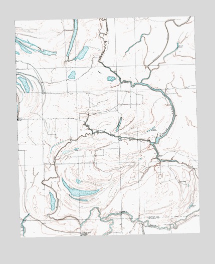
Walnut Lake, MS USGS Topographic Map
Click on map above to begin viewing in our Map Viewer.

This topographic map contains these locations and features:
Feature Name Type Latitude Longitude GNIS ID View Map
Antioch ChurchChurchN34.5832°W90.3554°666332View Map
Berea CemeteryCemeteryN34.5123°W90.3659°666840View Map
Berea ChurchChurchN34.5123°W90.3659°666842View Map
Bethany CemeteryCemeteryN34.6026°W90.3393°666860View Map
Bethany ChurchChurchN34.6026°W90.3393°666874View Map
Bonnie Blue SchoolSchoolN34.5982°W90.3748°667430View Map
Brushy BayouGutN34.5593°W90.3126°667674View Map
Cannon SchoolSchoolN34.5540°W90.2895°668049View Map
Church of God CemeteryCemeteryN34.5470°W90.3573°668478View Map
Clear LakeLakeN34.5665°W90.3265°668582View Map
Daygo CemeteryCemeteryN34.5676°W90.3443°684840View Map
Dooley Wood CemeteryCemeteryN34.5462°W90.3212°684842View Map
Dooley Wood SchoolSchoolN34.5395°W90.3070°669329View Map
DubbsPopulated PlaceN34.5684°W90.3737°669464View Map
Dubbs SchoolSchoolN34.5679°W90.3515°684844View Map
East Dubbs ChurchChurchN34.5470°W90.3573°668479View Map
Flag LakeLakeN34.5509°W90.3342°670013View Map
Gerlach MillPopulated PlaceN34.5029°W90.3329°691881View Map
Gum PondSwampN34.5304°W90.2707°670796View Map
HallyPopulated PlaceN34.5090°W90.3620°684848View Map
Hatch LakeLakeN34.6083°W90.2622°671003View Map
Jehovan Rest ChurchChurchN34.5679°W90.3534°671829View Map
Lake TyranzaLakeN34.5610°W90.2812°679018View Map
Macedonia ChurchChurchN34.5551°W90.2895°673030View Map
McNeil ChurchChurchN34.5029°W90.2895°673417View Map
New Baptist CemeteryCemeteryN34.5790°W90.2718°674566View Map
New Baptist ChurchChurchN34.5790°W90.2718°674567View Map
Paul Battles Catfish Ponds DamDamN34.6051°W90.2834°682734View Map
Paul Battles Catfish Ponds DamDamN34.6184°W90.3318°682738View Map
Paul Battles Catfish Ponds DamDamN34.6234°W90.2968°682743View Map
Phillips CemeteryCemeteryN34.5570°W90.3054°675686View Map
Phillips ChurchChurchN34.5570°W90.3054°675688View Map
PinkPopulated PlaceN34.5557°W90.3045°684867View Map
Pruett SchoolSchoolN34.5684°W90.3359°676404View Map
Seven Mile BayouStreamN34.5882°W90.2884°677522View Map
Souva LakeLakeN34.5163°W90.2556°678029View Map
Thompson SchoolSchoolN34.5379°W90.3568°678717View Map
Trout LakeLakeN34.5639°W90.3038°684876View Map
Twomile LakeLakeN34.5063°W90.3727°679015View Map
Walnut LakeLakeN34.5662°W90.2665°679305View Map
White Oak BayouStreamN34.5098°W90.3182°679629View Map
Whites CemeteryCemeteryN34.5979°W90.3737°679633View Map
Whites ChurchChurchN34.5979°W90.3737°679637View Map

Note: Coordinates in the location and feature list above are referenced to NAD83 datum.


Copyright (C) 2008-2025 Ryan Niemi / Sunset Dynamics ... All Rights Reserved