TopoQuest Logo
Do you find TopoQuest useful?
Help keep TopoQuest running and adding new maps/features by donating!
Bitcoin:  19c7KJd3qBynnjoSw5npx9KScwjBe4ifkT
Litecoin:  LXs6TkuXGGXo1vDsWCkWVdjQX94eUKd6ui
Home View Maps Find Maps Find Places Resources & Links


Arkabutla West, Mississippi Topographic Map

USGS Map Title: Arkabutla West, MS
USGS Map MRC: 34090F2
DRG (GeoTIFF) Download: o34090f2.tif


Neighboring USGS Topographic Map Quads:


  Robinsonville, MS  
34090G3
 

  Banks, MS  
34090G2
 

  Frees Corners, MS  
34090G1
 

  Hollywood, MS  
34090F3
 

  Arkabutla West, MS  
34090F2
 

  Arkabutla East, MS  
34090F1
 

  Walnut Lake, MS  
34090E3
 

  Crenshaw North, MS  
34090E2
 

  Longtown, MS  
34090E1


Map MRC Location:

N35°
W91°
N35°
W90°
H8 H7 H6 H5 H4 H3 H2 H1
G8 G7 G6 G5 G4 G3 G2 G1
F8 F7 F6 F5 F4 F3 F2 F1
E8 E7 E6 E5 E4 E3 E2 E1
D8 D7 D6 D5 D4 D3 D2 D1
C8 C7 C6 C5 C4 C3 C2 C1
B8 B7 B6 B5 B4 B3 B2 B1
A8 A7 A6 A5 A4 A3 A2 A1
N34°
W91°
N34°
W90°

Arkabutla West, MS USGS 1:24K Topographic Map Preview:
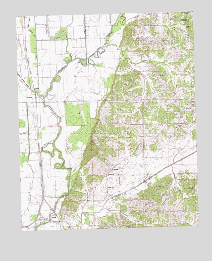
Arkabutla West, MS USGS Topographic Map
Click on map above to begin viewing in our Map Viewer.

This topographic map contains these locations and features:
Feature Name Type Latitude Longitude GNIS ID View Map
Arkabutla CemeteryCemeteryN34.6845°W90.1376°666363View Map
Arkabutla Consolidated High School (historical)SchoolN34.6932°W90.1284°705988View Map
Arkabutla Fire DepartmentBuildingN34.6592°W90.1850°2665947View Map
Big BayouStreamN34.6576°W90.2140°667072View Map
Bill McLean Pond DamDamN34.6801°W90.1251°682773View Map
Blue Hill ChurchChurchN34.7137°W90.1501°667288View Map
Caney CreekStreamN34.6365°W90.1929°668037View Map
Center Hill ChurchChurchN34.6393°W90.1559°668241View Map
Church of ChristChurchN34.7115°W90.1676°668450View Map
CottonvillePopulated PlaceN34.6595°W90.1848°683411View Map
Cub Lake BayouStreamN34.7440°W90.1826°690261View Map
Dalehite LakeLakeN34.6692°W90.2130°683414View Map
District One Volunteer Fire Department Station 2BuildingN34.6415°W90.1625°2665915View Map
Ditch Number EightCanalN34.7198°W90.2357°669284View Map
DooleyPopulated PlaceN34.6707°W90.2370°691822View Map
E L Herron Pond DamDamN34.6351°W90.1368°682749View Map
Ella Green School (historical)SchoolN34.7412°W90.1301°1805838View Map
EvansvillePopulated PlaceN34.6270°W90.2159°683422View Map
Evansville ChurchChurchN34.6493°W90.1881°669838View Map
Flat BayouGutN34.6543°W90.2407°670017View Map
Forrest TowerLocaleN34.6748°W90.1962°670106View Map
Green ChurchChurchN34.7418°W90.1295°669726View Map
Holly BranchStreamN34.7434°W90.1801°671305View Map
Hudsons Ferry (historical)CrossingN34.6307°W90.2307°684849View Map
Lake Cormorant BayouStreamN34.7237°W90.2115°690321View Map
Long LakeLakeN34.6790°W90.2145°683441View Map
Lost Lake BayouStreamN34.7232°W90.2126°672881View Map
Mid-South CollegeSchoolN34.6473°W90.1290°683449View Map
Mosquito LakeLakeN34.6643°W90.2140°683451View Map
Mud LakeLakeN34.6823°W90.2120°683454View Map
Northwest AcademySchoolN34.6934°W90.1281°706006View Map
Powell School (historical)SchoolN34.6754°W90.1534°1805843View Map
PrichardPopulated PlaceN34.6995°W90.2443°692158View Map
Rock CreekStreamN34.7312°W90.1865°676748View Map
Round LakeLakeN34.6718°W90.2165°683464View Map
Saint Maryland ChurchChurchN34.6565°W90.1895°677146View Map
SavagePopulated PlaceN34.6298°W90.2232°692212View Map
Smith Chapel (historical)ChurchN34.7315°W90.1548°1805846View Map
South Abutment Public Use AreaParkN34.7459°W90.1306°683474View Map
Sturdy School (historical)SchoolN34.7034°W90.1684°1805848View Map
Tee BayouGutN34.6829°W90.2445°678614View Map
The Shepard ChurchChurchN34.7070°W90.2395°678668View Map
Thompsons Ferry (historical)CrossingN34.6995°W90.2318°684875View Map

Note: Coordinates in the location and feature list above are referenced to NAD83 datum.


Copyright (C) 2008-2025 Ryan Niemi / Sunset Dynamics ... All Rights Reserved