TopoQuest Logo
Do you find TopoQuest useful?
Help keep TopoQuest running and adding new maps/features by donating!
Bitcoin:  19c7KJd3qBynnjoSw5npx9KScwjBe4ifkT
Litecoin:  LXs6TkuXGGXo1vDsWCkWVdjQX94eUKd6ui
Home View Maps Find Maps Find Places Resources & Links


Crenshaw North, Mississippi Topographic Map

USGS Map Title: Crenshaw North, MS
USGS Map MRC: 34090E2
DRG (GeoTIFF) Download: o34090e2.tif


Neighboring USGS Topographic Map Quads:


  Hollywood, MS  
34090F3
 

  Arkabutla West, MS  
34090F2
 

  Arkabutla East, MS  
34090F1
 

  Walnut Lake, MS  
34090E3
 

  Crenshaw North, MS  
34090E2
 

  Longtown, MS  
34090E1
 

  Falcon, MS  
34090D3
 

  Crenshaw South, MS  
34090D2
 

  Pleasant Grove, MS  
34090D1


Map MRC Location:

N35°
W91°
N35°
W90°
H8 H7 H6 H5 H4 H3 H2 H1
G8 G7 G6 G5 G4 G3 G2 G1
F8 F7 F6 F5 F4 F3 F2 F1
E8 E7 E6 E5 E4 E3 E2 E1
D8 D7 D6 D5 D4 D3 D2 D1
C8 C7 C6 C5 C4 C3 C2 C1
B8 B7 B6 B5 B4 B3 B2 B1
A8 A7 A6 A5 A4 A3 A2 A1
N34°
W91°
N34°
W90°

Crenshaw North, MS USGS 1:24K Topographic Map Preview:
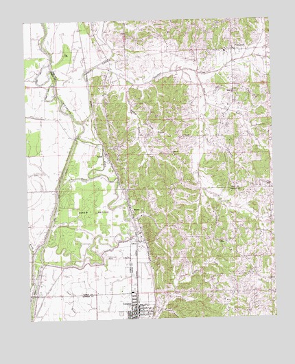
Crenshaw North, MS USGS Topographic Map
Click on map above to begin viewing in our Map Viewer.

This topographic map contains these locations and features:
Feature Name Type Latitude Longitude GNIS ID View Map
Arkabutla CreekStreamN34.5829°W90.2209°666364View Map
AskewPopulated PlaceN34.5370°W90.1934°666404View Map
Askew RefugeParkN34.5432°W90.2168°684828View Map
Big Dog BayouStreamN34.6162°W90.2420°667112View Map
Browns Ferry (historical)CrossingN34.5712°W90.2112°684833View Map
Brushy BayouStreamN34.5165°W90.2487°667679View Map
BuxtonPopulated PlaceN34.5479°W90.1979°691742View Map
Coleman School (historical)SchoolN34.5190°W90.1404°1805830View Map
Coon BayouGutN34.5593°W90.2245°684835View Map
Coon Bayou Cut-OffCanalN34.5595°W90.2323°668794View Map
CrenshawPopulated PlaceN34.5026°W90.1987°668941View Map
Crenshaw Elementary SchoolSchoolN34.5009°W90.1976°707413View Map
Crenshaw Police DepartmentBuildingN34.5048°W90.1953°2754179View Map
Crenshaw Post OfficePost OfficeN34.5051°W90.1949°2768754View Map
Egypt CreekStreamN34.6034°W90.1640°669701View Map
Egypt CreekStreamN34.6034°W90.1634°669702View Map
Flag LakeLakeN34.6107°W90.2301°670014View Map
GoodePopulated PlaceN34.5762°W90.1709°683425View Map
Harmony CemeteryCemeteryN34.5804°W90.1290°670932View Map
Harold Meek Pond DamDamN34.5868°W90.1668°682726View Map
Indian Creek Watershed Y-19a-20 DamDamN34.5268°W90.1751°682691View Map
Indian Creek Watershed Y-9a-17 DamDamN34.5201°W90.1618°682686View Map
Indian Creek Watershed Y-9a-21 DamDamN34.5051°W90.1784°682679View Map
Indian Creek Watershed Y-9a-7 DamDamN34.5034°W90.1801°682677View Map
Indian Creek Watershed Y-9a-8 DamDamN34.5084°W90.1718°682680View Map
J O Stuart Pond DamDamN34.5918°W90.1668°682729View Map
Kirksey CreekStreamN34.5071°W90.1793°672190View Map
KJirkseyPopulated PlaceN34.5123°W90.1754°692353View Map
Lambert ChapelChurchN34.5559°W90.1301°672282View Map
Lambert School (historical)SchoolN34.5634°W90.1315°1805842View Map
Matthews Ferry (historical)CrossingN34.5912°W90.2312°684858View Map
Mississippi No Name 217 DamDamN34.5618°W90.1784°682709View Map
Mrs Francis Fulkson Pond DamDamN34.5968°W90.1318°682732View Map
Nelson BranchStreamN34.5040°W90.1837°674549View Map
Patent CreekStreamN34.6090°W90.1270°675490View Map
Porter and Blankenships Store (historical)LocaleN34.5298°W90.1515°685726View Map
Rader CreekStreamN34.5904°W90.1581°676452View Map
Riverside SchoolSchoolN34.5845°W90.2379°676687View Map
Saint Mary ChurchChurchN34.5257°W90.1995°677145View Map
Sanders BranchStreamN34.5987°W90.1954°677354View Map
Sandy BranchStreamN34.5823°W90.1918°677377View Map
SarahPopulated PlaceN34.5695°W90.2104°677408View Map
Sarah Post OfficePost OfficeN34.5544°W90.2010°2768782View Map
Sees ChapelChurchN34.5323°W90.1531°677499View Map
Spring Hill ChurchChurchN34.5957°W90.1451°678141View Map
Spring Hill School (historical)SchoolN34.5954°W90.1445°1805847View Map
StrayhornPopulated PlaceN34.6123°W90.1440°678346View Map
Strayhorn Baptist ChurchChurchN34.6129°W90.1434°706012View Map
Strayhorn CreekStreamN34.6059°W90.2140°678347View Map
Strayhorn Elementary SchoolSchoolN34.6120°W90.1484°706013View Map
Town of CrenshawCivilN34.5047°W90.1946°2406335View Map
Trinity ChurchChurchN34.5118°W90.1759°678888View Map
Truslow ChurchChurchN34.5695°W90.1770°678908View Map
Whitsells Box (historical)LocaleN34.6079°W90.1409°683488View Map
Yellow Lake BayouSwampN34.5257°W90.2107°679947View Map

Note: Coordinates in the location and feature list above are referenced to NAD83 datum.


Copyright (C) 2008-2025 Ryan Niemi / Sunset Dynamics ... All Rights Reserved