TopoQuest Logo
Do you find TopoQuest useful?
Help keep TopoQuest running and adding new maps/features by donating!
Bitcoin:  19c7KJd3qBynnjoSw5npx9KScwjBe4ifkT
Litecoin:  LXs6TkuXGGXo1vDsWCkWVdjQX94eUKd6ui
Home View Maps Find Maps Find Places Resources & Links


Waverly Hall, Georgia Topographic Map

USGS Map Title: Waverly Hall, GA
USGS Map MRC: 32084F6
DRG (GeoTIFF) Download: o32084f6.tif


Neighboring USGS Topographic Map Quads:


  Pine Mountain, GA  
32084G7
 

  Shiloh, GA  
32084G6
 

  Manchester, GA  
32084G5
 

  Cataula, GA  
32084F7
 

  Waverly Hall, GA  
32084F6
 

  Talbotton, GA  
32084F5
 

  Midland, GA  
32084E7
 

  Upatoi, GA  
32084E6
 

  Geneva, GA  
32084E5


Map MRC Location:

N33°
W85°
N33°
W84°
H8 H7 H6 H5 H4 H3 H2 H1
G8 G7 G6 G5 G4 G3 G2 G1
F8 F7 F6 F5 F4 F3 F2 F1
E8 E7 E6 E5 E4 E3 E2 E1
D8 D7 D6 D5 D4 D3 D2 D1
C8 C7 C6 C5 C4 C3 C2 C1
B8 B7 B6 B5 B4 B3 B2 B1
A8 A7 A6 A5 A4 A3 A2 A1
N32°
W85°
N32°
W84°

Waverly Hall, GA USGS 1:24K Topographic Map Preview:
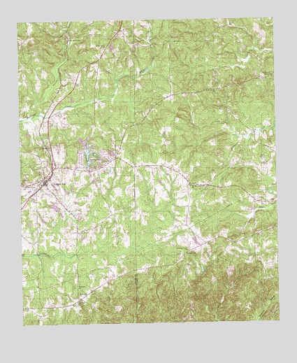
Waverly Hall, GA USGS Topographic Map
Click on map above to begin viewing in our Map Viewer.

This topographic map contains these locations and features:
Feature Name Type Latitude Longitude GNIS ID View Map
BaughvillePopulated PlaceN32.6529°W84.6705°331105View Map
Bluff Spring ChurchChurchN32.7215°W84.6538°354795View Map
Favors DamDamN32.7385°W84.7049°340280View Map
Favors LakeReservoirN32.7394°W84.7041°340281View Map
Flatrock ChurchChurchN32.6401°W84.7227°314208View Map
Humble Zion ChurchChurchN32.6551°W84.6691°315813View Map
Laney SchoolSchoolN32.6835°W84.7494°316627View Map
Long LakeReservoirN32.6955°W84.7051°340494View Map
Long Lake DamDamN32.6968°W84.7066°340493View Map
Mathews ChapelChurchN32.7274°W84.6263°317785View Map
Melody Lake Volunteer Fire DepartmentBuildingN32.6968°W84.7150°2604466View Map
Mount McCatherine ChurchChurchN32.6821°W84.6660°318687View Map
Mount Zion Church (historical)ChurchN32.6921°W84.6999°350827View Map
Oak MountainPopulated PlaceN32.7426°W84.7252°326432View Map
Peeds LakesReservoirN32.6955°W84.7169°320334View Map
Pine Grove ChurchChurchN32.7393°W84.7063°320572View Map
Pitts Memorial ChurchChurchN32.6826°W84.7480°320776View Map
RidgewayPopulated PlaceN32.6354°W84.7216°326489View Map
Ridgeway CemeteryCemeteryN32.6327°W84.7240°321596View Map
Rockcola ChurchChurchN32.6368°W84.7221°321763View Map
Saint Johns CemeteryCemeteryN32.7026°W84.7358°322100View Map
Silver LakeReservoirN32.6931°W84.7099°340496View Map
Silver Lake DamDamN32.6918°W84.7099°340495View Map
Ski LakeReservoirN32.7004°W84.7184°338467View Map
Ski Lake DamDamN32.7001°W84.7216°338466View Map
Sparks CreekStreamN32.7118°W84.7408°323329View Map
Springfield ChurchChurchN32.6974°W84.7352°323463View Map
Storey DamDamN32.6718°W84.7316°338438View Map
Storey LakeReservoirN32.6736°W84.7335°338439View Map
Town of Waverly HallCivilN32.6837°W84.7378°2406843View Map
Waverly HallPopulated PlaceN32.6835°W84.7383°333376View Map
Waverly Hall CemeteryCemeteryN32.6893°W84.7144°324930View Map
Waverly Hall Elementary SchoolSchoolN32.6849°W84.7355°351005View Map
Waverly Hall Police DepartmentBuildingN32.6850°W84.7355°2733736View Map
Waverly Hall Volunteer Fire DepartmentBuildingN32.6825°W84.7396°2603839View Map
Waverly LandingAirportN32.7144°W84.7181°2625409View Map
Whispering Pines LakeReservoirN32.6955°W84.7169°338451View Map
Whispering Pines Lake DamDamN32.6968°W84.7166°338450View Map

Note: Coordinates in the location and feature list above are referenced to NAD83 datum.


Copyright (C) 2008-2024 Ryan Niemi / Sunset Dynamics ... All Rights Reserved