TopoQuest Logo
Do you find TopoQuest useful?
Help keep TopoQuest running and adding new maps/features by donating!
Bitcoin:  19c7KJd3qBynnjoSw5npx9KScwjBe4ifkT
Litecoin:  LXs6TkuXGGXo1vDsWCkWVdjQX94eUKd6ui
Home View Maps Find Maps Find Places Resources & Links


Upatoi, Georgia Topographic Map

USGS Map Title: Upatoi, GA
USGS Map MRC: 32084E6
DRG (GeoTIFF) Download: o32084e6.tif


Neighboring USGS Topographic Map Quads:


  Cataula, GA  
32084F7
 

  Waverly Hall, GA  
32084F6
 

  Talbotton, GA  
32084F5
 

  Midland, GA  
32084E7
 

  Upatoi, GA  
32084E6
 

  Geneva, GA  
32084E5
 

  Ochillee, GA  
32084D7
 

  Buena Vista NW, GA  
32084D6
 

  Buena Vista NE, GA  
32084D5


Map MRC Location:

N33°
W85°
N33°
W84°
H8 H7 H6 H5 H4 H3 H2 H1
G8 G7 G6 G5 G4 G3 G2 G1
F8 F7 F6 F5 F4 F3 F2 F1
E8 E7 E6 E5 E4 E3 E2 E1
D8 D7 D6 D5 D4 D3 D2 D1
C8 C7 C6 C5 C4 C3 C2 C1
B8 B7 B6 B5 B4 B3 B2 B1
A8 A7 A6 A5 A4 A3 A2 A1
N32°
W85°
N32°
W84°

Upatoi, GA USGS 1:24K Topographic Map Preview:
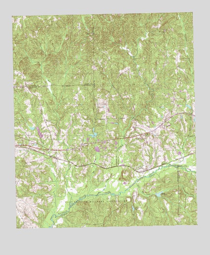
Upatoi, GA USGS Topographic Map
Click on map above to begin viewing in our Map Viewer.

This topographic map contains these locations and features:
Feature Name Type Latitude Longitude GNIS ID View Map
Baker CreekStreamN32.5188°W84.6941°310742View Map
Box SpringsPopulated PlaceN32.5326°W84.6610°354828View Map
Box Springs ChurchChurchN32.5510°W84.6535°350806View Map
Box Springs Methodist ChurchChurchN32.5335°W84.6594°350807View Map
Box Springs Post OfficePost OfficeN32.5604°W84.6471°350808View Map
Boyd BranchStreamN32.5735°W84.7196°311686View Map
Columbus Fire and Emergency Medical Services Station 15BuildingN32.5498°W84.7250°2604506View Map
County Line ChurchChurchN32.5463°W84.7041°313032View Map
Cox CreekStreamN32.5079°W84.7244°313072View Map
Cox DamDamN32.5551°W84.7299°340070View Map
Cox LakeReservoirN32.5563°W84.7327°340071View Map
Crossroads SchoolSchoolN32.5482°W84.7041°313179View Map
Hollis CemeteryCemeteryN32.6051°W84.6444°350818View Map
Kendall CreekStreamN32.5129°W84.7124°356340View Map
Kings Mill (historical)LocaleN32.5196°W84.6530°351040View Map
Kings Mill CreekStreamN32.5257°W84.6671°316455View Map
Kings MillpondReservoirN32.5188°W84.6511°316457View Map
Liberty Hill Baptist Church (historical)ChurchN32.5674°W84.6416°350823View Map
Liberty Hill CemeteryCemeteryN32.5676°W84.6416°316829View Map
Little Juniper CreekStreamN32.5201°W84.6488°317106View Map
McClure LakeReservoirN32.5540°W84.6965°340536View Map
McClure Lake DamDamN32.5535°W84.6966°340535View Map
Mobleys PondReservoirN32.5107°W84.6692°318371View Map
Montarella LakeReservoirN32.5445°W84.6929°340538View Map
Montarella Lake DamDamN32.5435°W84.6933°340537View Map
Mount Carmel ChurchChurchN32.6146°W84.6446°318602View Map
Mount Paron ChurchChurchN32.5532°W84.6585°318798View Map
Mount Pilgrim ChurchChurchN32.5574°W84.6466°318807View Map
Phillips CemeteryCemeteryN32.5521°W84.7244°320457View Map
Pine Grove Academy (historical)SchoolN32.5535°W84.6588°350833View Map
Riley BranchStreamN32.5638°W84.6680°321609View Map
Rockmore CreekStreamN32.5518°W84.6305°321776View Map
Scroggins BranchStreamN32.5357°W84.6410°322663View Map
Sweet Home ChurchChurchN32.5513°W84.6605°323813View Map
Swift DamDamN32.5685°W84.6283°340603View Map
Swift LakeReservoirN32.5697°W84.6291°340604View Map
Talbot County Fire Department Box Springs StationBuildingN32.5631°W84.6433°2604653View Map
Tar RiverStreamN32.5190°W84.7005°323920View Map
UpatoiPopulated PlaceN32.5488°W84.7399°333311View Map

Note: Coordinates in the location and feature list above are referenced to NAD83 datum.


Copyright (C) 2008-2025 Ryan Niemi / Sunset Dynamics ... All Rights Reserved