TopoQuest Logo
Do you find TopoQuest useful?
Help keep TopoQuest running and adding new maps/features by donating!
Bitcoin:  19c7KJd3qBynnjoSw5npx9KScwjBe4ifkT
Litecoin:  LXs6TkuXGGXo1vDsWCkWVdjQX94eUKd6ui
Home View Maps Find Maps Find Places Resources & Links


Day Spring, Arizona Topographic Map

USGS Map Title: Day Spring, AZ
USGS Map MRC: 34110C4
DRG (GeoTIFF) Download: o34110c4.tif


Neighboring USGS Topographic Map Quads:


  Heber, AZ  
34110D5
 

  Aripine, AZ  
34110D4
 

  Big Pug Tank, AZ  
34110D3
 

  Outlaw Draw, AZ  
34110C5
 

  Day Spring, AZ  
34110C4
 

  Clay Springs, AZ  
34110C3
 

  Pepper Canyon, AZ  
34110B5
 

  Bear Ridge, AZ  
34110B4
 

  Limestone Canyon North, AZ  
34110B3


Map MRC Location:

N35°
W111°
N35°
W110°
H8 H7 H6 H5 H4 H3 H2 H1
G8 G7 G6 G5 G4 G3 G2 G1
F8 F7 F6 F5 F4 F3 F2 F1
E8 E7 E6 E5 E4 E3 E2 E1
D8 D7 D6 D5 D4 D3 D2 D1
C8 C7 C6 C5 C4 C3 C2 C1
B8 B7 B6 B5 B4 B3 B2 B1
A8 A7 A6 A5 A4 A3 A2 A1
N34°
W111°
N34°
W110°

Day Spring, AZ USGS 1:24K Topographic Map Preview:
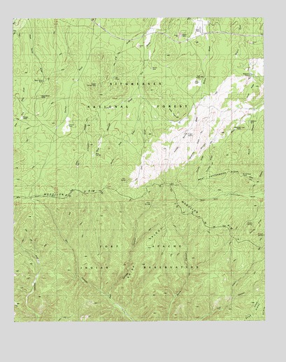
Day Spring, AZ USGS Topographic Map
Click on map above to begin viewing in our Map Viewer.

This topographic map contains these locations and features:
Feature Name Type Latitude Longitude GNIS ID View Map
Aripine Post OfficePost OfficeN34.3739°W110.4029°44810View Map
Aztec TankReservoirN34.3319°W110.4219°2745527View Map
Bailey PointSummitN34.3339°W110.4196°25892View Map
Bailey TankReservoirN34.3342°W110.4292°25348View Map
Bailey TankReservoirN34.3320°W110.4220°40147View Map
Bear SpringsSpringN34.3190°W110.4601°26118View Map
Bear Springs DrawValleyN34.3470°W110.4371°26120View Map
Bear TankReservoirN34.3187°W110.4605°40149View Map
Brinkmeyer PointSummitN34.3095°W110.3871°26743View Map
Crooked RidgeRidgeN34.3148°W110.4007°28179View Map
Day SpringSpringN34.3085°W110.4446°28307View Map
Dead Horse PointSummitN34.3431°W110.4876°28322View Map
Dead Horse TankReservoirN34.3493°W110.4853°28323View Map
Decker TankReservoirN34.3543°W110.4315°28356View Map
Deer SpringSpringN34.2986°W110.4324°23350View Map
Deer Springs Guard StationLocaleN34.2978°W110.4315°28396View Map
Deer Springs LookoutTowerN34.3062°W110.4210°1853546View Map
Dry CanyonValleyN34.2609°W110.4543°28617View Map
East Fork Hess TankReservoirN34.3411°W110.4955°2745528View Map
East Lincoln RidgeRidgeN34.3264°W110.4648°28773View Map
Hall PointSummitN34.3509°W110.4071°29695View Map
Hall TankReservoirN34.3485°W110.4080°29696View Map
Hidden SpringSpringN34.2899°W110.3845°29941View Map
Keating RidgeRidgeN34.2900°W110.3785°30713View Map
Lincoln TankReservoirN34.3310°W110.4733°31000View Map
Lower Yarrow TankReservoirN34.3489°W110.4589°2745529View Map
Moore CanyonValleyN34.3359°W110.3787°32002View Map
Newman PointSummitN34.3292°W110.3868°32314View Map
Newman TankReservoirN34.3320°W110.3828°32316View Map
Parker Number One TankReservoirN34.3675°W110.4112°40228View Map
Parker TankReservoirN34.3677°W110.4165°25347View Map
Phelps TankReservoirN34.3008°W110.3803°2745530View Map
Potato PatchAreaN34.3342°W110.4962°33137View Map
Rhine RidgeRidgeN34.2800°W110.4235°40241View Map
Shingle SpringSpringN34.2852°W110.3761°34379View Map
Smith RidgeRidgeN34.3450°W110.3818°34560View Map
Straight RidgeRidgeN34.3181°W110.4062°34883View Map
Sunny Park DrawValleyN34.3300°W110.4390°34960View Map
Telephone RidgeRidgeN34.3206°W110.4096°35184View Map
Tran TankReservoirN34.2572°W110.3753°40279View Map
Trough SpringSpringN34.3270°W110.4137°35476View Map
Trough Spring DrawValleyN34.3384°W110.4093°35477View Map
Upper Yarrow TankReservoirN34.3476°W110.4591°35734View Map
West Cottonwood RidgeRidgeN34.3078°W110.3998°35974View Map
West Lincoln TrailTrailN34.3228°W110.4946°36004View Map
Williams TanksReservoirN34.3516°W110.3819°36217View Map
Z B DrawValleyN34.3687°W110.4335°36496View Map
Z B TankReservoirN34.3505°W110.4502°36497View Map

Note: Coordinates in the location and feature list above are referenced to NAD83 datum.


Copyright (C) 2008-2024 Ryan Niemi / Sunset Dynamics ... All Rights Reserved