TopoQuest Logo
Do you find TopoQuest useful?
Help keep TopoQuest running and adding new maps/features by donating!
Bitcoin:  19c7KJd3qBynnjoSw5npx9KScwjBe4ifkT
Litecoin:  LXs6TkuXGGXo1vDsWCkWVdjQX94eUKd6ui
Home View Maps Find Maps Find Places Resources & Links


Susanville, California Topographic Map

USGS Map Title: Susanville, CA
USGS Map MRC: 40120D6
DRG (GeoTIFF) Download: o40120d6.tif


Neighboring USGS Topographic Map Quads:


  Pikes Point, CA  
40120E7
 

  Gallatin Peak, CA  
40120E6
 

  Tunnison Mountain, CA  
40120E5
 

  Roop Mountain, CA  
40120D7
 

  Susanville, CA  
40120D6
 

  Johnstonville, CA  
40120D5
 

  Fredonyer Pass, CA  
40120C7
 

  Diamond Mountain, CA  
40120C6
 

  Janesville, CA  
40120C5


Map MRC Location:

N41°
W121°
N41°
W120°
H8 H7 H6 H5 H4 H3 H2 H1
G8 G7 G6 G5 G4 G3 G2 G1
F8 F7 F6 F5 F4 F3 F2 F1
E8 E7 E6 E5 E4 E3 E2 E1
D8 D7 D6 D5 D4 D3 D2 D1
C8 C7 C6 C5 C4 C3 C2 C1
B8 B7 B6 B5 B4 B3 B2 B1
A8 A7 A6 A5 A4 A3 A2 A1
N40°
W121°
N40°
W120°

Susanville, CA USGS 1:24K Topographic Map Preview:
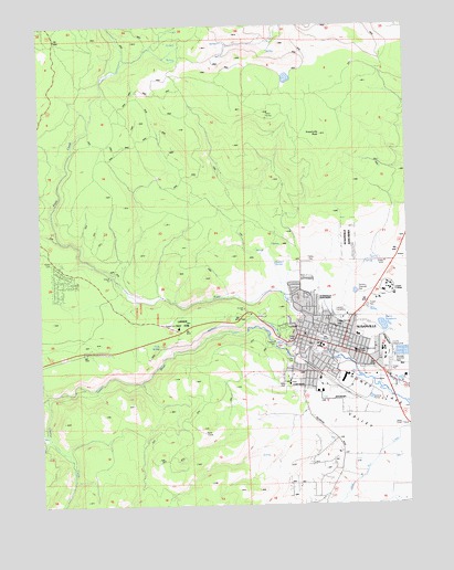
Susanville, CA USGS Topographic Map
Click on map above to begin viewing in our Map Viewer.

This topographic map contains these locations and features:
Feature Name Type Latitude Longitude GNIS ID View Map
Bagwell SpringSpringN40.4378°W120.6711°1666082View Map
Banner Lassen Medical CenterHospitalN40.4368°W120.6281°1693323View Map
Barry ReservoirReservoirN40.4212°W120.6344°1666083View Map
Brockman SloughStreamN40.4052°W120.6255°219869View Map
Bureau of Land Management Eagle Lake Field OfficeBuildingN40.4062°W120.6363°2622190View Map
Cady SpringSpringN40.4158°W120.7106°1666087View Map
California Department of Forestry and Fire Protection Lassen - Modoc Unit Fire StationBuildingN40.4239°W120.6763°2622152View Map
Calvary Baptist ChurchChurchN40.4296°W120.6583°1693299View Map
Calvary Chapel of SusanvilleChurchN40.4174°W120.6552°1693300View Map
Cheney CreekStreamN40.4032°W120.7488°220936View Map
Church of ChristChurchN40.4157°W120.6408°1693302View Map
City of SusanvilleCivilN40.4211°W120.6573°2412017View Map
Compton ParkParkN40.4243°W120.6541°1693306View Map
Credence High SchoolSchoolN40.4185°W120.6650°1693307View Map
Diamond View SchoolSchoolN40.4066°W120.6622°1693308View Map
Eagle Post OfficePost OfficeN40.4065°W120.6275°2783807View Map
First Baptist ChurchChurchN40.4196°W120.6602°1693309View Map
First Southern Baptist ChurchChurchN40.4149°W120.6513°1693311View Map
Good Shepherd Episcopal ChurchChurchN40.4193°W120.6550°1693312View Map
Gospel TabernacleChurchN40.4193°W120.6469°1693313View Map
Indian CemeteryCemeteryN40.4293°W120.6595°1693319View Map
Indian Heights Full Gospel ChurchChurchN40.4255°W120.6583°1693320View Map
Jensen SloughStreamN40.4073°W120.6380°226203View Map
KSUE-AM (Susanville)TowerN40.3952°W120.6266°1662763View Map
Lake Forest Volunteer Fire DepartmentBuildingN40.4320°W120.7424°2621885View Map
Lasen County FairgroundsParkN40.4141°W120.6338°1693326View Map
Lassen Community CollegeSchoolN40.4315°W120.6327°1666097View Map
Lassen County CemeteryCemeteryN40.4249°W120.6511°1664816View Map
Lassen County CourthouseBuildingN40.4160°W120.6633°1693325View Map
Lassen County Free LibraryBuildingN40.4166°W120.6636°1693327View Map
Lassen County Sheriff's OfficeBuildingN40.4163°W120.6634°2751084View Map
Lassen High SchoolSchoolN40.4163°W120.6561°1693328View Map
Mardis Barry 1228-002 DamDamN40.4232°W120.6361°1664264View Map
McKinley Elementary SchoolSchoolN40.4188°W120.6433°1693331View Map
Meadow View SchoolSchoolN40.4335°W120.6630°1693332View Map
Memorial ParkParkN40.4185°W120.6552°1693333View Map
Mill Pond 237-006 DamDamN40.4099°W120.6477°1663799View Map
Piute CreekStreamN40.4143°W120.6544°230784View Map
Riverside ParkParkN40.4107°W120.6513°1693337View Map
Roop Fort (historical)MilitaryN40.4186°W120.6558°1693338View Map
Roosevelt SchoolSchoolN40.4088°W120.6652°1693339View Map
Sacred Heart Catholic ChurchChurchN40.4196°W120.6591°1693340View Map
Saint Pauls Lutheran ChurchChurchN40.4166°W120.6483°1693341View Map
South Lassen AmbulanceBuildingN40.4226°W120.6464°2662234View Map
Susan River Fire Protection District Station 1BuildingN40.3802°W120.6523°2622254View Map
Susan River ParkParkN40.4143°W120.6580°1693346View Map
SusanvillePopulated PlaceN40.4163°W120.6530°277619View Map
Susanville CemeteryCemeteryN40.4157°W120.6652°1693347View Map
Susanville Church of the NazareneChurchN40.4138°W120.6558°1693348View Map
Susanville City HallBuildingN40.4196°W120.6616°1693349View Map
Susanville Fire DepartmentBuildingN40.4165°W120.6518°2621785View Map
Susanville Indian RancheriaCivilN40.4456°W120.6341°235836View Map
Susanville PeakSummitN40.4713°W120.6555°235837View Map
Susanville Police DepartmentBuildingN40.4153°W120.6471°2751049View Map
Susanville Post OfficePost OfficeN40.4193°W120.6613°1693350View Map
The Church of Jesus Christ of Latter Day SaintsChurchN40.4052°W120.6611°1693303View Map
United States Forest Service Lassen National ForestBuildingN40.4104°W120.6404°2622188View Map
Veterans Memorial HallBuildingN40.4174°W120.6552°1693352View Map
Washington SchoolSchoolN40.4166°W120.6594°1693353View Map

Note: Coordinates in the location and feature list above are referenced to NAD83 datum.


Copyright (C) 2008-2025 Ryan Niemi / Sunset Dynamics ... All Rights Reserved