TopoQuest Logo
Do you find TopoQuest useful?
Help keep TopoQuest running and adding new maps/features by donating!
Bitcoin:  19c7KJd3qBynnjoSw5npx9KScwjBe4ifkT
Litecoin:  LXs6TkuXGGXo1vDsWCkWVdjQX94eUKd6ui
Home View Maps Find Maps Find Places Resources & Links


Cold Spring Park, Colorado Topographic Map

USGS Map Title: Cold Spring Park, CO
USGS Map MRC: 38106B7
DRG (GeoTIFF) Download: o38106b7.tif


Neighboring USGS Topographic Map Quads:


  Spring Hill Creek, CO  
38106C8
 

  Sawtooth Mountain, CO  
38106C7
 

  Razor Creek Dome, CO  
38106C6
 

  Rock Creek Park, CO  
38106B8
 

  Cold Spring Park, CO  
38106B7
 

  Cochetopa Park, CO  
38106B6
 

  Stewart Peak, CO  
38106A8
 

  Elk Park, CO  
38106A7
 

  Saguache Park, CO  
38106A6


Map MRC Location:

N39°
W107°
N39°
W106°
H8 H7 H6 H5 H4 H3 H2 H1
G8 G7 G6 G5 G4 G3 G2 G1
F8 F7 F6 F5 F4 F3 F2 F1
E8 E7 E6 E5 E4 E3 E2 E1
D8 D7 D6 D5 D4 D3 D2 D1
C8 C7 C6 C5 C4 C3 C2 C1
B8 B7 B6 B5 B4 B3 B2 B1
A8 A7 A6 A5 A4 A3 A2 A1
N38°
W107°
N38°
W106°

Cold Spring Park, CO USGS 1:24K Topographic Map Preview:
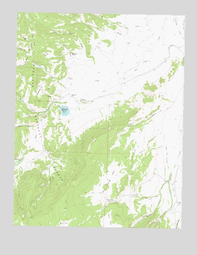
Cold Spring Park, CO USGS Topographic Map
Click on map above to begin viewing in our Map Viewer.

This topographic map contains these locations and features:
Feature Name Type Latitude Longitude GNIS ID View Map
Big BasinBasinN38.2258°W106.8667°190010View Map
Blue CreekStreamN38.1772°W106.8581°190021View Map
Cold SpringSpringN38.1411°W106.8061°190025View Map
Cold Spring ParkFlatN38.1531°W106.8037°190024View Map
Dry GulchValleyN38.2321°W106.7730°190017View Map
Fox CreekStreamN38.2208°W106.8631°189997View Map
Little BasinBasinN38.2264°W106.8534°190011View Map
Lower GulchValleyN38.2264°W106.8639°190013View Map
McDonough Number 1 DamDamN38.1633°W106.8739°199614View Map
McDonough Number 2 DamDamN38.1944°W106.8356°199616View Map
McDonough RanchLocaleN38.2011°W106.8348°190019View Map
McDonough Reservoir Number 1ReservoirN38.1633°W106.8739°199615View Map
McDonough Reservoir Number 2ReservoirN38.1929°W106.8384°190020View Map
Middle GulchValleyN38.2250°W106.8647°190012View Map
Miller CreekStreamN38.1875°W106.8562°190005View Map
Old Agency Ranger StationLocaleN38.1994°W106.8275°190027View Map
Pauline CreekStreamN38.1533°W106.7600°190022View Map
Poison GulchValleyN38.1909°W106.7510°190026View Map
Pole Road GulchValleyN38.2225°W106.8323°190014View Map
Ralston CreekStreamN38.1925°W106.8523°190006View Map
Sanderson ParkFlatN38.2056°W106.8567°190018View Map
School Section CreekStreamN38.1650°W106.8687°190000View Map
Simmons GulchValleyN38.2237°W106.8350°190015View Map
Simmons SpringSpringN38.2264°W106.8343°190016View Map
Smith Ford DitchCanalN38.2447°W106.7511°190029View Map
Tarbell and Alexander DitchCanalN38.1653°W106.7623°190028View Map
Trail CreekStreamN38.2200°W106.7845°190009View Map
Upper GulchValleyN38.2212°W106.8638°189996View Map
Willow CreekStreamN38.2483°W106.7667°189764View Map

Note: Coordinates in the location and feature list above are referenced to NAD83 datum.


Copyright (C) 2008-2024 Ryan Niemi / Sunset Dynamics ... All Rights Reserved