TopoQuest Logo
Do you find TopoQuest useful?
Help keep TopoQuest running and adding new maps/features by donating!
Bitcoin:  19c7KJd3qBynnjoSw5npx9KScwjBe4ifkT
Litecoin:  LXs6TkuXGGXo1vDsWCkWVdjQX94eUKd6ui
Home View Maps Find Maps Find Places Resources & Links


Razor Creek Dome, Colorado Topographic Map

USGS Map Title: Razor Creek Dome, CO
USGS Map MRC: 38106C6
DRG (GeoTIFF) Download: o38106c6.tif


Neighboring USGS Topographic Map Quads:


  Iris, CO  
38106D7
 

  Houston Gulch, CO  
38106D6
 

  Doyleville, CO  
38106D5
 

  Sawtooth Mountain, CO  
38106C7
 

  Razor Creek Dome, CO  
38106C6
 

  West Baldy, CO  
38106C5
 

  Cold Spring Park, CO  
38106B7
 

  Cochetopa Park, CO  
38106B6
 

  North Pass, CO  
38106B5


Map MRC Location:

N39°
W107°
N39°
W106°
H8 H7 H6 H5 H4 H3 H2 H1
G8 G7 G6 G5 G4 G3 G2 G1
F8 F7 F6 F5 F4 F3 F2 F1
E8 E7 E6 E5 E4 E3 E2 E1
D8 D7 D6 D5 D4 D3 D2 D1
C8 C7 C6 C5 C4 C3 C2 C1
B8 B7 B6 B5 B4 B3 B2 B1
A8 A7 A6 A5 A4 A3 A2 A1
N38°
W107°
N38°
W106°

Razor Creek Dome, CO USGS 1:24K Topographic Map Preview:
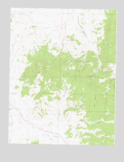
Razor Creek Dome, CO USGS Topographic Map
Click on map above to begin viewing in our Map Viewer.

This topographic map contains these locations and features:
Feature Name Type Latitude Longitude GNIS ID View Map
Dean Jones GulchValleyN38.3343°W106.6598°189779View Map
Deer HillSummitN38.2808°W106.6678°189791View Map
Flying M RanchLocaleN38.2819°W106.7498°203407View Map
Gismo CreekStreamN38.3111°W106.6264°189772View Map
Gould RanchLocaleN38.2569°W106.6936°189792View Map
Green MountainSummitN38.2903°W106.6481°189789View Map
Home GulchValleyN38.2642°W106.6865°189788View Map
Indian Creek Bog Iron MineMineN38.3258°W106.6250°1735650View Map
Irishmans Dream MineMineN38.3592°W106.7425°1745882View Map
Kathy Jo MineMineN38.3592°W106.7425°1745883View Map
Lightening GulchValleyN38.2902°W106.6844°189784View Map
Lion GulchValleyN38.3195°W106.6433°189778View Map
Lost Nueve MineMineN38.3694°W106.7367°197448View Map
Lost Ocho MineMineN38.3683°W106.7489°197445View Map
Mill CreekStreamN38.3386°W106.6548°189780View Map
Mill ParkFlatN38.3153°W106.6820°189782View Map
Moss LakeReservoirN38.2681°W106.7488°203404View Map
Myers GulchValleyN38.2515°W106.6697°189786View Map
Pole GulchValleyN38.3338°W106.6476°189771View Map
Prosser CreekStreamN38.3717°W106.6736°189777View Map
Prosser RockSummitN38.3461°W106.6784°189776View Map
Razor Creek DomeSummitN38.3161°W106.7170°189783View Map
Rocky GulchValleyN38.2849°W106.6818°189787View Map
Sage ParkFlatN38.2850°W106.6664°189790View Map
South GulchValleyN38.3181°W106.6277°189774View Map
Spruce GulchValleyN38.3616°W106.6839°189770View Map
V RockCliffN38.3244°W106.6861°189781View Map
Vouga DamDamN38.3550°W106.6639°199624View Map
Vouga ReservoirReservoirN38.3523°W106.6628°189775View Map
West Gismo CreekStreamN38.3150°W106.6273°189773View Map
West Pass CreekStreamN38.2733°W106.7498°203406View Map
Wolverine GulchValleyN38.2504°W106.6855°189785View Map

Note: Coordinates in the location and feature list above are referenced to NAD83 datum.


Copyright (C) 2008-2025 Ryan Niemi / Sunset Dynamics ... All Rights Reserved