TopoQuest Logo
Do you find TopoQuest useful?
Help keep TopoQuest running and adding new maps/features by donating!
Bitcoin:  19c7KJd3qBynnjoSw5npx9KScwjBe4ifkT
Litecoin:  LXs6TkuXGGXo1vDsWCkWVdjQX94eUKd6ui
Home View Maps Find Maps Find Places Resources & Links


Whiting, New Jersey Topographic Map

USGS Map Title: Whiting, NJ
USGS Map MRC: 39074H4
DRG (GeoTIFF) Download: o39074h4.tif


Neighboring USGS Topographic Map Quads:


  New Egypt, NJ  
40074A5
 

  Cassville, NJ  
40074A4
 

  Lakehurst, NJ  
40074A3
 

  Browns Mills, NJ  
39074H5
 

  Whiting, NJ  
39074H4
 

  Keswick Grove, NJ  
39074H3
 

  Chatsworth, NJ  
39074G5
 

  Woodmansie, NJ  
39074G4
 

  Brookville, NJ  
39074G3


Map MRC Location:

N40°
W75°
N40°
W74°
H8 H7 H6 H5 H4 H3 H2 H1
G8 G7 G6 G5 G4 G3 G2 G1
F8 F7 F6 F5 F4 F3 F2 F1
E8 E7 E6 E5 E4 E3 E2 E1
D8 D7 D6 D5 D4 D3 D2 D1
C8 C7 C6 C5 C4 C3 C2 C1
B8 B7 B6 B5 B4 B3 B2 B1
A8 A7 A6 A5 A4 A3 A2 A1
N39°
W75°
N39°
W74°

Whiting, NJ USGS 1:24K Topographic Map Preview:
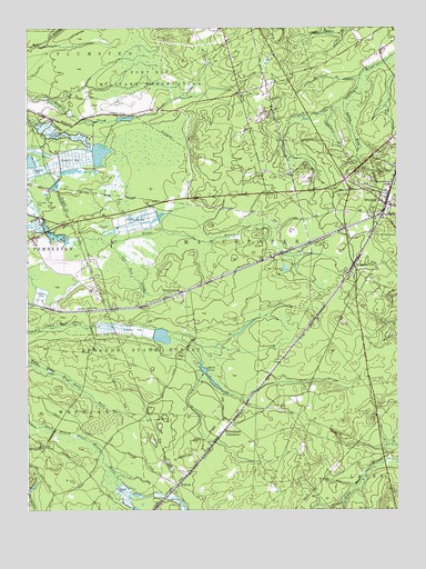
Whiting, NJ USGS Topographic Map
Click on map above to begin viewing in our Map Viewer.

This topographic map contains these locations and features:
Feature Name Type Latitude Longitude GNIS ID View Map
Bay Shore Rod and Gun ClubLocaleN39.9060°W74.4046°2047031View Map
Boyds HotelLocaleN39.9609°W74.3926°882946View Map
BuckinghamPopulated PlaceN39.9312°W74.4474°875004View Map
BullockPopulated PlaceN39.8818°W74.4496°875023View Map
Cedar Glen LakesPopulated PlaceN39.9523°W74.3999°1867356View Map
Cedar Glen Lakes Census Designated PlaceCensusN39.9527°W74.3995°2389291View Map
Deer BranchStreamN39.9440°W74.4715°875857View Map
Deer Park BranchStreamN39.9440°W74.4715°883137View Map
East Trenton Rod and Gun ClubLocaleN39.9371°W74.3829°2047032View Map
Field and Stream Gunning ClubLocaleN39.9293°W74.4479°2047033View Map
Forked BrookStreamN39.9816°W74.3924°876411View Map
Goodwater BranchStreamN39.9796°W74.3960°876671View Map
Goose PondLakeN39.9115°W74.4402°876679View Map
Hanover DamDamN39.9762°W74.4693°884354View Map
Hanover PondReservoirN39.9767°W74.4665°882422View Map
Lebanon State ForestForestN39.9076°W74.4757°877720View Map
Little Hurricane BranchStreamN39.9868°W74.3873°877842View Map
Manchester Wildlife Management AreaParkN39.9918°W74.3829°883034View Map
Pasadena Wildlife Management AreaParkN39.8918°W74.4163°883033View Map
Roosevelt CityPopulated PlaceN39.9382°W74.3890°879780View Map
Saint Johns ChurchChurchN39.9540°W74.3763°2047030View Map
Webbs Mill (historical)LocaleN39.8898°W74.3799°883175View Map
WheatlandPopulated PlaceN39.8951°W74.4338°881766View Map
WhitingPopulated PlaceN39.9546°W74.3785°881807View Map
Whiting Elementary SchoolSchoolN39.9594°W74.3774°878068View Map
Whiting Volunteer Fire Company 1BuildingN39.9547°W74.3805°2401989View Map

Note: Coordinates in the location and feature list above are referenced to NAD83 datum.


Copyright (C) 2008-2025 Ryan Niemi / Sunset Dynamics ... All Rights Reserved