TopoQuest Logo
Do you find TopoQuest useful?
Help keep TopoQuest running and adding new maps/features by donating!
Bitcoin:  19c7KJd3qBynnjoSw5npx9KScwjBe4ifkT
Litecoin:  LXs6TkuXGGXo1vDsWCkWVdjQX94eUKd6ui
Home View Maps Find Maps Find Places Resources & Links


New Egypt, New Jersey Topographic Map

USGS Map Title: New Egypt, NJ
USGS Map MRC: 40074A5
DRG (GeoTIFF) Download: o40074a5.tif


Neighboring USGS Topographic Map Quads:


  Trenton East, NJ  
40074B6
 

  Allentown, NJ  
40074B5
 

  Roosevelt, NJ  
40074B4
 

  Columbus, NJ  
40074A6
 

  New Egypt, NJ  
40074A5
 

  Cassville, NJ  
40074A4
 

  Pemberton, NJ  
39074H6
 

  Browns Mills, NJ  
39074H5
 

  Whiting, NJ  
39074H4


Map MRC Location:

N41°
W75°
N41°
W74°
H8 H7 H6 H5 H4 H3 H2 H1
G8 G7 G6 G5 G4 G3 G2 G1
F8 F7 F6 F5 F4 F3 F2 F1
E8 E7 E6 E5 E4 E3 E2 E1
D8 D7 D6 D5 D4 D3 D2 D1
C8 C7 C6 C5 C4 C3 C2 C1
B8 B7 B6 B5 B4 B3 B2 B1
A8 A7 A6 A5 A4 A3 A2 A1
N40°
W75°
N40°
W74°

New Egypt, NJ USGS 1:24K Topographic Map Preview:
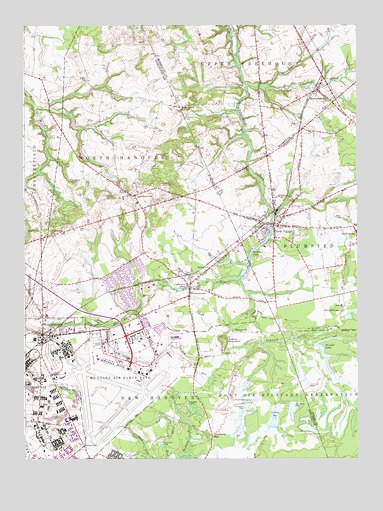
New Egypt, NJ USGS Topographic Map
Click on map above to begin viewing in our Map Viewer.

This topographic map contains these locations and features:
Feature Name Type Latitude Longitude GNIS ID View Map
ArneytownPopulated PlaceN40.1015°W74.5660°874381View Map
Arneytown Veterans Cemetery HeliportAirportN40.1007°W74.5654°884644View Map
Atlantis Elementary SchoolSchoolN40.0498°W74.5780°2373622View Map
Bethel ChurchChurchN40.0551°W74.5552°874721View Map
Brigadier General William C Doyle Veterans Memorial CemeteryCemeteryN40.0987°W74.5705°2780603View Map
Brindle LakeReservoirN40.0284°W74.5112°874946View Map
Brindle Lake DamDamN40.0326°W74.5171°884117View Map
BrindletownPopulated PlaceN40.0473°W74.5052°874947View Map
Challenger Elementary SchoolSchoolN40.0505°W74.5761°2372469View Map
Clarence B Lamb Elementary SchoolSchoolN40.0743°W74.5882°2372625View Map
Columbia Elementary SchoolSchoolN40.0462°W74.5800°2372560View Map
CookstownPopulated PlaceN40.0490°W74.5624°875620View Map
Cookstown PondReservoirN40.0496°W74.5629°875621View Map
Cookstown Volunteer Fire Company 1BuildingN40.0469°W74.5625°2401681View Map
Cranberry HallLocaleN40.0068°W74.5546°875699View Map
DavisvillePopulated PlaceN40.1098°W74.6179°883070View Map
Discovery Elementary SchoolSchoolN40.0490°W74.5808°2372194View Map
Federal Correctional Institution - Fort Dix Satellite CampBuildingN40.0002°W74.6181°2733243View Map
Fort DixPopulated PlaceN40.0298°W74.6185°876417View Map
Fort DixMilitaryN40.0129°W74.5351°2512194View Map
Fort Dix Census Designated PlaceCensusN40.0059°W74.6089°2389104View Map
Fort Dix Fire DepartmentBuildingN40.0218°W74.6185°2401965View Map
HockamikPopulated PlaceN40.0365°W74.5465°877150View Map
HornerstownPopulated PlaceN40.1062°W74.5140°877255View Map
JacobstownPopulated PlaceN40.0759°W74.5832°877402View Map
Jacobstown Volunteer Fire CompanyBuildingN40.0790°W74.5910°2401960View Map
Jumping BrookStreamN40.0516°W74.5450°877501View Map
Kings Academy SchoolSchoolN40.0369°W74.6123°2372432View Map
Lahaway CreekStreamN40.1080°W74.5408°877631View Map
Long Bog RunStreamN40.1079°W74.5325°877905View Map
Mc Guire Field (Joint Base Mc Guire Dix Lakehurst)AirportN40.0251°W74.5919°884993View Map
McGuire Air Force BaseMilitaryN40.0249°W74.5890°2512291View Map
McGuire Air Force Base Census Designated PlaceCensusN40.0285°W74.5884°2389460View Map
McGuire Air Force Base Fire DepartmentBuildingN40.0257°W74.5830°2401959View Map
McGuire Air Force Post OfficePost OfficeN40.0381°W74.5814°2781458View Map
New EgyptPopulated PlaceN40.0676°W74.5307°878733View Map
New Egypt Census Designated PlaceCensusN40.0644°W74.5284°2389541View Map
New Egypt Elementary SchoolSchoolN40.0713°W74.5268°2333278View Map
New Egypt First Aid SquadBuildingN40.0632°W74.5257°2659810View Map
New Egypt High SchoolSchoolN40.0806°W74.5306°2333265View Map
New Egypt Middle SchoolSchoolN40.0795°W74.5293°2333198View Map
New Egypt Primary SchoolSchoolN40.0825°W74.5319°2333445View Map
New Hanover Township Elementary SchoolSchoolN40.0350°W74.6188°2372564View Map
New Hanover Township Police DepartmentBuildingN40.0467°W74.5623°2730951View Map
New Jersey United Christian Academy SchoolSchoolN40.1088°W74.5344°2372948View Map
North Hanover Township Police DepartmentBuildingN40.0754°W74.5888°2730570View Map
North RunStreamN40.0517°W74.5460°878870View Map
Oakford LakeReservoirN40.0595°W74.5396°878918View Map
Oakford Lake DamDamN40.0668°W74.5318°884116View Map
Platsburg ChurchChurchN40.0648°W74.6143°879347View Map
Plumstead Township Police DepartmentBuildingN40.0666°W74.5232°2730513View Map
Plumsted Township Emergency Medical ServicesBuildingN40.0632°W74.5256°2660121View Map
Plumsted Township Fire District 1BuildingN40.0680°W74.5332°2401996View Map
PointvillePopulated PlaceN40.0037°W74.6029°882303View Map
South RunStreamN40.0343°W74.5352°880752View Map
SykesvillePopulated PlaceN40.0637°W74.6185°881067View Map
Taylors MountainSummitN40.0346°W74.5493°881107View Map
Township of New HanoverCivilN40.0159°W74.5740°882088View Map
Township of North HanoverCivilN40.0798°W74.5870°882087View Map
WrightstownPopulated PlaceN40.0362°W74.6179°881964View Map

Note: Coordinates in the location and feature list above are referenced to NAD83 datum.


Copyright (C) 2008-2024 Ryan Niemi / Sunset Dynamics ... All Rights Reserved