TopoQuest Logo
Do you find TopoQuest useful?
Help keep TopoQuest running and adding new maps/features by donating!
Bitcoin:  19c7KJd3qBynnjoSw5npx9KScwjBe4ifkT
Litecoin:  LXs6TkuXGGXo1vDsWCkWVdjQX94eUKd6ui
Home View Maps Find Maps Find Places Resources & Links


Cary, Mississippi Topographic Map

USGS Map Title: Cary, MS
USGS Map MRC: 32090G8
DRG (GeoTIFF) Download: o32090g8.tif


Neighboring USGS Topographic Map Quads:


  Mayersville, MS  
32091H1
 

  Rolling Fork West, MS  
32090H8
 

  Rolling Fork East, MS  
32090H7
 

  Whiting Bayou, MS  
32091G1
 

  Cary, MS  
32090G8
 

  Red Rock, MS  
32090G7
 

  Fitler, MS  
32091F1
 

  Onward, MS  
32090F8
 

  Valley Park, MS  
32090F7


Map MRC Location:

N33°
W91°
N33°
W90°
H8 H7 H6 H5 H4 H3 H2 H1
G8 G7 G6 G5 G4 G3 G2 G1
F8 F7 F6 F5 F4 F3 F2 F1
E8 E7 E6 E5 E4 E3 E2 E1
D8 D7 D6 D5 D4 D3 D2 D1
C8 C7 C6 C5 C4 C3 C2 C1
B8 B7 B6 B5 B4 B3 B2 B1
A8 A7 A6 A5 A4 A3 A2 A1
N32°
W91°
N32°
W90°

Cary, MS USGS 1:24K Topographic Map Preview:
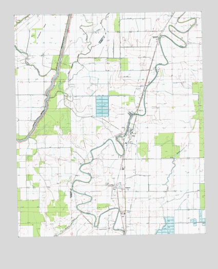
Cary, MS USGS Topographic Map
Click on map above to begin viewing in our Map Viewer.

This topographic map contains these locations and features:
Feature Name Type Latitude Longitude GNIS ID View Map
CaryPopulated PlaceN32.8060°W90.9268°668131View Map
Cary Fire DepartmentBuildingN32.8069°W90.9257°2665814View Map
Cary Post OfficePost OfficeN32.8084°W90.9243°712906View Map
Council Bend Plantation (historical)LocaleN32.8585°W90.9057°709219View Map
Danover CemeteryCemeteryN32.8476°W90.8973°669103View Map
Dry BayouStreamN32.8337°W90.9129°669389View Map
East Prong Steele BayouStreamN32.8287°W90.9784°669604View Map
EgremontPopulated PlaceN32.8607°W90.9034°669697View Map
Egremont ChapelChurchN32.8740°W90.8943°669698View Map
Guiding Star ChurchChurchN32.7932°W90.9287°670762View Map
Holly Grove ChurchChurchN32.7974°W90.9545°671319View Map
Indian BayouStreamN32.8379°W90.9645°671670View Map
IssaquenaPopulated PlaceN32.7776°W90.9340°671744View Map
Magnolia ChurchChurchN32.7607°W90.9598°673073View Map
Mount Olive ChurchChurchN32.8576°W90.9040°674141View Map
New Hope ChurchChurchN32.7537°W90.9470°674704View Map
Purddy and Sons Catfish Ponds DamDamN32.7585°W90.8834°681630View Map
Saint Michaels ChurchChurchN32.8429°W90.9048°677172View Map
Town of CaryCivilN32.8056°W90.9246°2406228View Map

Note: Coordinates in the location and feature list above are referenced to NAD83 datum.


Copyright (C) 2008-2025 Ryan Niemi / Sunset Dynamics ... All Rights Reserved