TopoQuest Logo
Do you find TopoQuest useful?
Help keep TopoQuest running and adding new maps/features by donating!
Bitcoin:  19c7KJd3qBynnjoSw5npx9KScwjBe4ifkT
Litecoin:  LXs6TkuXGGXo1vDsWCkWVdjQX94eUKd6ui
Home View Maps Find Maps Find Places Resources & Links


Caryville, Florida Topographic Map

USGS Map Title: Caryville, FL
USGS Map MRC: 30085G7
DRG (GeoTIFF) Download: o30085g7.tif


Neighboring USGS Topographic Map Quads:


  Hobbs Crossroads, FL  
30085H8
 

  Izagora, FL  
30085H7
 

  Esto, FL  
30085H6
 

  Prosperity, FL  
30085G8
 

  Caryville, FL  
30085G7
 

  Bonifay, FL  
30085G6
 

  Ponce de Leon, FL  
30085F8
 

  Hinsons Crossroads, FL  
30085F7
 

  Poplar Head, FL  
30085F6


Map MRC Location:

N31°
W86°
N31°
W85°
H8 H7 H6 H5 H4 H3 H2 H1
G8 G7 G6 G5 G4 G3 G2 G1
F8 F7 F6 F5 F4 F3 F2 F1
E8 E7 E6 E5 E4 E3 E2 E1
D8 D7 D6 D5 D4 D3 D2 D1
C8 C7 C6 C5 C4 C3 C2 C1
B8 B7 B6 B5 B4 B3 B2 B1
A8 A7 A6 A5 A4 A3 A2 A1
N30°
W86°
N30°
W85°

Caryville, FL USGS 1:24K Topographic Map Preview:
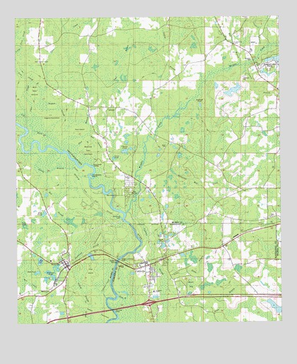
Caryville, FL USGS Topographic Map
Click on map above to begin viewing in our Map Viewer.

This topographic map contains these locations and features:
Feature Name Type Latitude Longitude GNIS ID View Map
A Bar H Ranch PondLakeN30.7710°W85.7647°298240View Map
Beaver BaySwampN30.7657°W85.7926°278361View Map
Blackman CemeteryCemeteryN30.7827°W85.8066°278955View Map
Blanchet Field HammockIslandN30.8199°W85.8408°278977View Map
Buckhead SloughGutN30.7807°W85.8416°279599View Map
Bud BranchGutN30.8238°W85.8355°279611View Map
Canebrake IslandIslandN30.8105°W85.8399°284728View Map
Caney BranchStreamN30.8555°W85.7660°279976View Map
CaryvillePopulated PlaceN30.7732°W85.8141°294706View Map
Caryville Post OfficePost OfficeN30.7717°W85.8146°2783397View Map
Caryville Volunteer Fire DepartmentBuildingN30.7720°W85.8123°2644221View Map
Catfish BranchStreamN30.8413°W85.7927°280140View Map
Cemetery PondSwampN30.7806°W85.8065°280232View Map
Cheney PondLakeN30.8207°W85.8226°280354View Map
Cooeg PondLakeN30.7757°W85.8639°280730View Map
Cooney PondLakeN30.7685°W85.8611°297632View Map
Dead RiverStreamN30.7610°W85.8272°281388View Map
Duck PondLakeN30.8004°W85.8153°281825View Map
Dyson CemeteryCemeteryN30.8213°W85.8044°281912View Map
First SloughGutN30.8510°W85.8702°282469View Map
Forehand CemeteryCemeteryN30.8496°W85.7672°282654View Map
Forehand PondLakeN30.8392°W85.7876°282655View Map
Garner FieldAirportN30.7753°W85.7681°2676701View Map
Green PondLakeN30.8175°W85.8287°2437383View Map
GritneyPopulated PlaceN30.8382°W85.8302°295324View Map
Gritney ChurchChurchN30.8221°W85.8316°300955View Map
Gritney Fire DepartmentBuildingN30.8268°W85.8355°2644026View Map
Gully BranchStreamN30.8646°W85.7719°283518View Map
Hagans HammockIslandN30.8346°W85.8585°283583View Map
Hagans SloughGutN30.8391°W85.8555°283584View Map
Hardwood LakeSwampN30.7818°W85.8462°283732View Map
Harris Chapel CemeteryCemeteryN30.8574°W85.8638°283763View Map
Hathaway MillPopulated PlaceN30.8138°W85.8013°295339View Map
Hathaway Mill CreekStreamN30.8102°W85.8166°283805View Map
Hickory Tree Flat SloughGutN30.8007°W85.8391°283970View Map
Holmes CountyCivilN30.8679°W85.8141°295735View Map
Holmes County Emergency Medical Services Station 2BuildingN30.7782°W85.8548°2661721View Map
Lawrence FieldIslandN30.7855°W85.8366°285402View Map
Limestone BranchStreamN30.8596°W85.7594°277645View Map
Little Dram BranchStreamN30.7677°W85.8030°285673View Map
Log RiverStreamN30.8210°W85.8527°285921View Map
Mac Steverson PondLakeN30.8546°W85.8605°298144View Map
Mill BranchStreamN30.8555°W85.7691°286860View Map
Mill CreekGutN30.7657°W85.8683°286866View Map
Mud PondLakeN30.7710°W85.8653°287423View Map
New Effort ChurchChurchN30.7930°W85.7549°287613View Map
New Prospect SchoolSchoolN30.7757°W85.7694°287671View Map
Paul BranchGutN30.8260°W85.8430°288583View Map
Paul BranchStreamN30.8324°W85.8408°288584View Map
Paul IslandIslandN30.8291°W85.8444°288585View Map
Pine IslandIslandN30.7716°W85.8397°288868View Map
Prosperity Elementary SchoolSchoolN30.7760°W85.8591°298499View Map
Red SloughGutN30.7994°W85.8558°289552View Map
Riverside SchoolSchoolN30.7813°W85.8499°301555View Map
Saint Marys ChurchChurchN30.7619°W85.7980°290308View Map
Saint Marys SchoolSchoolN30.7657°W85.7999°290313View Map
Shady Grove ChurchChurchN30.8557°W85.7610°290908View Map
Sikes CreekStreamN30.8341°W85.8674°291102View Map
Spring BranchGutN30.8135°W85.8566°281227View Map
Town of CaryvilleCivilN30.7753°W85.8121°2406231View Map
Town of WestvilleCivilN30.7697°W85.8465°2406872View Map
Union ChurchChurchN30.8388°W85.8297°300956View Map
Union SchoolSchoolN30.8385°W85.8285°292673View Map
WestvillePopulated PlaceN30.7746°W85.8516°293152View Map
Westville CemeteryCemeteryN30.7635°W85.8594°293153View Map
Westville Post OfficePost OfficeN30.7742°W85.8512°2783410View Map
Westville Volunteer Fire DepartmentBuildingN30.7744°W85.8513°2644158View Map
Williams PondLakeN30.7691°W85.8579°293336View Map
Wint New GroundIslandN30.8460°W85.8660°293421View Map
Winterville ChurchChurchN30.8646°W85.7708°293431View Map
WJED-FM (Dogwood Lakes Estate)TowerN30.8596°W85.7958°310179View Map
Wrights CreekStreamN30.7949°W85.8233°154040View Map
Yellow HammockIslandN30.7541°W85.8380°293582View Map
Yellow SloughGutN30.7630°W85.8438°293586View Map
Young Field SloughGutN30.8674°W85.8705°293602View Map

Note: Coordinates in the location and feature list above are referenced to NAD83 datum.


Copyright (C) 2008-2024 Ryan Niemi / Sunset Dynamics ... All Rights Reserved