TopoQuest Logo
Do you find TopoQuest useful?
Help keep TopoQuest running and adding new maps/features by donating!
Bitcoin:  19c7KJd3qBynnjoSw5npx9KScwjBe4ifkT
Litecoin:  LXs6TkuXGGXo1vDsWCkWVdjQX94eUKd6ui
Home View Maps Find Maps Find Places Resources & Links


Hobbs Crossroads, Florida Topographic Map

USGS Map Title: Hobbs Crossroads, FL
USGS Map MRC: 30085H8
DRG (GeoTIFF) Download: o30085h8.tif


Neighboring USGS Topographic Map Quads:


  Samson, AL  
31086A1
 

  Geneva West, AL  
31085A8
 

  Geneva East, AL  
31085A7
 

  Darlington, FL  
30086H1
 

  Hobbs Crossroads, FL  
30085H8
 

  Izagora, FL  
30085H7
 

  Glendale, FL  
30086G1
 

  Prosperity, FL  
30085G8
 

  Caryville, FL  
30085G7


Map MRC Location:

N31°
W86°
N31°
W85°
H8 H7 H6 H5 H4 H3 H2 H1
G8 G7 G6 G5 G4 G3 G2 G1
F8 F7 F6 F5 F4 F3 F2 F1
E8 E7 E6 E5 E4 E3 E2 E1
D8 D7 D6 D5 D4 D3 D2 D1
C8 C7 C6 C5 C4 C3 C2 C1
B8 B7 B6 B5 B4 B3 B2 B1
A8 A7 A6 A5 A4 A3 A2 A1
N30°
W86°
N30°
W85°

Hobbs Crossroads, FL USGS 1:24K Topographic Map Preview:
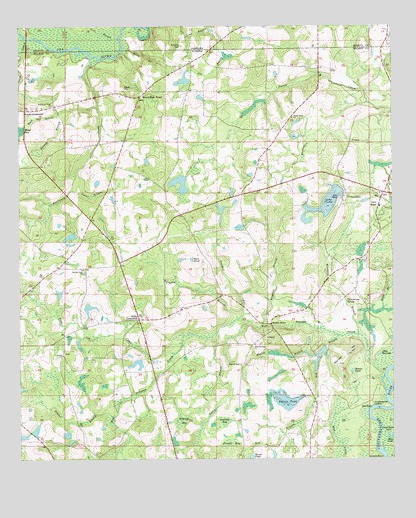
Hobbs Crossroads, FL USGS Topographic Map
Click on map above to begin viewing in our Map Viewer.

This topographic map contains these locations and features:
Feature Name Type Latitude Longitude GNIS ID View Map
Angelico BranchStreamN30.9130°W85.9194°277882View Map
Bakers PondReservoirN30.8918°W85.9117°2772077View Map
Barker StorePopulated PlaceN30.9143°W85.9160°295109View Map
Bay BranchStreamN30.9105°W85.8930°278191View Map
Beulah Anna ChurchChurchN30.9299°W85.9785°278583View Map
Blue LakeLakeN30.8814°W85.8753°279042View Map
Bonnet PondLakeN30.9004°W85.8886°279230View Map
Camp CreekStreamN30.9966°W85.9966°279891View Map
Caney BranchStreamN30.9116°W85.9338°279977View Map
Crooked RunStreamN30.9152°W85.9255°281078View Map
Dead River LakeLakeN30.8820°W85.8766°281391View Map
Dry BranchStreamN30.9985°W85.9399°293993View Map
Duck Pond BranchStreamN30.9127°W85.8991°281831View Map
Eldridge BaySwampN30.8863°W85.9456°282147View Map
Fish BranchStreamN30.9938°W85.9785°118305View Map
Fowler BranchStreamN30.9152°W85.9272°282755View Map
Grassy BranchStreamN30.9752°W85.9869°283310View Map
Gully BranchStreamN30.9946°W85.9660°119468View Map
Henry Prescott PondLakeN30.9052°W85.9630°298129View Map
Hobbs CrossroadsPopulated PlaceN30.9155°W85.9599°294808View Map
Holmes County Emergency Medical Services Station 3BuildingN30.9526°W85.8770°2661818View Map
Hurricane CreekStreamN30.9905°W85.9738°284426View Map
Hurricane Creek ChurchChurchN30.9774°W85.9885°284427View Map
Jameson BaySwampN30.8857°W85.9319°284716View Map
Lake VictorReservoirN30.9493°W85.8962°2772076View Map
Little Gar LakeLakeN30.9052°W85.8796°285687View Map
Little RiverStreamN30.9968°W85.9966°121860View Map
McDuffie CemeteryCemeteryN30.9943°W85.9472°122533View Map
Merrill BranchStreamN30.9055°W85.8999°286729View Map
Merrill CemeteryCemeteryN30.9024°W85.9260°286730View Map
Mount Olive ChurchChurchN30.9327°W85.8838°287279View Map
New HopePopulated PlaceN30.9477°W85.8794°295486View Map
New Hope Fire DepartmentBuildingN30.9526°W85.8768°2644126View Map
Old Warehouse LandingLocaleN30.8905°W85.8813°295509View Map
Open Pond ChurchChurchN30.8827°W85.9024°288177View Map
Pine Log Community Volunteer Fire and RescueBuildingN30.9007°W85.9560°2644139View Map
Pine Log CreekStreamN30.9055°W85.9483°288901View Map
Poplar BranchStreamN30.9527°W85.9819°289199View Map
Poplar Head ChurchChurchN30.9741°W85.9083°289205View Map
Powell BaySwampN30.8805°W85.9303°289275View Map
Ramer PondSwampN30.8759°W85.9226°289457View Map
Reedy ChurchChurchN30.8971°W85.9849°289603View Map
Reynold HillSummitN30.9055°W85.8902°289646View Map
Rock PondLakeN30.9329°W85.9422°289850View Map
Royals CemeteryCemeteryN30.9824°W85.9644°290044View Map
Royals CrossroadsPopulated PlaceN30.9757°W85.9977°294913View Map
Stephens Ferry BridgeBridgeN30.9971°W85.9963°127359View Map
Stevens Ferry BridgeBridgeN30.9966°W85.9972°132191View Map
Sweet Gum HeadLocaleN30.9799°W85.9594°291932View Map
Thundering SpringSpringN30.9207°W85.8908°292257View Map
Timber BranchStreamN30.8874°W85.9680°292303View Map
West Pittman ChurchChurchN30.9080°W85.9216°293111View Map
West Pittman CreekStreamN30.8949°W85.8774°277657View Map
Windmill BranchStreamN30.9107°W85.8863°293403View Map

Note: Coordinates in the location and feature list above are referenced to NAD83 datum.


Copyright (C) 2008-2025 Ryan Niemi / Sunset Dynamics ... All Rights Reserved