TopoQuest Logo
Do you find TopoQuest useful?
Help keep TopoQuest running and adding new maps/features by donating!
Bitcoin:  19c7KJd3qBynnjoSw5npx9KScwjBe4ifkT
Litecoin:  LXs6TkuXGGXo1vDsWCkWVdjQX94eUKd6ui
Home View Maps Find Maps Find Places Resources & Links


Alton, Utah Topographic Map

USGS Map Title: Alton, UT
USGS Map MRC: 37112D4
DRG (GeoTIFF) Download: o37112d4.tif


Neighboring USGS Topographic Map Quads:


  Asay Bench, UT  
37112E5
 

  George Mountain, UT  
37112E4
 

  Tropic Reservoir, UT  
37112E3
 

  Long Valley Junction, UT  
37112D5
 

  Alton, UT  
37112D4
 

  Podunk Creek, UT  
37112D3
 

  Glendale, UT  
37112C5
 

  Bald Knoll, UT  
37112C4
 

  Skutumpah Creek, UT  
37112C3


Map MRC Location:

N38°
W113°
N38°
W112°
H8 H7 H6 H5 H4 H3 H2 H1
G8 G7 G6 G5 G4 G3 G2 G1
F8 F7 F6 F5 F4 F3 F2 F1
E8 E7 E6 E5 E4 E3 E2 E1
D8 D7 D6 D5 D4 D3 D2 D1
C8 C7 C6 C5 C4 C3 C2 C1
B8 B7 B6 B5 B4 B3 B2 B1
A8 A7 A6 A5 A4 A3 A2 A1
N37°
W113°
N37°
W112°

Alton, UT USGS 1:24K Topographic Map Preview:
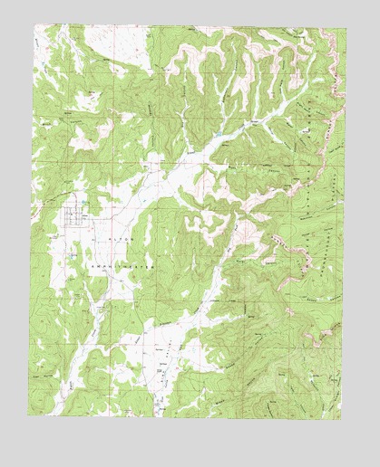
Alton, UT USGS Topographic Map
Click on map above to begin viewing in our Map Viewer.

This topographic map contains these locations and features:
Feature Name Type Latitude Longitude GNIS ID View Map
AltonPopulated PlaceN37.4378°W112.4827°1438182View Map
Alton AmphitheaterBasinN37.4333°W112.4674°1438183View Map
Alton CemeteryCemeteryN37.4319°W112.4896°1438184View Map
Alton Fire DepartmentBuildingN37.4384°W112.4830°2627339View Map
Alton Post OfficePost OfficeN37.4400°W112.4822°2769059View Map
Coal HollowValleyN37.3808°W112.4869°1439841View Map
Corral CanyonValleyN37.4691°W112.4091°1439959View Map
Don SpringSpringN37.4973°W112.3960°1440519View Map
Dry CanyonValleyN37.4644°W112.4394°1440563View Map
Dry ForkStreamN37.4200°W112.4277°1440614View Map
Kane County Ambulance - AltonBuildingN37.4386°W112.4830°2768429View Map
Left Hand CanyonValleyN37.4764°W112.4005°1442544View Map
Lower Robinson CreekStreamN37.3941°W112.4788°1443023View Map
Lower Straight CanyonValleyN37.3763°W112.3830°1443027View Map
Paunsaugunt PlateauPlainN37.5000°W112.3844°1451152View Map
Reservoir CanyonValleyN37.4680°W112.4244°1444868View Map
Right Hand CanyonValleyN37.4769°W112.3952°1444968View Map
Roundy / Johnson CemeteryCemeteryN37.4569°W112.4496°2769375View Map
Roundy CanyonValleyN37.4603°W112.4513°1445189View Map
Roundy CemeteryCemeteryN37.4551°W112.4554°2769374View Map
Rush CanyonValleyN37.4558°W112.4305°1445208View Map
Swapp HollowValleyN37.3900°W112.4383°1446278View Map
Swapp Hollow TroughValleyN37.4014°W112.4074°1451362View Map
Swapp RanchLocaleN37.3891°W112.4494°1446279View Map
The Church of Jesus Christ of Latter Day SaintsChurchN37.4394°W112.4847°1449344View Map
Water CanyonValleyN37.4233°W112.4235°1447031View Map
Water CanyonValleyN37.4716°W112.4010°1447032View Map

Note: Coordinates in the location and feature list above are referenced to NAD83 datum.


Copyright (C) 2008-2025 Ryan Niemi / Sunset Dynamics ... All Rights Reserved