TopoQuest Logo
Do you find TopoQuest useful?
Help keep TopoQuest running and adding new maps/features by donating!
Bitcoin:  19c7KJd3qBynnjoSw5npx9KScwjBe4ifkT
Litecoin:  LXs6TkuXGGXo1vDsWCkWVdjQX94eUKd6ui
Home View Maps Find Maps Find Places Resources & Links


Asay Bench, Utah Topographic Map

USGS Map Title: Asay Bench, UT
USGS Map MRC: 37112E5
DRG (GeoTIFF) Download: o37112e5.tif


Neighboring USGS Topographic Map Quads:


  Panguitch Lake, UT  
37112F6
 

  Haycock Mountain, UT  
37112F5
 

  Hatch, UT  
37112F4
 

  Henrie Knolls, UT  
37112E6
 

  Asay Bench, UT  
37112E5
 

  George Mountain, UT  
37112E4
 

  Strawberry Point, UT  
37112D6
 

  Long Valley Junction, UT  
37112D5
 

  Alton, UT  
37112D4


Map MRC Location:

N38°
W113°
N38°
W112°
H8 H7 H6 H5 H4 H3 H2 H1
G8 G7 G6 G5 G4 G3 G2 G1
F8 F7 F6 F5 F4 F3 F2 F1
E8 E7 E6 E5 E4 E3 E2 E1
D8 D7 D6 D5 D4 D3 D2 D1
C8 C7 C6 C5 C4 C3 C2 C1
B8 B7 B6 B5 B4 B3 B2 B1
A8 A7 A6 A5 A4 A3 A2 A1
N37°
W113°
N37°
W112°

Asay Bench, UT USGS 1:24K Topographic Map Preview:
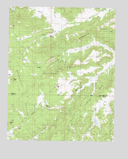
Asay Bench, UT USGS Topographic Map
Click on map above to begin viewing in our Map Viewer.

This topographic map contains these locations and features:
Feature Name Type Latitude Longitude GNIS ID View Map
Asay BenchBenchN37.5480°W112.5608°1438274View Map
Asay KnollSummitN37.5514°W112.5699°1438276View Map
Asay SpringSpringN37.5474°W112.5439°1438277View Map
Black Rock SpringSpringN37.5313°W112.5807°1438875View Map
Bowers KnollSummitN37.5561°W112.6199°1439050View Map
Buck KnollSummitN37.5691°W112.5563°1439230View Map
Burrows FlatFlatN37.5766°W112.6055°1439379View Map
Castle Creek DamDamN37.5216°W112.5241°1447628View Map
Castle Creek ReservoirReservoirN37.5216°W112.5241°1447627View Map
Castle RockPillarN37.5425°W112.5199°1439517View Map
Cold SpringSpringN37.5108°W112.6131°1439863View Map
Cub SpringSpringN37.5424°W112.5260°1440186View Map
Houston FlatFlatN37.5950°W112.6147°1441927View Map
Ikes ValleyValleyN37.5222°W112.5474°1441977View Map
Little MountainSummitN37.5772°W112.5235°1442744View Map
Mammoth RidgeRidgeN37.6066°W112.5274°1443117View Map
McDonald LakeReservoirN37.5100°W112.5294°1447625View Map
McDonald Lake DamDamN37.5100°W112.5294°1447626View Map
Sawyer PointCapeN37.5530°W112.5085°1445361View Map
Spring HollowValleyN37.6211°W112.6224°1446046View Map
Strawberry CreekStreamN37.5303°W112.5530°1446180View Map
Swains CreekStreamN37.5303°W112.5530°1446268View Map
Uinta FlatFlatN37.5378°W112.5883°1446828View Map
White FacePillarN37.6069°W112.6235°1447246View Map
Wilson CreekStreamN37.6122°W112.5641°1447453View Map
Wilson SpringSpringN37.5984°W112.5761°1447461View Map

Note: Coordinates in the location and feature list above are referenced to NAD83 datum.


Copyright (C) 2008-2025 Ryan Niemi / Sunset Dynamics ... All Rights Reserved