TopoQuest Logo
Do you find TopoQuest useful?
Help keep TopoQuest running and adding new maps/features by donating!
Bitcoin:  19c7KJd3qBynnjoSw5npx9KScwjBe4ifkT
Litecoin:  LXs6TkuXGGXo1vDsWCkWVdjQX94eUKd6ui
Home View Maps Find Maps Find Places Resources & Links


Catfish Point, Mississippi Topographic Map

USGS Map Title: Catfish Point, MS
USGS Map MRC: 33091F2
DRG (GeoTIFF) Download: o33091f2.tif


Neighboring USGS Topographic Map Quads:


  Kelso, AR  
33091G3
 

  Lake Cheatham, AR  
33091G2
 

  Rosedale, MS  
33091G1
 

  McArthur, AR  
33091F3
 

  Catfish Point, MS  
33091F2
 

  Benoit, MS  
33091F1
 

  Halley, AR  
33091E3
 

  Arkansas City, AR  
33091E2
 

  Scott, MS  
33091E1


Map MRC Location:

N34°
W92°
N34°
W91°
H8 H7 H6 H5 H4 H3 H2 H1
G8 G7 G6 G5 G4 G3 G2 G1
F8 F7 F6 F5 F4 F3 F2 F1
E8 E7 E6 E5 E4 E3 E2 E1
D8 D7 D6 D5 D4 D3 D2 D1
C8 C7 C6 C5 C4 C3 C2 C1
B8 B7 B6 B5 B4 B3 B2 B1
A8 A7 A6 A5 A4 A3 A2 A1
N33°
W92°
N33°
W91°

Catfish Point, MS USGS 1:24K Topographic Map Preview:
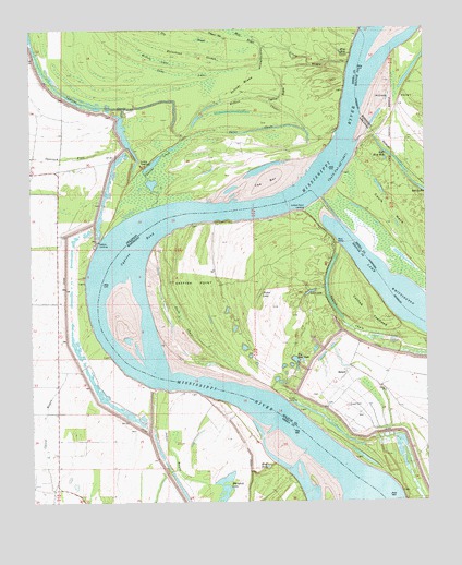
Catfish Point, MS USGS Topographic Map
Click on map above to begin viewing in our Map Viewer.

This topographic map contains these locations and features:
Feature Name Type Latitude Longitude GNIS ID View Map
Big Blue HoleLakeN33.6621°W91.1665°667079View Map
Blue HoleLakeN33.6343°W91.1759°74680View Map
Blue HoleLakeN33.7437°W91.1512°74681View Map
Bobs Blue HoleLakeN33.7163°W91.1358°74692View Map
Catfish ChuteGutN33.6743°W91.1526°668160View Map
Catfish PointCapeN33.6809°W91.1987°668162View Map
Catfish Point AirportAirportN33.7008°W91.1642°2676427View Map
Catfish Point LandingPopulated PlaceN33.7023°W91.1634°691757View Map
Catfish TowheadAreaN33.6751°W91.1437°668163View Map
Caulk Cut-offBendN33.7168°W91.1543°76549View Map
Caulk Landing (historical)LocaleN33.7250°W91.1500°2548767View Map
Caulk NeckAreaN33.6965°W91.1296°47535View Map
Chicot Landing (historical)LocaleN33.6365°W91.1626°63847View Map
Crazy BayouGutN33.7423°W91.1618°48151View Map
Cypress BayouGutN33.7323°W91.1704°48290View Map
Cypress BendBendN33.6898°W91.2082°669042View Map
Cypress Bend RevetmentLeveeN33.6629°W91.2248°70285View Map
Cypress CreekStreamN33.7029°W91.2112°76737View Map
DeSoto LandingLocaleN33.6929°W91.2293°76761View Map
Dry SloughGutN33.7484°W91.2034°48672View Map
Duck ChuteSwampN33.6737°W91.2029°669469View Map
EutawPopulated PlaceN33.6587°W91.1507°669829View Map
Eutaw CemeteryCemeteryN33.6501°W91.1501°669830View Map
Eutaw ChurchChurchN33.6540°W91.1384°669831View Map
Eutaw LandingPopulated PlaceN33.6518°W91.1701°691849View Map
Eutaw Store (historical)LocaleN33.6554°W91.1396°687980View Map
Hobson ChuteGutN33.7318°W91.1790°50159View Map
Horsehead SloughGutN33.7446°W91.2065°50334View Map
Island Number SeventysevenIslandN33.6979°W91.1798°688059View Map
Johns BayouGutN33.6379°W91.2057°50666View Map
Lake WhittingtonLakeN33.6746°W91.1261°75221View Map
Long LakeSwampN33.7382°W91.2018°51433View Map
Lost LakeLakeN33.6803°W91.1617°672875View Map
Lucca BarBarN33.6734°W91.2215°687994View Map
Lucca LandingPopulated PlaceN33.7154°W91.2151°58098View Map
Mills Bayou DitchCanalN33.7423°W91.1762°52077View Map
Nebletts Landing (historical)LocaleN33.6454°W91.1584°688007View Map
Outer ChuteGutN33.7232°W91.1787°53093View Map
Ozark ChuteStreamN33.7496°W91.1446°53124View Map
Picket LakeSwampN33.6798°W91.1779°675705View Map
Potlatch Corporation AmbulanceBuildingN33.7088°W91.2409°2119048View Map
Prentiss (historical)Populated PlaceN33.7334°W91.1390°710138View Map
The BarBarN33.7093°W91.1754°55505View Map
Township of FranklinCivilN33.7375°W91.1563°66499View Map
Whitehill LakeLakeN33.6284°W91.1894°75219View Map
Willow LakeSwampN33.7421°W91.2096°56416View Map
Zellner BrakeGutN33.7354°W91.1821°56623View Map

Note: Coordinates in the location and feature list above are referenced to NAD83 datum.


Copyright (C) 2008-2025 Ryan Niemi / Sunset Dynamics ... All Rights Reserved