TopoQuest Logo
Do you find TopoQuest useful?
Help keep TopoQuest running and adding new maps/features by donating!
Bitcoin:  19c7KJd3qBynnjoSw5npx9KScwjBe4ifkT
Litecoin:  LXs6TkuXGGXo1vDsWCkWVdjQX94eUKd6ui
Home View Maps Find Maps Find Places Resources & Links


Mount Powell, Colorado Topographic Map

USGS Map Title: Mount Powell, CO
USGS Map MRC: 39106G3
DRG (GeoTIFF) Download: o39106g3.tif


Neighboring USGS Topographic Map Quads:


  Sheephorn Mountain, CO  
39106H4
 

  King Creek, CO  
39106H3
 

  Battle Mountain, CO  
39106H2
 

  Piney Peak, CO  
39106G4
 

  Mount Powell, CO  
39106G3
 

  Squaw Creek, CO  
39106G2
 

  Vail West, CO  
39106F4
 

  Vail East, CO  
39106F3
 

  Willow Lakes, CO  
39106F2


Map MRC Location:

N40°
W107°
N40°
W106°
H8 H7 H6 H5 H4 H3 H2 H1
G8 G7 G6 G5 G4 G3 G2 G1
F8 F7 F6 F5 F4 F3 F2 F1
E8 E7 E6 E5 E4 E3 E2 E1
D8 D7 D6 D5 D4 D3 D2 D1
C8 C7 C6 C5 C4 C3 C2 C1
B8 B7 B6 B5 B4 B3 B2 B1
A8 A7 A6 A5 A4 A3 A2 A1
N39°
W107°
N39°
W106°

Mount Powell, CO USGS 1:24K Topographic Map Preview:
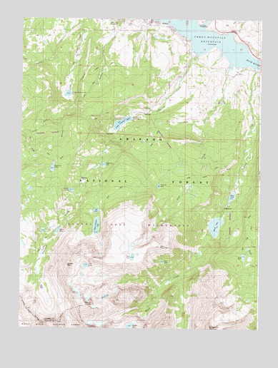
Mount Powell, CO USGS Topographic Map
Click on map above to begin viewing in our Map Viewer.

This topographic map contains these locations and features:
Feature Name Type Latitude Longitude GNIS ID View Map
Black CreekStreamN39.8555°W106.2517°175665View Map
Black Creek DamDamN39.8067°W106.2639°199774View Map
Black Creek ReservoirReservoirN39.8034°W106.2646°199775View Map
Black LakeLakeN39.7916°W106.2729°175653View Map
Bubble LakeLakeN39.7500°W106.3177°202341View Map
Cat LakeLakeN39.7975°W106.3355°2712371View Map
Cataract CreekStreamN39.8711°W106.2822°175614View Map
Cliff LakeLakeN39.7755°W106.3406°175643View Map
Cottonwood GulchValleyN39.8590°W106.2513°196491View Map
Cox GulchValleyN39.8691°W106.2645°196489View Map
Doig LakeLakeN39.7771°W106.3007°2712496View Map
Dora LakeLakeN39.7788°W106.3164°2712497View Map
Dora MountainSummitN39.7850°W106.2970°175609View Map
Duck LakeLakeN39.7629°W106.3302°2712477View Map
Eagles NestSummitN39.7744°W106.3506°175644View Map
Eaglesmere LakesLakeN39.8149°W106.3586°175647View Map
Eaglesmere TrailTrailN39.8358°W106.3359°197207View Map
Green Mountain ReservoirReservoirN39.8714°W106.2852°196488View Map
Griffith LakeLakeN39.8058°W106.3487°196551View Map
Guthrie Thomas DitchCanalN39.8546°W106.3361°2712498View Map
HeeneyPopulated PlaceN39.8725°W106.3011°169363View Map
Heeney Census Designated PlaceCensusN39.8740°W106.3078°2583244View Map
Hoagland Number 1 DamDamN39.8483°W106.3489°199770View Map
Hoagland Reservoir Number 1ReservoirN39.8447°W106.3508°199771View Map
Lakeside HallLocaleN39.8711°W106.2864°175613View Map
Lost LakeLakeN39.7795°W106.2581°175652View Map
Lost Lake DamDamN39.7800°W106.2572°199772View Map
Lost Lake TrailTrailN39.7808°W106.2520°202311View Map
Lower Blue Fire Protection DistrictBuildingN39.8720°W106.3074°2667354View Map
Lower Cataract LakeLakeN39.8330°W106.3230°175608View Map
Martin CreekStreamN39.8747°W106.3436°175616View Map
Mirror LakeLakeN39.7894°W106.3556°175645View Map
Mount PowellSummitN39.7600°W106.3407°175642View Map
North Fork Elliott CreekStreamN39.8364°W106.3559°175622View Map
Otter CreekStreamN39.8667°W106.2661°175615View Map
Surprise LakeLakeN39.8077°W106.3029°175654View Map
Surprise TrailTrailN39.8217°W106.3073°197208View Map
Tipperary LakeLakeN39.8162°W106.3319°175655View Map
Upper Cataract LakeLakeN39.7912°W106.3352°175646View Map

Note: Coordinates in the location and feature list above are referenced to NAD83 datum.


Copyright (C) 2008-2025 Ryan Niemi / Sunset Dynamics ... All Rights Reserved