TopoQuest Logo
Do you find TopoQuest useful?
Help keep TopoQuest running and adding new maps/features by donating!
Bitcoin:  19c7KJd3qBynnjoSw5npx9KScwjBe4ifkT
Litecoin:  LXs6TkuXGGXo1vDsWCkWVdjQX94eUKd6ui
Home View Maps Find Maps Find Places Resources & Links


Vail West, Colorado Topographic Map

USGS Map Title: Vail West, CO
USGS Map MRC: 39106F4
DRG (GeoTIFF) Download: o39106f4.tif


Neighboring USGS Topographic Map Quads:


  Lava Creek, CO  
39106G5
 

  Piney Peak, CO  
39106G4
 

  Mount Powell, CO  
39106G3
 

  Edwards, CO  
39106F5
 

  Vail West, CO  
39106F4
 

  Vail East, CO  
39106F3
 

  Grouse Mountain, CO  
39106E5
 

  Minturn, CO  
39106E4
 

  Red Cliff, CO  
39106E3


Map MRC Location:

N40°
W107°
N40°
W106°
H8 H7 H6 H5 H4 H3 H2 H1
G8 G7 G6 G5 G4 G3 G2 G1
F8 F7 F6 F5 F4 F3 F2 F1
E8 E7 E6 E5 E4 E3 E2 E1
D8 D7 D6 D5 D4 D3 D2 D1
C8 C7 C6 C5 C4 C3 C2 C1
B8 B7 B6 B5 B4 B3 B2 B1
A8 A7 A6 A5 A4 A3 A2 A1
N39°
W107°
N39°
W106°

Vail West, CO USGS 1:24K Topographic Map Preview:
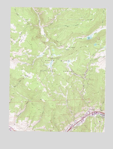
Vail West, CO USGS Topographic Map
Click on map above to begin viewing in our Map Viewer.

This topographic map contains these locations and features:
Feature Name Type Latitude Longitude GNIS ID View Map
Buffehr CreekStreamN39.6328°W106.4123°175911View Map
Coyote ClaimsMineN39.7244°W106.4825°1735856View Map
Coyote Claims MineMineN39.7244°W106.4825°1684182View Map
Dickson CreekStreamN39.7144°W106.4481°175917View Map
Eagle County Ambulance District Avon StationBuildingN39.6294°W106.4944°2735541View Map
Eagle County Ambulance District Vail StationBuildingN39.6434°W106.3824°2735588View Map
East Meadow CreekStreamN39.7305°W106.4511°175924View Map
Flagstone ParkFlatN39.7364°W106.4795°175914View Map
Freeman CreekStreamN39.7086°W106.4492°175918View Map
Indian CreekStreamN39.6786°W106.4025°175910View Map
KSKE-FM (Vail)TowerN39.6355°W106.4467°204201View Map
KZYR-FM (Avon)TowerN39.6355°W106.4467°204087View Map
Lost LakeLakeN39.7133°W106.3893°175920View Map
Lost Lake TrailTrailN39.7080°W106.4106°175909View Map
Marugg CreekStreamN39.7294°W106.3806°175922View Map
Meadow CreekStreamN39.7294°W106.4603°175664View Map
Middle CreekStreamN39.6433°W106.3845°175925View Map
Moniger CreekStreamN39.7308°W106.4620°175915View Map
Moniger ParkFlatN39.7189°W106.4836°175916View Map
Nottingham DamDamN39.6350°W106.4923°201540View Map
Nottingham GulchValleyN39.6310°W106.4926°203931View Map
Nottingham ReservoirReservoirN39.6351°W106.4906°201541View Map
Nottingham Ridge TrailTrailN39.6547°W106.4714°202338View Map
Piney Crossing CampgroundLocaleN39.7103°W106.4206°175919View Map
Piney LakeLakeN39.7201°W106.3974°175921View Map
Red Sandstone CreekStreamN39.6408°W106.3959°175926View Map
Red SpringSpringN39.6808°W106.4805°175913View Map
South Fork Dickson CreekStreamN39.7003°W106.4634°175912View Map
South Fork Red Sandstone CreekStreamN39.6978°W106.3939°175927View Map
Spraddle CreekStreamN39.6422°W106.3800°175928View Map
Vail Fire Department Station 2BuildingN39.6421°W106.3789°2666855View Map
Vail Fire Department West Vail StationBuildingN39.6279°W106.4223°2667212View Map
Vail Police DepartmentBuildingN39.6440°W106.3802°2735525View Map
Vail Post OfficePost OfficeN39.6381°W106.4069°2734629View Map
Vail Valley Medical CenterHospitalN39.6432°W106.3824°2695623View Map
West VailPopulated PlaceN39.6303°W106.4148°202340View Map

Note: Coordinates in the location and feature list above are referenced to NAD83 datum.


Copyright (C) 2008-2025 Ryan Niemi / Sunset Dynamics ... All Rights Reserved