TopoQuest Logo
Do you find TopoQuest useful?
Help keep TopoQuest running and adding new maps/features by donating!
Bitcoin:  19c7KJd3qBynnjoSw5npx9KScwjBe4ifkT
Litecoin:  LXs6TkuXGGXo1vDsWCkWVdjQX94eUKd6ui
Home View Maps Find Maps Find Places Resources & Links


West Lake, Maine Topographic Map

USGS Map Title: West Lake, ME
USGS Map MRC: 45068A2
DRG (GeoTIFF) Download: o45068a2.tif


Neighboring USGS Topographic Map Quads:


  Saponac, ME  
45068B3
 

  Spring Lake, ME  
45068B2
 

  Duck Lake, ME  
45068B1
 

  Brandy Pond, ME  
45068A3
 

  West Lake, ME  
45068A2
 

  Gassabias Lake, ME  
45068A1
 

  Great Pond, ME  
44068H3
 

  Alligator Lake, ME  
44068H2
 

  Quillpig Mountain, ME  
44068H1


Map MRC Location:

N46°
W69°
N46°
W68°
H8 H7 H6 H5 H4 H3 H2 H1
G8 G7 G6 G5 G4 G3 G2 G1
F8 F7 F6 F5 F4 F3 F2 F1
E8 E7 E6 E5 E4 E3 E2 E1
D8 D7 D6 D5 D4 D3 D2 D1
C8 C7 C6 C5 C4 C3 C2 C1
B8 B7 B6 B5 B4 B3 B2 B1
A8 A7 A6 A5 A4 A3 A2 A1
N45°
W69°
N45°
W68°

West Lake, ME USGS 1:24K Topographic Map Preview:
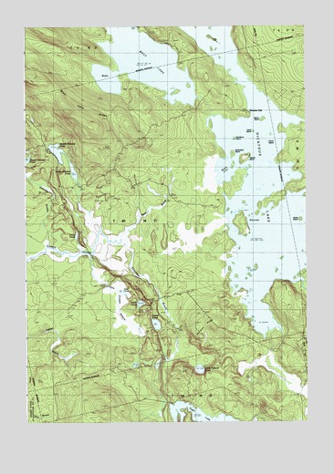
West Lake, ME USGS Topographic Map
Click on map above to begin viewing in our Map Viewer.

This topographic map contains these locations and features:
Feature Name Type Latitude Longitude GNIS ID View Map
Abamgamook LakeLakeN45.1159°W68.1981°578166View Map
Bacon IslandIslandN45.0956°W68.1456°561423View Map
Butterfield IslandIslandN45.0851°W68.1592°563309View Map
Coombs BrookStreamN45.0448°W68.1286°564326View Map
Cranberry IslandIslandN45.0898°W68.1578°564463View Map
Crystal PondLakeN45.0310°W68.1919°564638View Map
Dayton IslandIslandN45.0840°W68.1525°564846View Map
Dollar IslandIslandN45.0634°W68.1286°565186View Map
Eagle BrookStreamN45.0017°W68.1839°565484View Map
Eagle LakeLakeN45.0018°W68.1716°565496View Map
Eagle Lake TrailTrailN45.0131°W68.1914°565500View Map
Little Guagus StreamStreamN45.0528°W68.2225°569810View Map
Little Pickerel PondLakeN45.0169°W68.1726°569957View Map
Loon PondLakeN45.0376°W68.1989°570373View Map
Lower Oxhead PondLakeN45.0793°W68.2283°570526View Map
Mace BrookStreamN45.0573°W68.2081°570611View Map
Middle Oxhead PondLakeN45.0856°W68.2356°571258View Map
Moose CoveBayN45.0798°W68.1611°571588View Map
Morrison RidgeRidgeN45.0298°W68.1686°571689View Map
Nicatous ClubLocaleN45.0976°W68.1517°572156View Map
Nicatous LakeReservoirN45.0816°W68.1505°572157View Map
Otter PondLakeN45.0409°W68.2063°572835View Map
Oxhead StreamStreamN45.0592°W68.2431°572902View Map
Partridge BrookStreamN45.0576°W68.2083°573025View Map
Perch IslandIslandN45.0887°W68.1428°573190View Map
Sand IslandIslandN45.0920°W68.1492°574844View Map
T40 MD BPPCivilN45.0713°W68.1983°2748808View Map
Trout PondLakeN45.0592°W68.2271°577350View Map
West LakeLakeN45.1133°W68.1971°578847View Map
West Lake RidgeRidgeN45.0981°W68.2317°578167View Map

Note: Coordinates in the location and feature list above are referenced to NAD83 datum.


Copyright (C) 2008-2025 Ryan Niemi / Sunset Dynamics ... All Rights Reserved