TopoQuest Logo
Do you find TopoQuest useful?
Help keep TopoQuest running and adding new maps/features by donating!
Bitcoin:  19c7KJd3qBynnjoSw5npx9KScwjBe4ifkT
Litecoin:  LXs6TkuXGGXo1vDsWCkWVdjQX94eUKd6ui
Home View Maps Find Maps Find Places Resources & Links


Great Pond, Maine Topographic Map

USGS Map Title: Great Pond, ME
USGS Map MRC: 44068H3
DRG (GeoTIFF) Download: o44068h3.tif


Neighboring USGS Topographic Map Quads:


  Greenfield, ME  
45068A4
 

  Brandy Pond, ME  
45068A3
 

  West Lake, ME  
45068A2
 

  The Horseback, ME  
44068H4
 

  Great Pond, ME  
44068H3
 

  Alligator Lake, ME  
44068H2
 

  Hopkins Pond, ME  
44068G4
 

  Amherst, ME  
44068G3
 

  Rocky Pond, ME  
44068G2


Map MRC Location:

N45°
W69°
N45°
W68°
H8 H7 H6 H5 H4 H3 H2 H1
G8 G7 G6 G5 G4 G3 G2 G1
F8 F7 F6 F5 F4 F3 F2 F1
E8 E7 E6 E5 E4 E3 E2 E1
D8 D7 D6 D5 D4 D3 D2 D1
C8 C7 C6 C5 C4 C3 C2 C1
B8 B7 B6 B5 B4 B3 B2 B1
A8 A7 A6 A5 A4 A3 A2 A1
N44°
W69°
N44°
W68°

Great Pond, ME USGS 1:24K Topographic Map Preview:
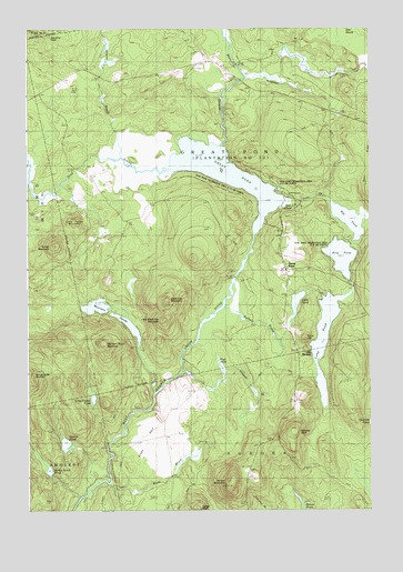
Great Pond, ME USGS Topographic Map
Click on map above to begin viewing in our Map Viewer.

This topographic map contains these locations and features:
Feature Name Type Latitude Longitude GNIS ID View Map
Allagash BrookStreamN44.9092°W68.3206°561168View Map
Alligator StreamStreamN44.9876°W68.2945°561210View Map
Black Cap MountainSummitN44.9297°W68.3241°562421View Map
Carter BluffCliffN44.8759°W68.3131°563633View Map
Collar BrookStreamN44.9556°W68.2831°564224View Map
Cone HillSummitN44.9189°W68.2737°564287View Map
Dead StreamStreamN44.9637°W68.3261°564890View Map
Dow PinesPopulated PlaceN44.9531°W68.2834°579255View Map
Dow Pines Recreation AreaParkN44.9626°W68.2786°1911540View Map
Dutton PondLakeN44.8922°W68.3612°565446View Map
Great PondPopulated PlaceN44.9403°W68.2820°567172View Map
Great PondReservoirN44.9622°W68.3023°567173View Map
Great Pond CemeteryCemeteryN44.9459°W68.2820°567174View Map
Hinkley BrookStreamN44.9667°W68.3392°568104View Map
King PondLakeN44.9408°W68.2603°569203View Map
Little Black Cap MountainSummitN44.9245°W68.3248°569690View Map
Little Dutton PondLakeN44.9040°W68.3510°569759View Map
Little PondLakeN44.9291°W68.2766°569979View Map
Little Turner MountainSummitN44.9500°W68.3571°570089View Map
Long PondLakeN44.9197°W68.2663°570284View Map
Main StreamStreamN44.9695°W68.3036°570670View Map
Morrison Pond MountainSummitN44.9183°W68.3470°571687View Map
Morrison PondsLakeN44.9280°W68.3499°571688View Map
Pug HoleLakeN44.9122°W68.3042°573864View Map
Rift PondLakeN44.9503°W68.2573°574211View Map
Roberts BluffCliffN44.8953°W68.2795°574296View Map
Silsby PlainFlatN44.8906°W68.3336°575458View Map
Spring Brook PondLakeN44.8855°W68.3670°576096View Map
Springy Brook MountainSummitN44.9109°W68.3747°576125View Map
Spruce MountainSummitN44.8815°W68.3012°576145View Map
Sucker BrookStreamN44.9278°W68.3028°576480View Map
The BirchesLocaleN44.9165°W68.2717°576755View Map
Town of Great PondCivilN44.9588°W68.2991°582498View Map
Turner MountainSummitN44.9437°W68.3652°577432View Map
Warm BrookStreamN44.8815°W68.3436°577840View Map
Washington SchoolSchoolN44.9381°W68.2806°577865View Map

Note: Coordinates in the location and feature list above are referenced to NAD83 datum.


Copyright (C) 2008-2024 Ryan Niemi / Sunset Dynamics ... All Rights Reserved