TopoQuest Logo
Do you find TopoQuest useful?
Help keep TopoQuest running and adding new maps/features by donating!
Bitcoin:  19c7KJd3qBynnjoSw5npx9KScwjBe4ifkT
Litecoin:  LXs6TkuXGGXo1vDsWCkWVdjQX94eUKd6ui
Home View Maps Find Maps Find Places Resources & Links


Cathlamet Bay, Oregon Topographic Map

USGS Map Title: Cathlamet Bay, OR
USGS Map MRC: 46123B6
DRG (GeoTIFF) Download: o46123b6.tif


Neighboring USGS Topographic Map Quads:


  Knappton, WA  
46123C7
 

  Rosburg, WA  
46123C6
 

  Grays River, WA  
46123C5
 

  Astoria, OR  
46123B7
 

  Cathlamet Bay, OR  
46123B6
 

  Knappa, OR  
46123B5
 

  Olney, OR  
46123A7
 

  Green Mountain, OR  
46123A6
 

  Wickiup Mountain, OR  
46123A5


Map MRC Location:

N47°
W124°
N47°
W123°
H8 H7 H6 H5 H4 H3 H2 H1
G8 G7 G6 G5 G4 G3 G2 G1
F8 F7 F6 F5 F4 F3 F2 F1
E8 E7 E6 E5 E4 E3 E2 E1
D8 D7 D6 D5 D4 D3 D2 D1
C8 C7 C6 C5 C4 C3 C2 C1
B8 B7 B6 B5 B4 B3 B2 B1
A8 A7 A6 A5 A4 A3 A2 A1
N46°
W124°
N46°
W123°

Cathlamet Bay, OR USGS 1:24K Topographic Map Preview:
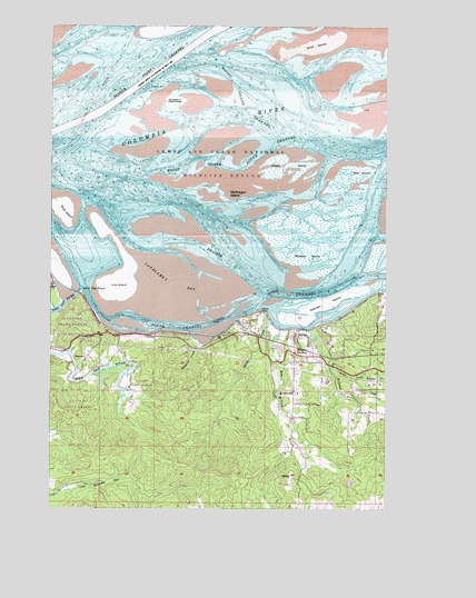
Cathlamet Bay, OR USGS Topographic Map
Click on map above to begin viewing in our Map Viewer.

This topographic map contains these locations and features:
Feature Name Type Latitude Longitude GNIS ID View Map
Beacon Number FourBuildingN46.2441°W123.6984°1117335View Map
Beacon Number TwoBuildingN46.2342°W123.7142°1117334View Map
Bear CreekStreamN46.1715°W123.6654°1117365View Map
Biddle (historical)Populated PlaceN46.1329°W123.6607°1158123View Map
Big Creek SloughStreamN46.1962°W123.6301°1138013View Map
Burnside (historical)Populated PlaceN46.1751°W123.6782°1167944View Map
Calendar SloughStreamN46.1851°W123.6368°1118460View Map
Cathlamet BayBayN46.1896°W123.7174°1118693View Map
Clatsop County Sheriff's Office Columbia River Valley SubstationBuildingN46.1593°W123.6600°2737879View Map
Davis CreekStreamN46.1943°W123.6957°1132294View Map
East LightBuildingN46.1926°W123.6922°1120341View Map
Eskeline CreekStreamN46.1682°W123.6951°1120519View Map
Fern HillPopulated PlaceN46.1646°W123.7371°1136282View Map
Fern Hill Post Office (historical)Post OfficeN46.1646°W123.7371°1165246View Map
Fernhill (historical)LocaleN46.1721°W123.7304°1167945View Map
Fernhill Holly FarmsLocaleN46.1647°W123.7378°2664419View Map
Ferris CreekStreamN46.1618°W123.6460°1120685View Map
Front Range LightBuildingN46.2274°W123.7375°1121010View Map
Grassy IslandIslandN46.1965°W123.7021°1158267View Map
Green IslandIslandN46.2140°W123.6626°1121380View Map
Harrington Point RangeChannelN46.2379°W123.7126°1121616View Map
Hilda Lahti Elementary SchoolSchoolN46.1632°W123.6253°2392949View Map
Hillcrest CreekStreamN46.1715°W123.6549°1158289View Map
Ivy StationLocaleN46.1812°W123.6271°1156647View Map
John Day ChannelChannelN46.1915°W123.7429°1158969View Map
John Day County ParkParkN46.1751°W123.7415°2058190View Map
John Day PointCapeN46.1812°W123.7396°1122448View Map
John Day RiverStreamN46.1814°W123.7406°1122449View Map
John Day Rural Fire Protection DepartmentBuildingN46.1661°W123.7487°2577029View Map
Karpens AirportAirportN46.1626°W123.6404°1131666View Map
Knappa Svensen Rural Fire Protection Department Station 2BuildingN46.1669°W123.6572°2577023View Map
Little Bear CreekStreamN46.1540°W123.6665°1132297View Map
Little Ferris CreekStreamN46.1584°W123.6376°1123191View Map
Lois IslandIslandN46.1873°W123.7218°1123360View Map
Marys CreekStreamN46.1729°W123.6679°1123822View Map
McGregor IslandIslandN46.2059°W123.6865°1123967View Map
Miller SandsIslandN46.2443°W123.6532°1124205View Map
Mott IslandIslandN46.2023°W123.7451°1124401View Map
North ChannelChannelN46.2040°W123.7021°1135916View Map
North IslandIslandN46.2165°W123.6318°1158624View Map
Prairie ChannelChannelN46.2004°W123.6329°1125646View Map
Rear Range LightBuildingN46.2339°W123.7266°1125861View Map
Rock CreekStreamN46.1554°W123.6679°1129859View Map
Russian IslandIslandN46.1907°W123.6549°1126377View Map
Seal IslandIslandN46.2115°W123.6393°1126710View Map
Settler PointCapeN46.1757°W123.6718°1126755View Map
South ChannelChannelN46.1718°W123.7046°1127240View Map
Spear CreekStreamN46.2137°W123.6346°1132313View Map
SvensenPopulated PlaceN46.1707°W123.6593°1127780View Map
Svensen IslandIslandN46.1784°W123.6482°1127781View Map
Svensen JunctionPopulated PlaceN46.1654°W123.6599°1127782View Map
Svensen Pioneer CemeteryCemeteryN46.1592°W123.6488°1158241View Map
Svensen Post Office (historical)Post OfficeN46.1707°W123.6593°1166017View Map
Svensen School (historical)SchoolN46.1554°W123.6604°1127783View Map
Svensen SloughStreamN46.1762°W123.6699°1160973View Map
West LightBuildingN46.1965°W123.7236°1128883View Map
Woody Island ChannelChannelN46.2215°W123.6568°1129321View Map

Note: Coordinates in the location and feature list above are referenced to NAD83 datum.


Copyright (C) 2008-2025 Ryan Niemi / Sunset Dynamics ... All Rights Reserved