TopoQuest Logo
Do you find TopoQuest useful?
Help keep TopoQuest running and adding new maps/features by donating!
Bitcoin:  19c7KJd3qBynnjoSw5npx9KScwjBe4ifkT
Litecoin:  LXs6TkuXGGXo1vDsWCkWVdjQX94eUKd6ui
Home View Maps Find Maps Find Places Resources & Links


Catron, Missouri Topographic Map

USGS Map Title: Catron, MO
USGS Map MRC: 36089E6
DRG (GeoTIFF) Download: o36089e6.tif


Neighboring USGS Topographic Map Quads:


  Hills Store, MO  
36089F7
 

  Charter Oak, MO  
36089F6
 

  Kewanee, MO  
36089F5
 

  Parma, MO  
36089E7
 

  Catron, MO  
36089E6
 

  New Madrid, MO  
36089E5
 

  Boekerton, MO  
36089D7
 

  Portageville, MO  
36089D6
 

  Point Pleasant, MO  
36089D5


Map MRC Location:

N37°
W90°
N37°
W89°
H8 H7 H6 H5 H4 H3 H2 H1
G8 G7 G6 G5 G4 G3 G2 G1
F8 F7 F6 F5 F4 F3 F2 F1
E8 E7 E6 E5 E4 E3 E2 E1
D8 D7 D6 D5 D4 D3 D2 D1
C8 C7 C6 C5 C4 C3 C2 C1
B8 B7 B6 B5 B4 B3 B2 B1
A8 A7 A6 A5 A4 A3 A2 A1
N36°
W90°
N36°
W89°

Catron, MO USGS 1:24K Topographic Map Preview:
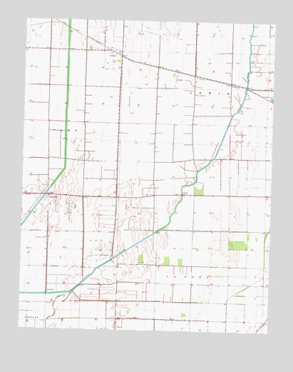
Catron, MO USGS Topographic Map
Click on map above to begin viewing in our Map Viewer.

This topographic map contains these locations and features:
Feature Name Type Latitude Longitude GNIS ID View Map
BadervillePopulated PlaceN36.5545°W89.7370°713525View Map
CatronPopulated PlaceN36.6114°W89.7031°731551View Map
Catron Post OfficePost OfficeN36.6127°W89.7056°2782863View Map
Ditch Number 40CanalN36.5937°W89.7376°737843View Map
Ditch Number 48CanalN36.5267°W89.6765°737844View Map
Ditch Number 52CanalN36.5120°W89.6851°737845View Map
DoddsPopulated PlaceN36.6020°W89.6740°731562View Map
Hondin (historical)Populated PlaceN36.6220°W89.7301°742572View Map
Krepin (historical)Populated PlaceN36.6187°W89.7204°742573View Map
Lone StarPopulated PlaceN36.5153°W89.7367°741024View Map
Main DitchCanalN36.5409°W89.6498°737847View Map
Main Ditch Number 32CanalN36.5048°W89.6795°737846View Map
New Madrid CountyCivilN36.5946°W89.6518°758526View Map
SkyPopulated PlaceN36.6006°W89.6423°738295View Map
Town of CatronCivilN36.6110°W89.7060°2396630View Map
Township of La FontCivilN36.5043°W89.6471°767063View Map
Township of LewisCivilN36.5910°W89.6473°767065View Map
Woodrow Church (historical)ChurchN36.5559°W89.6820°746825View Map

Note: Coordinates in the location and feature list above are referenced to NAD83 datum.


Copyright (C) 2008-2025 Ryan Niemi / Sunset Dynamics ... All Rights Reserved