TopoQuest Logo
Do you find TopoQuest useful?
Help keep TopoQuest running and adding new maps/features by donating!
Bitcoin:  19c7KJd3qBynnjoSw5npx9KScwjBe4ifkT
Litecoin:  LXs6TkuXGGXo1vDsWCkWVdjQX94eUKd6ui
Home View Maps Find Maps Find Places Resources & Links


New Madrid, Missouri Topographic Map

USGS Map Title: New Madrid, MO
USGS Map MRC: 36089E5
DRG (GeoTIFF) Download: o36089e5.tif


Neighboring USGS Topographic Map Quads:


  Charter Oak, MO  
36089F6
 

  Kewanee, MO  
36089F5
 

  Henderson Mound, MO  
36089F4
 

  Catron, MO  
36089E6
 

  New Madrid, MO  
36089E5
 

  Hubbard Lake, MO  
36089E4
 

  Portageville, MO  
36089D6
 

  Point Pleasant, MO  
36089D5
 

  Tiptonville, TN  
36089D4


Map MRC Location:

N37°
W90°
N37°
W89°
H8 H7 H6 H5 H4 H3 H2 H1
G8 G7 G6 G5 G4 G3 G2 G1
F8 F7 F6 F5 F4 F3 F2 F1
E8 E7 E6 E5 E4 E3 E2 E1
D8 D7 D6 D5 D4 D3 D2 D1
C8 C7 C6 C5 C4 C3 C2 C1
B8 B7 B6 B5 B4 B3 B2 B1
A8 A7 A6 A5 A4 A3 A2 A1
N36°
W90°
N36°
W89°

New Madrid, MO USGS 1:24K Topographic Map Preview:
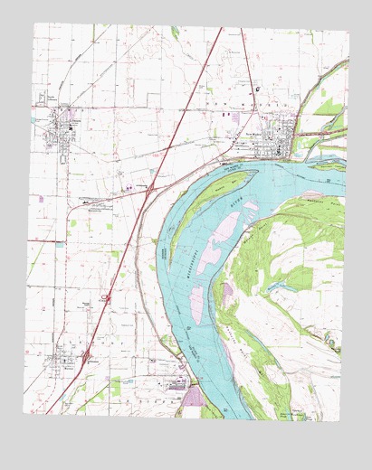
New Madrid, MO USGS Topographic Map
Click on map above to begin viewing in our Map Viewer.

This topographic map contains these locations and features:
Feature Name Type Latitude Longitude GNIS ID View Map
A C LaForge CemeteryCemeteryN36.6123°W89.5087°742577View Map
Baines CemeteryCemeteryN36.5772°W89.5902°713553View Map
Beaver SloughGutN36.5017°W89.5204°486626View Map
City of HowardvilleCivilN36.5685°W89.5971°2394431View Map
City of LilbournCivilN36.5908°W89.6131°2395707View Map
City of MarstonCivilN36.5177°W89.6062°2395026View Map
City of New MadridCivilN36.5878°W89.5504°2395206View Map
Cody (historical)Populated PlaceN36.6106°W89.6095°742574View Map
County Memorial AirportAirportN36.5344°W89.6007°758829View Map
Dawson CemeteryCemeteryN36.5902°W89.5742°716747View Map
Des CyprieGutN36.6206°W89.5681°716849View Map
Dettroy CemeteryCemeteryN36.5649°W89.5894°716854View Map
Evergreen CemeteryCemeteryN36.6076°W89.5373°717687View Map
Ford CemeteryCemeteryN36.6235°W89.5182°718065View Map
Fulton CemeteryCemeteryN36.5347°W89.5884°718291View Map
Hatcher CemeteryCemeteryN36.5872°W89.5557°719202View Map
Haubold CemeteryCemeteryN36.5249°W89.5969°719212View Map
Howard CemeteryCemeteryN36.5984°W89.5379°719907View Map
HowardvillePopulated PlaceN36.5681°W89.6006°719923View Map
Howardville Fire DepartmentBuildingN36.5673°W89.5979°2621527View Map
Howardville Police DepartmentBuildingN36.5674°W89.5979°2752282View Map
Hunter CemeteryCemeteryN36.5980°W89.5294°720007View Map
Hunter-Dawson State ParkParkN36.6139°W89.5315°737849View Map
Indian MoundSummitN36.5720°W89.5884°730303View Map
Kentucky Bend DivisionCivilN36.5393°W89.5175°1937016View Map
Kentucky Point BarBarN36.5184°W89.5362°495677View Map
La Forge CemeteryCemeteryN36.6045°W89.5203°742579View Map
LilbournPopulated PlaceN36.5923°W89.6154°731603View Map
Lilbourn Police DepartmentBuildingN36.5915°W89.6150°2752238View Map
Lilbourn Post OfficePost OfficeN36.5917°W89.6153°2783015View Map
Lilbourn Volunteer Fire DepartmentBuildingN36.5904°W89.6148°2621529View Map
Madrid BarIslandN36.5720°W89.5531°497444View Map
MarstonPopulated PlaceN36.5190°W89.6126°721910View Map
Marston Police DepartmentBuildingN36.5187°W89.6101°2752450View Map
Marston Post OfficePost OfficeN36.5176°W89.6132°2783092View Map
Marston Volunteer Fire DepartmentBuildingN36.5175°W89.6093°2621524View Map
Minner CemeteryCemeteryN36.6057°W89.5594°722441View Map
Missouri Department of Conservation Forestry Southeast Regional Field Fire Office New MadridBuildingN36.5832°W89.5527°2621528View Map
Morrison ChuteStreamN36.5823°W89.5165°722657View Map
Morrison TowheadIslandN36.5817°W89.5029°722660View Map
Mound Church (historical)ChurchN36.5701°W89.5906°730302View Map
Mounds CemeteryCemeteryN36.5712°W89.5898°722702View Map
New Hope CemeteryCemeteryN36.5042°W89.6090°723226View Map
New Hope Church (historical)ChurchN36.5048°W89.6084°730301View Map
New MadridPopulated PlaceN36.5864°W89.5279°723282View Map
New Madrid BendBendN36.5240°W89.5623°738299View Map
New Madrid Bend RevetmentLeveeN36.5626°W89.5712°738298View Map
New Madrid County Sheriff's OfficeBuildingN36.5873°W89.5282°2752428View Map
New Madrid Fire DepartmentBuildingN36.5850°W89.5275°2620389View Map
New Madrid Police DepartmentBuildingN36.5849°W89.5278°2752559View Map
New Madrid Post OfficePost OfficeN36.5861°W89.5260°2782571View Map
New Madrid RevetmentLeveeN36.5826°W89.5306°738297View Map
Newbauer CemeteryCemeteryN36.5292°W89.5874°723329View Map
North LilbournPopulated PlaceN36.6017°W89.6201°723478View Map
OtisPopulated PlaceN36.6134°W89.6034°738296View Map
Powell CemeteryCemeteryN36.5988°W89.5556°724809View Map
Raidt CemeteryCemeteryN36.6246°W89.5103°725069View Map
Reeder CemeteryCemeteryN36.5208°W89.5872°725193View Map
Robbins CemeteryCemeteryN36.5090°W89.5602°725389View Map
Saint Johns BayouStreamN36.5831°W89.5173°725766View Map
Saint Mary School (historical)LocaleN36.6042°W89.5737°742575View Map
Saint Mary School (historical)LocaleN36.6042°W89.5567°742576View Map
Saint Marys CemeteryCemeteryN36.5996°W89.5467°725827View Map
Saint Marys CemeteryCemeteryN36.6173°W89.5495°725828View Map
Sand Hill CemeteryCemeteryN36.5887°W89.5535°726012View Map
Shelby Church (historical)ChurchN36.5328°W89.5834°742580View Map
Shelby School (historical)LocaleN36.5331°W89.5826°742581View Map
Sherwood CemeteryCemeteryN36.6226°W89.5448°726343View Map
SimsLocaleN36.5887°W89.6145°730300View Map
Toneys TowheadAreaN36.5001°W89.5167°517068View Map
Village of North LilbournCivilN36.6018°W89.6220°2399518View Map
Watson LakeLakeN36.5428°W89.5258°506287View Map
Watson PointCapeN36.5606°W89.5365°506290View Map
Wright CemeteryCemeteryN36.6051°W89.5170°742578View Map

Note: Coordinates in the location and feature list above are referenced to NAD83 datum.


Copyright (C) 2008-2024 Ryan Niemi / Sunset Dynamics ... All Rights Reserved