TopoQuest Logo
Do you find TopoQuest useful?
Help keep TopoQuest running and adding new maps/features by donating!
Bitcoin:  19c7KJd3qBynnjoSw5npx9KScwjBe4ifkT
Litecoin:  LXs6TkuXGGXo1vDsWCkWVdjQX94eUKd6ui
Home View Maps Find Maps Find Places Resources & Links


Cedarvale, Texas Topographic Map

USGS Map Title: Cedarvale, TX
USGS Map MRC: 32096E1
DRG (GeoTIFF) Download: o32096e1.tif


Neighboring USGS Topographic Map Quads:


  Elmo, TX  
32096F2
 

  Wills Point, TX  
32096F1
 

  Edgewood, TX  
32095F8
 

  Ola, TX  
32096E2
 

  Cedarvale, TX  
32096E1
 

  Myrtle Springs, TX  
32095E8
 

  Kemp, TX  
32096D2
 

  Prairieville, TX  
32096D1
 

  Phalba, TX  
32095D8


Map MRC Location:

N33°
W97°
N33°
W96°
H8 H7 H6 H5 H4 H3 H2 H1
G8 G7 G6 G5 G4 G3 G2 G1
F8 F7 F6 F5 F4 F3 F2 F1
E8 E7 E6 E5 E4 E3 E2 E1
D8 D7 D6 D5 D4 D3 D2 D1
C8 C7 C6 C5 C4 C3 C2 C1
B8 B7 B6 B5 B4 B3 B2 B1
A8 A7 A6 A5 A4 A3 A2 A1
N32°
W97°
N32°
W96°

Cedarvale, TX USGS 1:24K Topographic Map Preview:
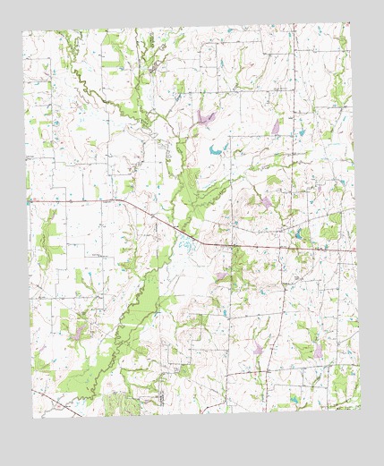
Cedarvale, TX USGS Topographic Map
Click on map above to begin viewing in our Map Viewer.

This topographic map contains these locations and features:
Feature Name Type Latitude Longitude GNIS ID View Map
Allen CreekStreamN32.5926°W96.0769°1329388View Map
Bobbitt LakeReservoirN32.5835°W96.0502°1859820View Map
Bobbitt Lake DamDamN32.5835°W96.0502°1859819View Map
Brewer CemeteryCemeteryN32.5076°W96.0939°1331232View Map
CanaPopulated PlaceN32.5746°W96.0147°1378088View Map
Caney CreekStreamN32.5437°W96.0808°1332089View Map
CedarvalePopulated PlaceN32.5699°W96.0916°1378105View Map
Fairview Community CenterLocaleN32.6040°W96.0297°1335645View Map
Field CemeteryCemeteryN32.5146°W96.0686°1335767View Map
Flat CreekStreamN32.5815°W96.0116°1335902View Map
Goode FieldAirportN32.5127°W96.0021°1386340View Map
Heidle CemeteryCemeteryN32.5812°W96.0822°1337562View Map
Kayser CemeteryCemeteryN32.5335°W96.1055°1338971View Map
Massey BranchStreamN32.5879°W96.0652°1341056View Map
Muddy Cedar CreekStreamN32.6171°W96.1036°1342218View Map
North Bouie ChurchChurchN32.5837°W96.1250°1342692View Map
Rocky Cedar CreekStreamN32.6173°W96.1045°1345440View Map
ScottPopulated PlaceN32.5946°W96.0222°1379040View Map
Soil Conservation Service Site 109 DamDamN32.5901°W96.0302°1859811View Map
Soil Conservation Service Site 109 ReservoirReservoirN32.5901°W96.0302°1859812View Map
Soil Conservation Service Site 110 DamDamN32.5951°W96.0586°1859813View Map
Soil Conservation Service Site 110 ReservoirReservoirN32.5951°W96.0586°1859814View Map
Soil Conservation Service Site 113 DamDamN32.5685°W96.0352°1859815View Map
Soil Conservation Service Site 113 ReservoirReservoirN32.5685°W96.0352°1859816View Map
Soil Conservation Service Site 114 DamDamN32.5435°W96.0536°1859817View Map
Soil Conservation Service Site 114 ReservoirReservoirN32.5435°W96.0536°1859818View Map
Soil Conservation Service Site 117 DamDamN32.5251°W96.1069°1863038View Map
Soil Conservation Service Site 117 ReservoirReservoirN32.5251°W96.1069°1863039View Map
Soil Conservation Service Site 128 DamDamN32.5168°W96.0152°1859807View Map
Soil Conservation Service Site 128 ReservoirReservoirN32.5168°W96.0152°1859808View Map
Soil Conservation Service Site 129 DamDamN32.5185°W96.0386°1859809View Map
Soil Conservation Service Site 129 ReservoirReservoirN32.5185°W96.0386°1859810View Map
South Bouie ChurchChurchN32.5518°W96.0969°1347412View Map
Van Zandt County Constable's Office Precinct 2BuildingN32.5636°W96.0066°2751526View Map
WatkinsPopulated PlaceN32.5396°W96.0277°1379243View Map
Wesley ChapelChurchN32.5429°W96.0219°1349661View Map
WisePopulated PlaceN32.5135°W96.0352°1379289View Map
Wolf CreekStreamN32.6079°W96.0800°1350467View Map

Note: Coordinates in the location and feature list above are referenced to NAD83 datum.


Copyright (C) 2008-2025 Ryan Niemi / Sunset Dynamics ... All Rights Reserved