TopoQuest Logo
Do you find TopoQuest useful?
Help keep TopoQuest running and adding new maps/features by donating!
Bitcoin:  19c7KJd3qBynnjoSw5npx9KScwjBe4ifkT
Litecoin:  LXs6TkuXGGXo1vDsWCkWVdjQX94eUKd6ui
Home View Maps Find Maps Find Places Resources & Links


Chain Lake, Wisconsin Topographic Map

USGS Map Title: Chain Lake, WI
USGS Map MRC: 45091C4
DRG (GeoTIFF) Download: o45091c4.tif


Neighboring USGS Topographic Map Quads:


  Strickland, WI  
45091D5
 

  Weyerhaeuser, WI  
45091D4
 

  Bruce, WI  
45091D3
 

  Moose Ear Lake, WI  
45091C5
 

  Chain Lake, WI  
45091C4
 

  Fireside Lakes, WI  
45091C3
 

  New Auburn, WI  
45091B5
 

  Marsh-Miller Lake, WI  
45091B4
 

  Bob Lake, WI  
45091B3


Map MRC Location:

N46°
W92°
N46°
W91°
H8 H7 H6 H5 H4 H3 H2 H1
G8 G7 G6 G5 G4 G3 G2 G1
F8 F7 F6 F5 F4 F3 F2 F1
E8 E7 E6 E5 E4 E3 E2 E1
D8 D7 D6 D5 D4 D3 D2 D1
C8 C7 C6 C5 C4 C3 C2 C1
B8 B7 B6 B5 B4 B3 B2 B1
A8 A7 A6 A5 A4 A3 A2 A1
N45°
W92°
N45°
W91°

Chain Lake, WI USGS 1:24K Topographic Map Preview:
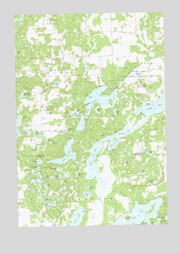
Chain Lake, WI USGS Topographic Map
Click on map above to begin viewing in our Map Viewer.

This topographic map contains these locations and features:
Feature Name Type Latitude Longitude GNIS ID View Map
Atwood LakeLakeN45.3169°W91.4740°1561002View Map
Axhandle LakeLakeN45.2779°W91.4831°1561041View Map
Bass LakeLakeN45.2629°W91.4718°1561236View Map
Bear LakeLakeN45.3036°W91.4793°1561382View Map
Bear LakeLocaleN45.3094°W91.4793°1561390View Map
Bear Lake School (historical)SchoolN45.3136°W91.4788°1867762View Map
Beauty LakeLakeN45.3523°W91.4998°1561418View Map
Brush LakeLakeN45.3169°W91.4175°1562308View Map
Cadotte LakeLakeN45.2917°W91.3896°1562503View Map
Calkins LakeLakeN45.2683°W91.4419°1562517View Map
Camp WahdoonLocaleN45.3311°W91.4927°1562670View Map
Cather LakeLakeN45.2789°W91.4708°1562809View Map
Cedar CreekStreamN45.2805°W91.4327°1562836View Map
Cedar CreekStreamN45.2630°W91.3790°1562840View Map
Chain LakeLakeN45.2914°W91.4368°1562922View Map
Chain Lake School (historical)SchoolN45.2775°W91.4499°1842802View Map
Chick LakeLakeN45.2794°W91.4642°1563007View Map
Clear LakeLakeN45.2977°W91.4185°1563151View Map
Coon LakeLakeN45.3011°W91.4855°1563369View Map
Dark LakeLakeN45.2738°W91.4764°1563715View Map
Dead Goose LakeLakeN45.3283°W91.4939°1563766View Map
Dickey LakeLakeN45.3056°W91.4900°1563971View Map
Galky LakeLakeN45.3321°W91.3944°1565383View Map
Granger LakeLakeN45.2723°W91.4419°1565731View Map
Hogskin LakeLakeN45.2957°W91.4823°1566530View Map
Hungry LakeLakeN45.3167°W91.4319°1566803View Map
Jacks LakeLakeN45.2819°W91.3972°1567061View Map
Lake FourLakeN45.3152°W91.4488°1565187View Map
Lake OneLakeN45.3147°W91.4572°1570826View Map
Lake ThreeLakeN45.3158°W91.4496°1575414View Map
Lake TwoLakeN45.3166°W91.4548°1575832View Map
Leo Joerg LakeLakeN45.2753°W91.3850°1567976View Map
Little Bass LakeLakeN45.2646°W91.4775°1568174View Map
Little Bear LakeLakeN45.3011°W91.4752°1568191View Map
Little Pine LakeLakeN45.2841°W91.4825°1568358View Map
Long LakeLakeN45.2512°W91.4019°1568582View Map
Long Lake School (historical)SchoolN45.2541°W91.4138°1842867View Map
Lost LakeLakeN45.2865°W91.4101°1568657View Map
MacDonald LakeLakeN45.3186°W91.4763°1568858View Map
Mathy LakeLakeN45.3571°W91.3797°1569123View Map
McCann LakeLakeN45.3047°W91.4085°1569171View Map
McDermott CreekStreamN45.3302°W91.4329°1569194View Map
McDonald LakeLakeN45.2834°W91.4652°1569203View Map
Morris-Erickson County ParkParkN45.2533°W91.4088°1569751View Map
Muskrat LakeLakeN45.3141°W91.4977°1570073View Map
North Cummings LakeLakeN45.3716°W91.4725°1570416View Map
North Lima School (historical)SchoolN45.3347°W91.3921°1867820View Map
Pine LakeLakeN45.2924°W91.4590°1571491View Map
Potato Creek FlowageLakeN45.3391°W91.3996°1571828View Map
Potato Creek State Wildlife Management AreaParkN45.3366°W91.4002°1571829View Map
Potato LakeLakeN45.3239°W91.4318°1571831View Map
Rock LakeLakeN45.2992°W91.4714°1572456View Map
Round LakeLakeN45.2542°W91.4509°1572673View Map
Ruby LakeLakeN45.2722°W91.4622°1572705View Map
Rusk Farm School (historical)SchoolN45.3389°W91.4785°1867841View Map
Rusk LakeLakeN45.3417°W91.4736°1572749View Map
Rusk TownhallBuildingN45.3136°W91.4788°1867842View Map
Schoolhouse LakeLakeN45.2802°W91.4505°1573815View Map
Silver LakeLakeN45.2881°W91.4812°1574141View Map
South Cummings LakeLakeN45.3691°W91.4722°1574430View Map
Stang Lookout TowerTowerN45.2850°W91.4715°1581346View Map
Star LakeLakeN45.3058°W91.4852°1574806View Map
Sugar LakeLakeN45.3340°W91.4657°1575027View Map
Tamarack LakeLakeN45.2516°W91.3830°1575241View Map
The NarrowsChannelN45.3144°W91.4429°1575330View Map
Town of RuskCivilN45.3351°W91.4798°1584079View Map
Turk LakeLakeN45.2764°W91.4630°1575721View Map
Two Bear CampLocaleN45.3650°W91.4952°1575823View Map
Two Bear LakeLakeN45.3726°W91.4937°1575824View Map
Whiplash LakeLakeN45.3056°W91.4577°1576609View Map

Note: Coordinates in the location and feature list above are referenced to NAD83 datum.


Copyright (C) 2008-2024 Ryan Niemi / Sunset Dynamics ... All Rights Reserved