TopoQuest Logo
Do you find TopoQuest useful?
Help keep TopoQuest running and adding new maps/features by donating!
Bitcoin:  19c7KJd3qBynnjoSw5npx9KScwjBe4ifkT
Litecoin:  LXs6TkuXGGXo1vDsWCkWVdjQX94eUKd6ui
Home View Maps Find Maps Find Places Resources & Links


Chandler, Texas Topographic Map

USGS Map Title: Chandler, TX
USGS Map MRC: 32095C4
DRG (GeoTIFF) Download: o32095c4.tif


Neighboring USGS Topographic Map Quads:


  Carroll, TX  
32095D5
 

  Mount Sylvan, TX  
32095D4
 

  Tyler North, TX  
32095D3
 

  Brownsboro, TX  
32095C5
 

  Chandler, TX  
32095C4
 

  Tyler South, TX  
32095C3
 

  Moore Station, TX  
32095B5
 

  Saline Bay, TX  
32095B4
 

  Bullard, TX  
32095B3


Map MRC Location:

N33°
W96°
N33°
W95°
H8 H7 H6 H5 H4 H3 H2 H1
G8 G7 G6 G5 G4 G3 G2 G1
F8 F7 F6 F5 F4 F3 F2 F1
E8 E7 E6 E5 E4 E3 E2 E1
D8 D7 D6 D5 D4 D3 D2 D1
C8 C7 C6 C5 C4 C3 C2 C1
B8 B7 B6 B5 B4 B3 B2 B1
A8 A7 A6 A5 A4 A3 A2 A1
N32°
W96°
N32°
W95°

Chandler, TX USGS 1:24K Topographic Map Preview:
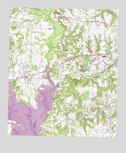
Chandler, TX USGS Topographic Map
Click on map above to begin viewing in our Map Viewer.

This topographic map contains these locations and features:
Feature Name Type Latitude Longitude GNIS ID View Map
Butler CreekStreamN32.2815°W95.4486°1331747View Map
ChandlerPopulated PlaceN32.3079°W95.4800°1332643View Map
Chandler City HallBuildingN32.3108°W95.4693°2753388View Map
Chandler Elementary SchoolSchoolN32.3096°W95.4802°2006546View Map
Chandler Police DepartmentBuildingN32.3108°W95.4692°2751225View Map
Chandler Post OfficePost OfficeN32.3080°W95.4764°2731584View Map
Chandler Volunteer Fire DepartmentBuildingN32.3017°W95.4832°2655180View Map
Church of ChristChurchN32.3199°W95.3950°2023477View Map
City of ChandlerCivilN32.3065°W95.4781°2409435View Map
Club Thirteen DamDamN32.2802°W95.4186°1854733View Map
Club Thirteen LakeReservoirN32.2821°W95.4174°1333012View Map
Concord ChurchChurchN32.3490°W95.4991°1333214View Map
County-Line ChurchChurchN32.3710°W95.4938°1333526View Map
Dean ChurchChurchN32.3143°W95.4080°1334162View Map
Dixie ChurchChurchN32.3626°W95.3988°1334411View Map
Dixie SchoolSchoolN32.3585°W95.3902°1334412View Map
Faith Baptist ChurchChurchN32.3054°W95.4800°2021040View Map
Faith ChurchChurchN32.2577°W95.3847°1335652View Map
GalileePopulated PlaceN32.2663°W95.4286°1378339View Map
Greenbriar Lake DamDamN32.3201°W95.3752°1854725View Map
Henderson County Constable's Office Precinct 3BuildingN32.3085°W95.4797°2751471View Map
Hidden Hill DamDamN32.3318°W95.3852°1854741View Map
Hidden Hill LakeReservoirN32.3342°W95.3865°1854742View Map
Hill LakeReservoirN32.3440°W95.3861°1337783View Map
Holiness ChurchChurchN32.2774°W95.3938°1337940View Map
Hudson J CemeteryCemeteryN32.3440°W95.3863°1338219View Map
Indian CreekStreamN32.2982°W95.4472°1338416View Map
Kickapoo CreekStreamN32.2549°W95.4691°1374364View Map
Lake PlacidReservoirN32.2741°W95.3941°1344156View Map
Lake Placid DamDamN32.2768°W95.3936°1854735View Map
Lost Pine LakeReservoirN32.3182°W95.4126°1340645View Map
Lost Pine Lake DamDamN32.3151°W95.4152°1854737View Map
Macedonia CemeteryCemeteryN32.3188°W95.4847°1340795View Map
Martin Spring BranchStreamN32.2757°W95.4980°1374811View Map
Noonday Assembly of God ChurchChurchN32.2668°W95.3777°2023541View Map
Noonday Baptist ChurchChurchN32.2579°W95.3900°2023458View Map
Peveto DamDamN32.3451°W95.4419°1854739View Map
Peveto LakeReservoirN32.3449°W95.4395°1854740View Map
Pleasant Retreat Acres DamDamN32.3318°W95.4052°1854743View Map
Pleasant Retreat Acres LakeReservoirN32.3318°W95.4052°1854744View Map
Pleasant Retreat CemeteryCemeteryN32.3440°W95.3977°1344237View Map
Pleasant Retreat United Methodist ChurchChurchN32.3618°W95.3919°2023394View Map
Prairie CreekStreamN32.3682°W95.4563°1344493View Map
Sevenleague CemeteryCemeteryN32.2540°W95.4261°1346914View Map
Smith County Constable - Precinct 2BuildingN32.2567°W95.3848°2751198View Map
Spring Hill ChurchChurchN32.2804°W95.3891°1347739View Map
Taylor CreekStreamN32.2757°W95.4175°1348288View Map
Tyler Army Air Field (historical)MilitaryN32.3558°W95.3989°2096588View Map
Tyler Fire Department Station 3BuildingN32.3606°W95.4014°2655303View Map
Tyler Pounds Regional AirportAirportN32.3588°W95.3991°1387657View Map
Tyler Sports ComplexParkN32.3110°W95.3761°2028197View Map

Note: Coordinates in the location and feature list above are referenced to NAD83 datum.


Copyright (C) 2008-2024 Ryan Niemi / Sunset Dynamics ... All Rights Reserved