TopoQuest Logo
Do you find TopoQuest useful?
Help keep TopoQuest running and adding new maps/features by donating!
Bitcoin:  19c7KJd3qBynnjoSw5npx9KScwjBe4ifkT
Litecoin:  LXs6TkuXGGXo1vDsWCkWVdjQX94eUKd6ui
Home View Maps Find Maps Find Places Resources & Links


Check, Virginia Topographic Map

USGS Map Title: Check, VA
USGS Map MRC: 37080A2
DRG (GeoTIFF) Download: o37080a2.tif


Neighboring USGS Topographic Map Quads:


  Ironto, VA  
37080B3
 

  Elliston, VA  
37080B2
 

  Bent Mountain, VA  
37080B1
 

  Pilot, VA  
37080A3
 

  Check, VA  
37080A2
 

  Callaway, VA  
37080A1
 

  Floyd, VA  
36080H3
 

  Endicott, VA  
36080H2
 

  Ferrum, VA  
36080H1


Map MRC Location:

N38°
W81°
N38°
W80°
H8 H7 H6 H5 H4 H3 H2 H1
G8 G7 G6 G5 G4 G3 G2 G1
F8 F7 F6 F5 F4 F3 F2 F1
E8 E7 E6 E5 E4 E3 E2 E1
D8 D7 D6 D5 D4 D3 D2 D1
C8 C7 C6 C5 C4 C3 C2 C1
B8 B7 B6 B5 B4 B3 B2 B1
A8 A7 A6 A5 A4 A3 A2 A1
N37°
W81°
N37°
W80°

Check, VA USGS 1:24K Topographic Map Preview:
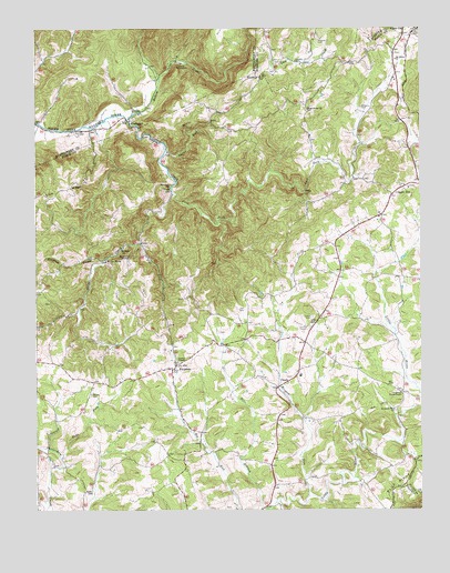
Check, VA USGS Topographic Map
Click on map above to begin viewing in our Map Viewer.

This topographic map contains these locations and features:
Feature Name Type Latitude Longitude GNIS ID View Map
Bottom CreekStreamN37.1018°W80.2200°1463693View Map
Camp CreekStreamN37.1171°W80.1812°1464317View Map
Camp KiwaniannaLocaleN37.1160°W80.2020°1464338View Map
CheckLocaleN37.0349°W80.1656°1464762View Map
Check Elementary SchoolSchoolN37.0347°W80.1643°1494348View Map
Check Post OfficePost OfficeN37.0303°W80.1705°2766175View Map
Christo ChurchChurchN37.1168°W80.1650°1464897View Map
Copper HillPopulated PlaceN37.0818°W80.1342°1477224View Map
Copper Hill Church of the BrethrenChurchN37.0835°W80.1289°1494350View Map
Copper Hill Post OfficePost OfficeN37.0762°W80.1379°2766185View Map
Crossroads Union ChapelChurchN37.0307°W80.1314°1465484View Map
Flat RunStreamN37.0690°W80.2156°1466658View Map
Floyd County Emergency Medical Services Station 3BuildingN37.0351°W80.2124°2721179View Map
Floyd County Volunteer Fire Department 3BuildingN37.0312°W80.2050°2721091View Map
Goose CreekStreamN37.1018°W80.2203°1467252View Map
Griffith CreekStreamN37.0649°W80.2278°1467545View Map
Halls CemeteryCemeteryN37.0362°W80.2056°1467672View Map
Head of the River ChurchChurchN37.0493°W80.1595°1494363View Map
HemlockPopulated PlaceN37.0693°W80.2156°1494364View Map
Hemlock ChurchChurchN37.0843°W80.2062°1467912View Map
Kefauver CemeteryCemeteryN37.1046°W80.1439°1468927View Map
Lick ForkStreamN37.0826°W80.2050°1469398View Map
Locust Grove DistrictCivilN37.0478°W80.1815°1927379View Map
Meadow RunStreamN37.0037°W80.1617°1470316View Map
Mount Olivet ChurchChurchN37.1171°W80.1328°1471000View Map
PiedmontPopulated PlaceN37.1001°W80.2189°1472274View Map
Piedmont Camp Meeting Grounds Historic DistrictParkN37.1037°W80.2164°1674679View Map
Pine BranchStreamN37.0004°W80.1756°1472328View Map
Pine Forest ChurchChurchN37.1040°W80.1612°1472340View Map
Pine ForkStreamN37.0135°W80.2420°1472341View Map
Poff CemeteryCemeteryN37.0521°W80.1820°1472552View Map
Saint Pauls ChurchChurchN37.0676°W80.2220°1473873View Map
Salem CemeteryCemeteryN37.0501°W80.1600°1473932View Map
Simpson CemeteryCemeteryN37.1221°W80.1578°1474614View Map
SimpsonsPopulated PlaceN37.0379°W80.2045°1474618View Map
Simpsons MissionChurchN37.0657°W80.2192°1474620View Map
Smiths ChapelChurchN37.0387°W80.2039°1474783View Map
Sugar RunStreamN37.0935°W80.2075°1475287View Map
Tices Mill (historical)LocaleN37.0999°W80.2337°1674759View Map
Willis StoreLocaleN37.0660°W80.2270°1476788View Map
Wilson CemeteryCemeteryN37.0301°W80.2323°1476812View Map

Note: Coordinates in the location and feature list above are referenced to NAD83 datum.


Copyright (C) 2008-2024 Ryan Niemi / Sunset Dynamics ... All Rights Reserved