TopoQuest Logo
Do you find TopoQuest useful?
Help keep TopoQuest running and adding new maps/features by donating!
Bitcoin:  19c7KJd3qBynnjoSw5npx9KScwjBe4ifkT
Litecoin:  LXs6TkuXGGXo1vDsWCkWVdjQX94eUKd6ui
Home View Maps Find Maps Find Places Resources & Links


Callaway, Virginia Topographic Map

USGS Map Title: Callaway, VA
USGS Map MRC: 37080A1
DRG (GeoTIFF) Download: o37080a1.tif


Neighboring USGS Topographic Map Quads:


  Elliston, VA  
37080B2
 

  Bent Mountain, VA  
37080B1
 

  Garden City, VA  
37079B8
 

  Check, VA  
37080A2
 

  Callaway, VA  
37080A1
 

  Boones Mill, VA  
37079A8
 

  Endicott, VA  
36080H2
 

  Ferrum, VA  
36080H1
 

  Rocky Mount, VA  
36079H8


Map MRC Location:

N38°
W81°
N38°
W80°
H8 H7 H6 H5 H4 H3 H2 H1
G8 G7 G6 G5 G4 G3 G2 G1
F8 F7 F6 F5 F4 F3 F2 F1
E8 E7 E6 E5 E4 E3 E2 E1
D8 D7 D6 D5 D4 D3 D2 D1
C8 C7 C6 C5 C4 C3 C2 C1
B8 B7 B6 B5 B4 B3 B2 B1
A8 A7 A6 A5 A4 A3 A2 A1
N37°
W81°
N37°
W80°

Callaway, VA USGS 1:24K Topographic Map Preview:
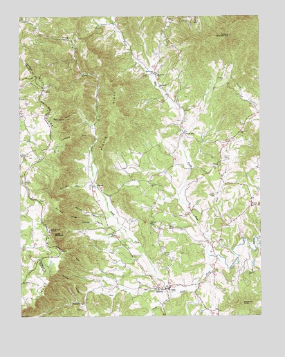
Callaway, VA USGS Topographic Map
Click on map above to begin viewing in our Map Viewer.

This topographic map contains these locations and features:
Feature Name Type Latitude Longitude GNIS ID View Map
Adney Gap CemeteryCemeteryN37.1157°W80.0986°1791023View Map
Adney Gap ChurchChurchN37.1157°W80.0987°1462374View Map
AlgomaPopulated PlaceN37.0560°W80.0873°1492457View Map
Angell CemeteryCemeteryN37.0360°W80.0417°1791027View Map
Balcony ChurchChurchN37.0546°W80.0564°1462708View Map
Beat Rock HollowValleyN37.0849°W80.0941°1462917View Map
Beckner CemeteryCemeteryN37.0262°W80.0761°1462984View Map
Bethany ChurchChurchN37.0387°W80.0573°1463124View Map
Blackwater ChurchChurchN37.0960°W80.0517°1463531View Map
Blackwater DistrictCivilN37.0443°W80.0223°1927099View Map
Blackwater River Number Four DamDamN37.0771°W80.0365°1489801View Map
Blackwater River Number Six DamDamN37.0358°W80.0263°1489800View Map
Bowman CemeteryCemeteryN37.0657°W80.0181°1463718View Map
Bowman CemeteryCemeteryN37.0987°W80.0184°1463719View Map
Bush RunStreamN37.0332°W80.0267°1464166View Map
Cahas MountainSummitN37.1174°W80.0156°1464237View Map
Cahas OverlookLocaleN37.0943°W80.1117°1464238View Map
CallawayPopulated PlaceN37.0115°W80.0495°1492693View Map
Callaway ChurchChurchN37.0332°W80.0764°1464260View Map
Callaway Elementary SchoolSchoolN37.0118°W80.0477°1494402View Map
Callaway Post OfficePost OfficeN37.0125°W80.0381°2766168View Map
Callaway Volunteer Fire Department and Rescue Squad Company 5BuildingN37.0125°W80.0480°2086292View Map
Castle View CemeteryCemeteryN37.0368°W80.0464°1791050View Map
Castle View ChurchChurchN37.0371°W80.0467°1791049View Map
Cooper HollowValleyN37.0396°W80.0867°1465223View Map
Daniels RunStreamN37.0121°W80.0489°1465596View Map
Devils BackboneRidgeN37.0343°W80.1073°1465740View Map
Devils Backbone OverlookLocaleN37.0362°W80.1095°1465742View Map
Dillons MillPopulated PlaceN37.0762°W80.0392°1477265View Map
Fairmont CemeteryCemeteryN37.0621°W80.0220°1494426View Map
Fairmont ChurchChurchN37.0626°W80.0214°1466398View Map
Graveyard KnobSummitN37.0051°W80.0100°1493022View Map
Green CreekStreamN37.0537°W80.0845°1467466View Map
Guerrant-Calloway CemeteryCemeteryN37.0482°W80.0848°1791074View Map
Holland CemeteryCemeteryN37.0201°W80.0484°1791080View Map
Hollands CemeteryCemeteryN37.0257°W80.0503°1468138View Map
Jamison-Prillaman CemeteryCemeteryN37.0282°W80.0684°1791083View Map
Johnson-Mills CemeteryCemeteryN37.0332°W80.0773°1791087View Map
Junta (historical)Populated PlaceN37.0332°W80.0531°1496471View Map
King CemeteryCemeteryN37.0485°W80.1145°1791090View Map
Logan-Holland CemeteryCemeteryN37.0257°W80.0498°1791091View Map
Middle RidgeRidgeN37.0799°W80.0756°1470414View Map
Miller CemeteryCemeteryN37.0279°W80.0523°1791099View Map
Monte Vista CemeteryCemeteryN37.1021°W80.0531°1791101View Map
Monte Vista ChurchChurchN37.1012°W80.0545°1470687View Map
Monte Vista SchoolSchoolN37.1004°W80.0525°1470688View Map
Nearway RidgeRidgeN37.0146°W80.0978°1471355View Map
Nichols CemeteryCemeteryN37.0668°W80.1239°1471534View Map
North Fork Blackwater RiverStreamN37.0251°W80.0264°1471596View Map
Piedmont CemeteryCemeteryN37.0121°W80.0531°1494485View Map
Piedmont ChurchChurchN37.0118°W80.0528°1472275View Map
Pine SpurRidgeN37.0249°W80.0964°1472370View Map
Pine Spur GapGapN37.0426°W80.1137°1496472View Map
Pine Spur OverlookLocaleN37.0276°W80.1039°1472371View Map
Pippin Hill ChurchChurchN37.1015°W80.0909°1472437View Map
Prices CemeteryCemeteryN37.0360°W80.0923°1472789View Map
Prillaman CemeteryCemeteryN37.0110°W80.0606°1791118View Map
RetreatLocaleN37.0460°W80.0045°1473153View Map
Richards CemeteryCemeteryN37.0040°W80.0936°1791120View Map
Roaring RunStreamN37.0537°W80.0845°1473305View Map
Round Hill CemeteryCemeteryN37.0760°W80.0098°1473577View Map
Snuffers RidgeRidgeN37.0429°W80.1014°1474818View Map
South Fork Blackwater RiverStreamN37.0251°W80.0264°1474848View Map
Stanley CemeteryCemeteryN37.0176°W80.0064°1475066View Map
Toney CemeteryCemeteryN37.0788°W80.0302°2680231View Map
Via CemeteryCemeteryN37.0262°W80.0409°1791134View Map
Wades GapGapN37.1246°W80.0342°1476212View Map
Waldron-Bowles CemeteryCemeteryN37.0629°W80.0889°1791135View Map
Walnut HollowValleyN37.0404°W80.0845°1476283View Map
Walters CemeteryCemeteryN37.0279°W80.0514°1476293View Map
Watson CemeteryCemeteryN37.0368°W80.0531°1476387View Map
Webb CemeteryCemeteryN37.0029°W80.0923°1476423View Map
Webster CemeteryCemeteryN37.1207°W80.0478°1791136View Map
Webster-Wyatt CemeteryCemeteryN37.0679°W80.0631°1791138View Map
Wilson CemeteryCemeteryN37.0562°W80.1223°1476813View Map
Wilson CemeteryCemeteryN37.0890°W80.1217°1476814View Map
Wimmers CemeteryCemeteryN37.0690°W80.1073°1476838View Map
Wimmers SpurRidgeN37.0754°W80.0959°1476839View Map
WROV-FM (Martinsville)TowerN37.1168°W80.0159°1498999View Map

Note: Coordinates in the location and feature list above are referenced to NAD83 datum.


Copyright (C) 2008-2025 Ryan Niemi / Sunset Dynamics ... All Rights Reserved