TopoQuest Logo
Do you find TopoQuest useful?
Help keep TopoQuest running and adding new maps/features by donating!
Bitcoin:  19c7KJd3qBynnjoSw5npx9KScwjBe4ifkT
Litecoin:  LXs6TkuXGGXo1vDsWCkWVdjQX94eUKd6ui
Home View Maps Find Maps Find Places Resources & Links


Chelsea, Alabama Topographic Map

USGS Map Title: Chelsea, AL
USGS Map MRC: 33086C6
DRG (GeoTIFF) Download: o33086c6.tif


Neighboring USGS Topographic Map Quads:


  Birmingham South, AL  
33086D7
 

  Cahaba Heights, AL  
33086D6
 

  Vandiver, AL  
33086D5
 

  Helena, AL  
33086C7
 

  Chelsea, AL  
33086C6
 

  Westover, AL  
33086C5
 

  Alabaster, AL  
33086B7
 

  Bounds Lake, AL  
33086B6
 

  Columbiana, AL  
33086B5


Map MRC Location:

N34°
W87°
N34°
W86°
H8 H7 H6 H5 H4 H3 H2 H1
G8 G7 G6 G5 G4 G3 G2 G1
F8 F7 F6 F5 F4 F3 F2 F1
E8 E7 E6 E5 E4 E3 E2 E1
D8 D7 D6 D5 D4 D3 D2 D1
C8 C7 C6 C5 C4 C3 C2 C1
B8 B7 B6 B5 B4 B3 B2 B1
A8 A7 A6 A5 A4 A3 A2 A1
N33°
W87°
N33°
W86°

Chelsea, AL USGS 1:24K Topographic Map Preview:
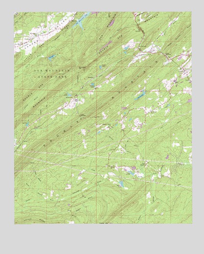
Chelsea, AL USGS Topographic Map
Click on map above to begin viewing in our Map Viewer.

This topographic map contains these locations and features:
Feature Name Type Latitude Longitude GNIS ID View Map
Allen CemeteryCemeteryN33.3743°W86.7069°113001View Map
Allen ChurchChurchN33.3737°W86.7072°146348View Map
Bailey CemeteryCemeteryN33.3720°W86.7497°113349View Map
Beech BranchStreamN33.2646°W86.7289°113810View Map
Belcher LakeReservoirN33.3426°W86.6891°113839View Map
Belcher Lake DamDamN33.3418°W86.6900°131460View Map
Belcher Lumber Company DamDamN33.3684°W86.6800°131487View Map
Big NarrowsGapN33.3648°W86.6600°114303View Map
Bolivar CreekStreamN33.2787°W86.6575°114697View Map
Boyden LakeLakeN33.2737°W86.6745°114792View Map
Boyden Lake DamDamN33.2751°W86.6750°131371View Map
Brown BranchStreamN33.2693°W86.7342°114979View Map
Cahaba Valley Fire Station 185 Ambulance ServiceBuildingN33.3700°W86.6656°2682814View Map
Calvary ChurchChurchN33.2840°W86.6817°157908View Map
Catfish LakeReservoirN33.3684°W86.6810°131486View Map
Cave Spring School (historical)SchoolN33.3154°W86.6544°146385View Map
Charob LakeLakeN33.3259°W86.6602°115974View Map
Charob Lake DamDamN33.3268°W86.6583°131439View Map
ChelseaPopulated PlaceN33.3401°W86.6303°115991View Map
Chelsea City HallBuildingN33.3475°W86.6312°2629398View Map
Chelsea Fire and Rescue Station 1BuildingN33.3498°W86.6304°2683012View Map
Chelsea Fire and Rescue Station 2BuildingN33.2945°W86.6626°2683365View Map
Chelsea High SchoolSchoolN33.3343°W86.6369°115994View Map
Chelsea Post OfficePost OfficeN33.3490°W86.6317°1805567View Map
City of ChelseaCivilN33.3258°W86.6291°2404037View Map
City of Indian Springs VillageCivilN33.3590°W86.7493°2404759View Map
Coalville (historical)LocaleN33.3209°W86.6458°146396View Map
Cooper BranchStreamN33.3521°W86.6567°116569View Map
Debuys Lake DamDamN33.2784°W86.6667°131378View Map
Double MountainRidgeN33.3207°W86.6853°117423View Map
Double Mountain BranchStreamN33.3504°W86.6450°117424View Map
Double Oak Mountain Lake DamDamN33.3568°W86.6817°131472View Map
East SaginawPopulated PlaceN33.2854°W86.6575°156293View Map
Heardmont ParkParkN33.3684°W86.7126°2629397View Map
Ivy BranchStreamN33.3682°W86.6625°120729View Map
K Springs CemeteryCemeteryN33.3168°W86.6536°146484View Map
K Springs ChurchChurchN33.3168°W86.6542°146485View Map
K Springs ChurchChurchN33.3162°W86.6536°151932View Map
Lake ByramLakeN33.2800°W86.6675°115339View Map
Lake GizellaLakeN33.3262°W86.7114°119010View Map
Lake WarrenReservoirN33.3088°W86.7407°128590View Map
Lake Warren DamDamN33.3084°W86.7400°131423View Map
Lenora LakeLakeN33.3321°W86.6944°152021View Map
Liberty Baptist ChurchChurchN33.3340°W86.6253°121548View Map
Liberty CemeteryCemeteryN33.3343°W86.6266°149340View Map
Lime BranchStreamN33.2934°W86.6719°121633View Map
Little NarrowsGapN33.3137°W86.7039°121828View Map
Little NarrowsGapN33.3496°W86.6433°121829View Map
Locust RidgeRidgeN33.2515°W86.7467°121957View Map
Morris BridgeBridgeN33.2787°W86.6528°146518View Map
Mose Davis CemeteryCemeteryN33.2521°W86.6325°146521View Map
Mount Calvary CemeteryCemeteryN33.2843°W86.6811°146523View Map
Mountain Chapel Calvary (historical)ChurchN33.2782°W86.7072°146526View Map
New HopePopulated PlaceN33.3593°W86.7372°123782View Map
New Hope ChurchChurchN33.3565°W86.7442°123828View Map
New Hope Church (historical)ChurchN33.3609°W86.7355°146534View Map
New Hope SchoolSchoolN33.3615°W86.7333°123850View Map
North Shelby County Fire and Emergency Medical District Station 2BuildingN33.3604°W86.7371°2683099View Map
Oak Mountain LakeReservoirN33.3704°W86.7021°152745View Map
Oak Mountain Lake Dam Number OneDamN33.3701°W86.7050°131490View Map
Oak Mountain Old Lake DamDamN33.3468°W86.7250°131463View Map
Oak Mountain State ParkParkN33.3429°W86.7211°124124View Map
Odess Lake DamDamN33.3334°W86.6950°131450View Map
Old Acton CemeteryCemeteryN33.3693°W86.7430°149346View Map
Old LakeReservoirN33.3483°W86.7237°152782View Map
Peavine BranchStreamN33.2940°W86.7492°124555View Map
Pelham Fire Department Station 5BuildingN33.2602°W86.7397°2683272View Map
Pleasant Valley CemeteryCemeteryN33.3068°W86.6816°146647View Map
Pleasant Valley ChurchChurchN33.3071°W86.6828°125048View Map
Poindexter-Vick CemeteryCemeteryN33.2893°W86.6272°146537View Map
Poplar BranchStreamN33.3521°W86.6464°125142View Map
Quinn CemeteryCemeteryN33.3340°W86.6253°146540View Map
Quito (historical)LocaleN33.3612°W86.7253°146541View Map
Salster BranchStreamN33.2773°W86.6492°126262View Map
Shackleford GapGapN33.3421°W86.7047°126576View Map
Shady Grove CemeteryCemeteryN33.3701°W86.6630°146563View Map
Shady Grove ChurchChurchN33.3709°W86.6630°146564View Map
Shelby CountyCivilN33.2643°W86.6606°161584View Map
Shelby County Sheriffs Office - East SubstationBuildingN33.3698°W86.7127°2629396View Map
Shelby County Sheriffs Office - North StationBuildingN33.3697°W86.7126°2629395View Map
SimmsvillePopulated PlaceN33.3246°W86.7089°157065View Map
Simmsville ChapelChurchN33.3226°W86.7083°153449View Map
The NarrowsLocaleN33.3546°W86.6622°127832View Map
Thomas BranchStreamN33.2743°W86.6905°112874View Map
Thomas GapGapN33.2507°W86.6867°127867View Map
Toms CreekStreamN33.2757°W86.6875°128016View Map
WatkinsPopulated PlaceN33.3365°W86.6942°157221View Map
Yellowleaf Game PreserveParkN33.3196°W86.6703°146626View Map

Note: Coordinates in the location and feature list above are referenced to NAD83 datum.


Copyright (C) 2008-2024 Ryan Niemi / Sunset Dynamics ... All Rights Reserved