TopoQuest Logo
Do you find TopoQuest useful?
Help keep TopoQuest running and adding new maps/features by donating!
Bitcoin:  19c7KJd3qBynnjoSw5npx9KScwjBe4ifkT
Litecoin:  LXs6TkuXGGXo1vDsWCkWVdjQX94eUKd6ui
Home View Maps Find Maps Find Places Resources & Links


Westover, Alabama Topographic Map

USGS Map Title: Westover, AL
USGS Map MRC: 33086C5
DRG (GeoTIFF) Download: o33086c5.tif


Neighboring USGS Topographic Map Quads:


  Cahaba Heights, AL  
33086D6
 

  Vandiver, AL  
33086D5
 

  Vincent, AL  
33086D4
 

  Chelsea, AL  
33086C6
 

  Westover, AL  
33086C5
 

  Harpersville, AL  
33086C4
 

  Bounds Lake, AL  
33086B6
 

  Columbiana, AL  
33086B5
 

  Wilsonville, AL  
33086B4


Map MRC Location:

N34°
W87°
N34°
W86°
H8 H7 H6 H5 H4 H3 H2 H1
G8 G7 G6 G5 G4 G3 G2 G1
F8 F7 F6 F5 F4 F3 F2 F1
E8 E7 E6 E5 E4 E3 E2 E1
D8 D7 D6 D5 D4 D3 D2 D1
C8 C7 C6 C5 C4 C3 C2 C1
B8 B7 B6 B5 B4 B3 B2 B1
A8 A7 A6 A5 A4 A3 A2 A1
N33°
W87°
N33°
W86°

Westover, AL USGS 1:24K Topographic Map Preview:
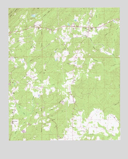
Westover, AL USGS Topographic Map
Click on map above to begin viewing in our Map Viewer.

This topographic map contains these locations and features:
Feature Name Type Latitude Longitude GNIS ID View Map
Caldwell LakeReservoirN33.2587°W86.6083°131359View Map
Caldwell Lake DamDamN33.2584°W86.6100°131360View Map
Camp KanawahalaLocaleN33.3743°W86.5992°146374View Map
Chelsea ChurchChurchN33.3437°W86.6214°146391View Map
Chelsea Fire and Rescue Station 3BuildingN33.3443°W86.5620°2683416View Map
Church of ProphecyChurchN33.2684°W86.5764°1805568View Map
Clear ProngStreamN33.3298°W86.5069°116238View Map
Days CrossroadsLocaleN33.3571°W86.5514°146407View Map
Florence Baptist ChurchChurchN33.2687°W86.5764°118445View Map
Florence CemeteryCemeteryN33.2682°W86.5761°149331View Map
Fourmile Baptist ChurchChurchN33.2579°W86.5403°118549View Map
Fourmile CemeteryCemeteryN33.2582°W86.5389°146434View Map
Fourmile School (historical)SchoolN33.2593°W86.5391°146435View Map
Girl Scout Lake DamDamN33.3734°W86.6050°131494View Map
Hargis Christian RetreatLocaleN33.3654°W86.6000°146451View Map
Hargis LakeReservoirN33.3675°W86.5960°146452View Map
Hargis Memorial ChapelChurchN33.3679°W86.6000°1805575View Map
Hubbard CemeteryCemeteryN33.2787°W86.6186°120492View Map
Indian Hills Country ClubLocaleN33.3279°W86.6217°146468View Map
Kirkland CemeteryCemeteryN33.3029°W86.5139°149338View Map
Lake Hargis DamDamN33.3668°W86.5950°131482View Map
Lesters ChapelChurchN33.2946°W86.6214°152023View Map
Lewis (historical)LocaleN33.2701°W86.5444°146493View Map
Liberty ChurchChurchN33.3307°W86.6222°146494View Map
Little CreekStreamN33.3193°W86.6022°121769View Map
Living Waters Ministries ChurchChurchN33.3543°W86.5205°1805582View Map
Mount Signal CemeteryCemeteryN33.3582°W86.5880°123382View Map
Mount Signal ChurchChurchN33.3559°W86.5897°123383View Map
Mount Tabor ChurchChurchN33.3559°W86.5369°123403View Map
Mount Zion ChurchChurchN33.3562°W86.5325°123480View Map
Nelson Mill (historical)LocaleN33.2737°W86.5908°146533View Map
New Bethesby ChurchChurchN33.2665°W86.6211°152610View Map
New Life Assembly ChurchChurchN33.3504°W86.5450°1805586View Map
North Fork Yellowleaf CreekStreamN33.2987°W86.5819°124004View Map
Oasis Faith Chapel ChurchChurchN33.3204°W86.6183°146627View Map
Page Spring BranchStreamN33.2990°W86.5647°124375View Map
Poplar Spring BranchStreamN33.3526°W86.5028°125161View Map
Prospect Baptist ChurchChurchN33.3215°W86.5561°125305View Map
Prospect CemeteryCemeteryN33.3215°W86.5569°149349View Map
Purdy LakeReservoirN33.3037°W86.6240°131417View Map
Purdy Lake DamDamN33.3034°W86.6217°131418View Map
Quinn CemeteryCemeteryN33.3282°W86.6189°125384View Map
Ray CemeteryCemeteryN33.2912°W86.5525°125456View Map
Roper CemeteryCemeteryN33.2776°W86.5664°125927View Map
Shelby County Landfill Number 2LocaleN33.3487°W86.5180°1805594View Map
South Fork Yellowleaf CreekStreamN33.2982°W86.5819°127122View Map
Spring BranchStreamN33.3073°W86.5903°127215View Map
Teague BridgeBridgeN33.3062°W86.5514°146589View Map
Tinney Mill (historical)LocaleN33.3687°W86.5311°146594View Map
Town of WestoverCivilN33.3716°W86.5357°2406871View Map
Union CemeteryCemeteryN33.3359°W86.5600°146597View Map
Union Methodist ChurchChurchN33.3359°W86.5603°153768View Map
Walton CemeteryCemeteryN33.3137°W86.5864°128569View Map
Weaver CreekStreamN33.2732°W86.6030°128670View Map
Weldon (historical)LocaleN33.3326°W86.5733°146612View Map
WestoverPopulated PlaceN33.3496°W86.5358°157244View Map
Westover ChurchChurchN33.3529°W86.5561°146614View Map
Westover Fire and Rescue DepartmentBuildingN33.3571°W86.5537°2683309View Map
Westover JunctionLocaleN33.3565°W86.5344°146615View Map
Westover Post OfficePost OfficeN33.3533°W86.5357°168824View Map
Westover Volunteer Fire DepartmentBuildingN33.3570°W86.5280°2683249View Map
Wilsonville DivisionCivilN33.2538°W86.5118°165953View Map
Yellowleaf Creek EstatesPopulated PlaceN33.3112°W86.5875°149359View Map

Note: Coordinates in the location and feature list above are referenced to NAD83 datum.


Copyright (C) 2008-2024 Ryan Niemi / Sunset Dynamics ... All Rights Reserved