TopoQuest Logo
Do you find TopoQuest useful?
Help keep TopoQuest running and adding new maps/features by donating!
Bitcoin:  19c7KJd3qBynnjoSw5npx9KScwjBe4ifkT
Litecoin:  LXs6TkuXGGXo1vDsWCkWVdjQX94eUKd6ui
Home View Maps Find Maps Find Places Resources & Links


Belle d'Eau, Louisiana Topographic Map

USGS Map Title: Belle d'Eau, LA
USGS Map MRC: 31092A2
DRG (GeoTIFF) Download: o31092a2.tif


Neighboring USGS Topographic Map Quads:


  Latanier, LA  
31092B3
 

  Effie, LA  
31092B2
 

  Marksville North, LA  
31092B1
 

  Cheneyville, LA  
31092A3
 

  Belle d'Eau, LA  
31092A2
 

  Marksville South, LA  
31092A1
 

  Lone Pine, LA  
30092H3
 

  Bunkie, LA  
30092H2
 

  Cottonport, LA  
30092H1


Map MRC Location:

N32°
W93°
N32°
W92°
H8 H7 H6 H5 H4 H3 H2 H1
G8 G7 G6 G5 G4 G3 G2 G1
F8 F7 F6 F5 F4 F3 F2 F1
E8 E7 E6 E5 E4 E3 E2 E1
D8 D7 D6 D5 D4 D3 D2 D1
C8 C7 C6 C5 C4 C3 C2 C1
B8 B7 B6 B5 B4 B3 B2 B1
A8 A7 A6 A5 A4 A3 A2 A1
N31°
W93°
N31°
W92°

Belle d'Eau, LA USGS 1:24K Topographic Map Preview:
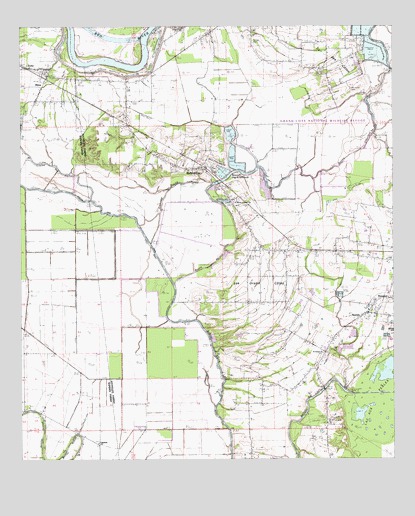
Belle d'Eau, LA USGS Topographic Map
Click on map above to begin viewing in our Map Viewer.

This topographic map contains these locations and features:
Feature Name Type Latitude Longitude GNIS ID View Map
Bayou ChoctawStreamN31.0802°W92.1635°553980View Map
Bayou des AllemandsLakeN31.0821°W92.1823°556239View Map
Belle d'EauPopulated PlaceN31.0844°W92.1918°542977View Map
Belle D'Eau AirstripAirportN31.0849°W92.1829°545485View Map
BijouPopulated PlaceN31.1080°W92.2426°542992View Map
Coulée du PêcheurStreamN31.0752°W92.2085°554100View Map
Detel AirportAirportN31.0477°W92.1322°2770261View Map
EchoPopulated PlaceN31.1102°W92.2418°534761View Map
Echo LandingLocaleN31.1149°W92.2321°551833View Map
Echo Post OfficePost OfficeN31.1120°W92.2428°1631725View Map
Edgefield ChurchChurchN31.0049°W92.2243°534763View Map
Fifth Ward Census Designated PlaceCensusN31.1207°W92.1584°2586678View Map
Grand Cote National Wildlife RefugeParkN31.0979°W92.1385°2765315View Map
Île des CôtesAreaN31.1146°W92.1490°535960View Map
Kalone CemeteryCemeteryN31.1207°W92.1726°536145View Map
Les Grandes CôtesSummitN31.0502°W92.1668°554573View Map
Louisiana Noname 54 DamDamN31.0869°W92.1901°556897View Map
Louisiana School for the Agricultural SciencesSchoolN31.0069°W92.1468°2462937View Map
NormaPopulated PlaceN31.0421°W92.1337°537700View Map
OklahomaPopulated PlaceN31.0088°W92.2085°545560View Map
Old Island CemeteryCemeteryN31.1068°W92.1401°537833View Map
Parish Governing Authority District 12 (historical)CivilN31.0110°W92.1471°1929819View Map
Parish Governing Authority District 2CivilN31.1107°W92.1444°1929877View Map
Saint Daniel ChurchChurchN31.0307°W92.1482°538829View Map
Saint Martin of Tours ChurchChurchN31.0749°W92.1790°541936View Map
Ward FiveCivilN31.1171°W92.1718°544914View Map
Ward FourCivilN31.0544°W92.1282°544913View Map

Note: Coordinates in the location and feature list above are referenced to NAD83 datum.


Copyright (C) 2008-2024 Ryan Niemi / Sunset Dynamics ... All Rights Reserved