TopoQuest Logo
Do you find TopoQuest useful?
Help keep TopoQuest running and adding new maps/features by donating!
Bitcoin:  19c7KJd3qBynnjoSw5npx9KScwjBe4ifkT
Litecoin:  LXs6TkuXGGXo1vDsWCkWVdjQX94eUKd6ui
Home View Maps Find Maps Find Places Resources & Links


Cherokee, Kansas Topographic Map

USGS Map Title: Cherokee, KS
USGS Map MRC: 37094C7
DRG (GeoTIFF) Download: o37094c7.tif


Neighboring USGS Topographic Map Quads:


  Grindstone Creek, KS  
37094D8
 

  Radley, KS  
37094D7
 

  Pittsburg, KS  
37094D6
 

  West Mineral, KS  
37094C8
 

  Cherokee, KS  
37094C7
 

  Kirkwood, KS  
37094C6
 

  Hallowell, KS  
37094B8
 

  Columbus, KS  
37094B7
 

  Crestline, KS  
37094B6


Map MRC Location:

N38°
W95°
N38°
W94°
H8 H7 H6 H5 H4 H3 H2 H1
G8 G7 G6 G5 G4 G3 G2 G1
F8 F7 F6 F5 F4 F3 F2 F1
E8 E7 E6 E5 E4 E3 E2 E1
D8 D7 D6 D5 D4 D3 D2 D1
C8 C7 C6 C5 C4 C3 C2 C1
B8 B7 B6 B5 B4 B3 B2 B1
A8 A7 A6 A5 A4 A3 A2 A1
N37°
W95°
N37°
W94°

Cherokee, KS USGS 1:24K Topographic Map Preview:
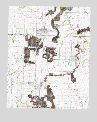
Cherokee, KS USGS Topographic Map
Click on map above to begin viewing in our Map Viewer.

This topographic map contains these locations and features:
Feature Name Type Latitude Longitude GNIS ID View Map
Barrett (historical)Populated PlaceN37.3334°W94.7780°483286View Map
CaronaPopulated PlaceN37.2803°W94.8686°482751View Map
CherokeePopulated PlaceN37.3459°W94.8089°469610View Map
Cherokee CemeteryCemeteryN37.3604°W94.8296°469609View Map
Cherokee City Fire DepartmentBuildingN37.3430°W94.8206°2111189View Map
Cherokee City HallBuildingN37.3442°W94.8205°2693323View Map
Cherokee Elementary SchoolSchoolN37.3459°W94.8223°481103View Map
Cherokee Police DepartmentBuildingN37.3430°W94.8206°2503964View Map
Cherokee TankReservoirN37.3214°W94.8208°469619View Map
Cherokee Township Volunteer Fire DepartmentBuildingN37.3103°W94.7695°2111190View Map
Cherokee United Methodist ChurchChurchN37.3457°W94.8245°2689373View Map
Cherokee Wastewater PlantLocaleN37.3413°W94.8434°2691936View Map
City of CherokeeCivilN37.3451°W94.8216°2393818View Map
City of RoselandCivilN37.2803°W94.8441°2396432View Map
City of ScammonCivilN37.2782°W94.8229°485650View Map
City of WeirCivilN37.3083°W94.7745°485657View Map
Coal Valley (historical)Populated PlaceN37.3245°W94.7794°483287View Map
Community of ChristChurchN37.2769°W94.8201°2689765View Map
Countryside Golf CourseLocaleN37.3605°W94.7716°2694489View Map
Daisy HillPopulated PlaceN37.3278°W94.7780°484469View Map
Dutch Hollow (historical)Populated PlaceN37.3162°W94.7794°483288View Map
Faith Christian AcademySchoolN37.3116°W94.7759°2437474View Map
Faith Tabernacle Assembly of God ChurchChurchN37.3116°W94.7758°2688928View Map
First Baptist ChurchChurchN37.3107°W94.7703°2688976View Map
First Baptist Church of CherokeeChurchN37.3437°W94.8206°2689693View Map
FlemingPopulated PlaceN37.3681°W94.7830°484467View Map
Hosey Hill CemeteryCemeteryN37.3129°W94.8096°1926205View Map
Humble School (historical)SchoolN37.3106°W94.8316°483335View Map
KKOW - FM (Pittsburg)BuildingN37.3126°W94.8162°2625230View Map
KlendikePopulated PlaceN37.3678°W94.7597°484468View Map
KRPS - FM (Pittsburg)BuildingN37.3126°W94.8162°2625303View Map
MackiePopulated PlaceN37.2520°W94.8502°484470View Map
Maplewood School (historical)SchoolN37.3253°W94.8683°483341View Map
Murphy School (historical)SchoolN37.2814°W94.7966°483353View Map
RoselandPopulated PlaceN37.2812°W94.8505°469613View Map
Saint Anthony CemeteryCemeteryN37.3019°W94.7592°469611View Map
Saint Bridget Catholic ChurchChurchN37.2786°W94.8207°2689745View Map
Saint Bridget CemeteryCemeteryN37.2806°W94.8065°469614View Map
ScammonPopulated PlaceN37.2776°W94.8250°469615View Map
Scammon City HallBuildingN37.2777°W94.8227°2693380View Map
Scammon Elementary SchoolSchoolN37.2809°W94.8196°481102View Map
Scammon Presbyterian ChurchChurchN37.2778°W94.8174°2690594View Map
Scammon Volunteer Fire DepartmentBuildingN37.2773°W94.8152°2111842View Map
Scammon Wastewater Treatment FacilityLocaleN37.2772°W94.8283°2691938View Map
Skidmore School (historical)SchoolN37.2517°W94.8316°483366View Map
Southeast High SchoolSchoolN37.3408°W94.8367°469608View Map
Stilson (historical)LocaleN37.2662°W94.8238°482076View Map
Township of CherokeeCivilN37.3009°W94.7603°469617View Map
Township of MineralCivilN37.2521°W94.7895°469331View Map
WeirPopulated PlaceN37.3101°W94.7719°469612View Map
Weir City Volunteer Fire DepartmentBuildingN37.3125°W94.7715°2111972View Map
Weir Elementary SchoolSchoolN37.3077°W94.7839°2437473View Map
Weir Police DepartmentBuildingN37.3052°W94.7703°2503922View Map
Weir Post OfficePost OfficeN37.3102°W94.7706°2694015View Map
Weir Public LibraryBuildingN37.3052°W94.7703°2694888View Map
Weir United Methodist ChurchChurchN37.3069°W94.7705°2689250View Map
Weir Wastewater Treatment PlantLocaleN37.3158°W94.7657°2692011View Map

Note: Coordinates in the location and feature list above are referenced to NAD83 datum.


Copyright (C) 2008-2025 Ryan Niemi / Sunset Dynamics ... All Rights Reserved