TopoQuest Logo
Do you find TopoQuest useful?
Help keep TopoQuest running and adding new maps/features by donating!
Bitcoin:  19c7KJd3qBynnjoSw5npx9KScwjBe4ifkT
Litecoin:  LXs6TkuXGGXo1vDsWCkWVdjQX94eUKd6ui
Home View Maps Find Maps Find Places Resources & Links


Hallowell, Kansas Topographic Map

USGS Map Title: Hallowell, KS
USGS Map MRC: 37094B8
DRG (GeoTIFF) Download: o37094b8.tif


Neighboring USGS Topographic Map Quads:


  McCune, KS  
37095C1
 

  West Mineral, KS  
37094C8
 

  Cherokee, KS  
37094C7
 

  Oswego, KS  
37095B1
 

  Hallowell, KS  
37094B8
 

  Columbus, KS  
37094B7
 

  Chetopa, KS  
37095A1
 

  Melrose, KS  
37094A8
 

  Neutral, KS  
37094A7


Map MRC Location:

N38°
W95°
N38°
W94°
H8 H7 H6 H5 H4 H3 H2 H1
G8 G7 G6 G5 G4 G3 G2 G1
F8 F7 F6 F5 F4 F3 F2 F1
E8 E7 E6 E5 E4 E3 E2 E1
D8 D7 D6 D5 D4 D3 D2 D1
C8 C7 C6 C5 C4 C3 C2 C1
B8 B7 B6 B5 B4 B3 B2 B1
A8 A7 A6 A5 A4 A3 A2 A1
N37°
W95°
N37°
W94°

Hallowell, KS USGS 1:24K Topographic Map Preview:
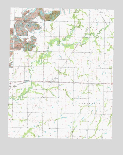
Hallowell, KS USGS Topographic Map
Click on map above to begin viewing in our Map Viewer.

This topographic map contains these locations and features:
Feature Name Type Latitude Longitude GNIS ID View Map
Cherokee PlainsPlainN37.1667°W94.9336°480163View Map
CokedalePopulated PlaceN37.2467°W94.8927°484448View Map
Cross Roads School (historical)SchoolN37.2087°W94.9958°483323View Map
Denny BranchStreamN37.1762°W94.9730°469473View Map
Dove CemeteryCemeteryN37.1640°W94.9827°469474View Map
Edgmand CemeteryCemeteryN37.2088°W94.8878°469475View Map
Fleming (historical)LocaleN37.2317°W94.8811°483327View Map
Geni School (historical)SchoolN37.1270°W94.9136°483331View Map
Globe School (historical)SchoolN37.1345°W94.9950°483332View Map
HallowellPopulated PlaceN37.1748°W94.9955°469477View Map
Jenesse School (historical)SchoolN37.1495°W94.9041°483339View Map
LaRue CemeteryCemeteryN37.2189°W94.9411°2056984View Map
Little Cherry CreekStreamN37.2184°W94.9427°469493View Map
Milam School (historical)SchoolN37.1645°W94.9588°483343View Map
Millersburg School (historical)SchoolN37.2231°W94.9133°483344View Map
Mormon School (historical)SchoolN37.1781°W94.8950°483346View Map
New Winsor (historical)LocaleN37.1348°W94.9308°482077View Map
Richland Valley School (historical)SchoolN37.2012°W94.9408°483362View Map
Rising Sun School (historical)SchoolN37.2373°W94.9772°483363View Map
SherwinPopulated PlaceN37.1801°W94.9477°484447View Map
Sherwin Christian ChurchChurchN37.1805°W94.9437°2689205View Map
Spickelmire CemeteryCemeteryN37.1734°W94.9716°2057005View Map
Strip Pits State Wildlife Management AreaParkN37.2389°W94.9725°469478View Map
Township of SalamancaCivilN37.1633°W94.8888°469271View Map

Note: Coordinates in the location and feature list above are referenced to NAD83 datum.


Copyright (C) 2008-2024 Ryan Niemi / Sunset Dynamics ... All Rights Reserved