TopoQuest Logo
Do you find TopoQuest useful?
Help keep TopoQuest running and adding new maps/features by donating!
Bitcoin:  19c7KJd3qBynnjoSw5npx9KScwjBe4ifkT
Litecoin:  LXs6TkuXGGXo1vDsWCkWVdjQX94eUKd6ui
Home View Maps Find Maps Find Places Resources & Links


Chickalah Mountain East, Arkansas Topographic Map

USGS Map Title: Chickalah Mountain East, AR
USGS Map MRC: 35093B3
DRG (GeoTIFF) Download: o35093b3.tif


Neighboring USGS Topographic Map Quads:


  New Blaine, AR  
35093C4
 

  Delaware, AR  
35093C3
 

  Russellville West, AR  
35093C2
 

  Chickalah Mountain West, AR  
35093B4
 

  Chickalah Mountain East, AR  
35093B3
 

  Dardanelle, AR  
35093B2
 

  Danville, AR  
35093A4
 

  Danville Mountain, AR  
35093A3
 

  Ola, AR  
35093A2


Map MRC Location:

N36°
W94°
N36°
W93°
H8 H7 H6 H5 H4 H3 H2 H1
G8 G7 G6 G5 G4 G3 G2 G1
F8 F7 F6 F5 F4 F3 F2 F1
E8 E7 E6 E5 E4 E3 E2 E1
D8 D7 D6 D5 D4 D3 D2 D1
C8 C7 C6 C5 C4 C3 C2 C1
B8 B7 B6 B5 B4 B3 B2 B1
A8 A7 A6 A5 A4 A3 A2 A1
N35°
W94°
N35°
W93°

Chickalah Mountain East, AR USGS 1:24K Topographic Map Preview:
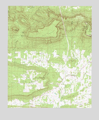
Chickalah Mountain East, AR USGS Topographic Map
Click on map above to begin viewing in our Map Viewer.

This topographic map contains these locations and features:
Feature Name Type Latitude Longitude GNIS ID View Map
Bear MountainSummitN35.2293°W93.3474°70570View Map
Bogs LakeReservoirN35.1335°W93.2963°74693View Map
Carter BranchStreamN35.1673°W93.2985°67864View Map
ChickalahPopulated PlaceN35.1643°W93.2785°71130View Map
Chickalah Methodist CemeteryCemeteryN35.1679°W93.2866°2029240View Map
Chickalah Mountain ChurchChurchN35.1559°W93.3380°71133View Map
Chickalah Rural Fire Department Station 1BuildingN35.1639°W93.2790°2116267View Map
Chickalah Rural Fire Department Station 2BuildingN35.1552°W93.3387°2116268View Map
Christian RidgeRidgeN35.1387°W93.2802°71148View Map
Darling SpringSpringN35.2220°W93.2591°71338View Map
Dean Reid KnobSummitN35.2204°W93.3635°48432View Map
Fullton CemeteryCemeteryN35.1648°W93.2852°2026162View Map
Gately School (historical)SchoolN35.1887°W93.3691°67891View Map
Gobblers KnobSummitN35.2176°W93.3507°71775View Map
Gwin RiverStreamN35.1406°W93.2924°77098View Map
Haags HollowValleyN35.1723°W93.3127°71869View Map
Hale CemeteryCemeteryN35.1276°W93.2643°77104View Map
Harkey ValleyValleyN35.1773°W93.3149°71906View Map
John Harris FieldAirportN35.2153°W93.3059°2650785View Map
Jordan BranchStreamN35.1818°W93.3688°72221View Map
KWKK-FM (Dardanelle)TowerN35.2281°W93.2557°85380View Map
Little Chickalah CreekStreamN35.1551°W93.2921°72380View Map
Macedonia Church (historical)ChurchN35.2476°W93.2755°67907View Map
Magnolia School (historical)SchoolN35.1326°W93.3107°67909View Map
Mc Cray RidgeRidgeN35.1829°W93.2791°72577View Map
Moore MountainSummitN35.2334°W93.3682°72724View Map
MosleyPopulated PlaceN35.1812°W93.2518°72739View Map
Mount NeboPopulated PlaceN35.2190°W93.2524°67916View Map
Mount NeboSummitN35.2168°W93.2518°72838View Map
Mount Nebo Post Office (historical)Post OfficeN35.2190°W93.2524°2026804View Map
Mount Nebo State ParkParkN35.2209°W93.2549°72758View Map
Mount Nebo Volunteer Fire DepartmentBuildingN35.2192°W93.2528°2116821View Map
Mountain Spring CemeteryCemeteryN35.1615°W93.3480°72791View Map
Mountain Springs School (historical)SchoolN35.1573°W93.3474°67923View Map
Omega School (historical)SchoolN35.1315°W93.2555°67932View Map
Robinson Point ChurchChurchN35.1854°W93.2727°73323View Map
Rock CreekStreamN35.1756°W93.3107°67943View Map
Sheppard CemeteryCemeteryN35.1287°W93.2646°73534View Map
Shiloah Church (historical)ChurchN35.1865°W93.2855°67949View Map
Shiloh School (historical)SchoolN35.1865°W93.2855°67950View Map
Spring MountainSummitN35.2148°W93.3157°73676View Map
Sulphur SpringsPopulated PlaceN35.1926°W93.3260°73777View Map
Sunrise PointCapeN35.2126°W93.2505°73784View Map
Sunset PointCapeN35.2304°W93.2599°73785View Map
Tater HillSummitN35.2290°W93.2835°73829View Map
Township of MagazineCivilN35.1447°W93.2625°69883View Map
Township of Sulphur SpringsCivilN35.1957°W93.3696°69891View Map

Note: Coordinates in the location and feature list above are referenced to NAD83 datum.


Copyright (C) 2008-2025 Ryan Niemi / Sunset Dynamics ... All Rights Reserved