TopoQuest Logo
Do you find TopoQuest useful?
Help keep TopoQuest running and adding new maps/features by donating!
Bitcoin:  19c7KJd3qBynnjoSw5npx9KScwjBe4ifkT
Litecoin:  LXs6TkuXGGXo1vDsWCkWVdjQX94eUKd6ui
Home View Maps Find Maps Find Places Resources & Links


New Blaine, Arkansas Topographic Map

USGS Map Title: New Blaine, AR
USGS Map MRC: 35093C4
DRG (GeoTIFF) Download: o35093c4.tif


Neighboring USGS Topographic Map Quads:


  Hartman, AR  
35093D5
 

  Clarksville, AR  
35093D4
 

  Knoxville, AR  
35093D3
 

  Scranton, AR  
35093C5
 

  New Blaine, AR  
35093C4
 

  Delaware, AR  
35093C3
 

  Magazine Mountain NE, AR  
35093B5
 

  Chickalah Mountain West, AR  
35093B4
 

  Chickalah Mountain East, AR  
35093B3


Map MRC Location:

N36°
W94°
N36°
W93°
H8 H7 H6 H5 H4 H3 H2 H1
G8 G7 G6 G5 G4 G3 G2 G1
F8 F7 F6 F5 F4 F3 F2 F1
E8 E7 E6 E5 E4 E3 E2 E1
D8 D7 D6 D5 D4 D3 D2 D1
C8 C7 C6 C5 C4 C3 C2 C1
B8 B7 B6 B5 B4 B3 B2 B1
A8 A7 A6 A5 A4 A3 A2 A1
N35°
W94°
N35°
W93°

New Blaine, AR USGS 1:24K Topographic Map Preview:
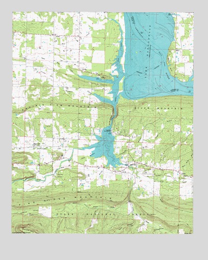
New Blaine, AR USGS Topographic Map
Click on map above to begin viewing in our Map Viewer.

This topographic map contains these locations and features:
Feature Name Type Latitude Longitude GNIS ID View Map
BendPopulated PlaceN35.3543°W93.3874°70626View Map
Big Shoal CreekStreamN35.3287°W93.3863°70392View Map
Brock CreekStreamN35.2801°W93.3988°70826View Map
Burton BluffCliffN35.3476°W93.3930°70937View Map
Buzzards RockCapeN35.2515°W93.4888°70946View Map
Cabin CreekStreamN35.3576°W93.3910°70949View Map
Cedar BottomFlatN35.2937°W93.4480°71051View Map
Church of ChristChurchN35.2856°W93.4291°79226View Map
Collins ShoalsBarN35.3490°W93.3960°71203View Map
Copper BranchStreamN35.3031°W93.4116°71229View Map
DublinPopulated PlaceN35.3620°W93.4713°71463View Map
Dublin ParkParkN35.3395°W93.4435°64191View Map
Egypt HollowValleyN35.2581°W93.4152°71542View Map
Freewill Baptist ChurchChurchN35.3595°W93.4710°79221View Map
Freewill Baptist ChurchChurchN35.3426°W93.4541°79222View Map
Frietsche CemeteryCemeteryN35.3004°W93.4466°71696View Map
Geren (historical)Populated PlaceN35.3745°W93.4246°64192View Map
Hall CemeteryCemeteryN35.2842°W93.4088°71877View Map
JohnsonPopulated PlaceN35.3429°W93.4538°72200View Map
Lake DardanelleReservoirN35.3540°W93.3961°74782View Map
Little Bigger CreekStreamN35.2684°W93.4196°72368View Map
Little Shoal CreekStreamN35.3040°W93.4355°72422View Map
May CemeteryCemeteryN35.2823°W93.4691°72574View Map
McReynolds CemeteryCemeteryN35.2515°W93.4016°72618View Map
Mill CreekStreamN35.2868°W93.4157°72663View Map
Mud CreekStreamN35.3398°W93.4230°72802View Map
New BlainePopulated PlaceN35.2895°W93.4202°77809View Map
New Blaine Census Designated PlaceCensusN35.2929°W93.4203°2612130View Map
New Blaine Community ParkParkN35.2881°W93.4230°79225View Map
New Blaine Post OfficePost OfficeN35.2902°W93.4154°84257View Map
New Blaine Rural Fire Department Shoal Creek StationBuildingN35.3029°W93.4647°2116844View Map
New Blaine Rural Fire Department Station 1BuildingN35.2868°W93.4234°2116845View Map
New Blaine SchoolSchoolN35.2851°W93.4219°79148View Map
Pee Dee CreekStreamN35.2979°W93.4574°73035View Map
Pigeon Roost CreekStreamN35.3362°W93.4280°73072View Map
Pioneer Memorial Methodist ChurchChurchN35.2995°W93.4813°79223View Map
Prairie BranchStreamN35.2918°W93.4307°73188View Map
Saint ScholasticaPopulated PlaceN35.3037°W93.4641°64189View Map
Saint Scholastica Catholic ChurchChurchN35.3034°W93.4638°79229View Map
Saint Scholastica CemeteryCemeteryN35.3029°W93.4641°79228View Map
Saint Scholastica SchoolSchoolN35.3031°W93.4641°79156View Map
Scranton Fire Department Station 2BuildingN35.3616°W93.4716°2117101View Map
Shoal Bay Recreation AreaParkN35.3101°W93.4307°79176View Map
Shoal CreekPopulated PlaceN35.3006°W93.4852°78355View Map
Shoal Creek IslandIslandN35.3329°W93.3935°79158View Map
Shoal Creek Methodist Youth CampLocaleN35.2840°W93.4688°79224View Map
Shoal Creek NarrowsChannelN35.3168°W93.4288°73555View Map
Shoal Creek NarrowsGutN35.3159°W93.4299°79227View Map
Silversmith BranchStreamN35.2929°W93.4310°73582View Map
Sommer (historical)Populated PlaceN35.3245°W93.4380°64190View Map
Tater HillSummitN35.2937°W93.4677°73830View Map
Thompson BranchStreamN35.3226°W93.4294°73855View Map
Township of Cane CreekCivilN35.3567°W93.4493°68790View Map
Township of HowellCivilN35.3656°W93.3759°66757View Map
Township of Shoal CreekCivilN35.2707°W93.4331°68803View Map
Tritt CemeteryCemeteryN35.2737°W93.4546°73895View Map
West Fork Mill CreekStreamN35.2795°W93.3849°74064View Map

Note: Coordinates in the location and feature list above are referenced to NAD83 datum.


Copyright (C) 2008-2024 Ryan Niemi / Sunset Dynamics ... All Rights Reserved