TopoQuest Logo
Do you find TopoQuest useful?
Help keep TopoQuest running and adding new maps/features by donating!
Bitcoin:  19c7KJd3qBynnjoSw5npx9KScwjBe4ifkT
Litecoin:  LXs6TkuXGGXo1vDsWCkWVdjQX94eUKd6ui
Home View Maps Find Maps Find Places Resources & Links


Delaware, Arkansas Topographic Map

USGS Map Title: Delaware, AR
USGS Map MRC: 35093C3
DRG (GeoTIFF) Download: o35093c3.tif


Neighboring USGS Topographic Map Quads:


  Clarksville, AR  
35093D4
 

  Knoxville, AR  
35093D3
 

  Lee Mountain, AR  
35093D2
 

  New Blaine, AR  
35093C4
 

  Delaware, AR  
35093C3
 

  Russellville West, AR  
35093C2
 

  Chickalah Mountain West, AR  
35093B4
 

  Chickalah Mountain East, AR  
35093B3
 

  Dardanelle, AR  
35093B2


Map MRC Location:

N36°
W94°
N36°
W93°
H8 H7 H6 H5 H4 H3 H2 H1
G8 G7 G6 G5 G4 G3 G2 G1
F8 F7 F6 F5 F4 F3 F2 F1
E8 E7 E6 E5 E4 E3 E2 E1
D8 D7 D6 D5 D4 D3 D2 D1
C8 C7 C6 C5 C4 C3 C2 C1
B8 B7 B6 B5 B4 B3 B2 B1
A8 A7 A6 A5 A4 A3 A2 A1
N35°
W94°
N35°
W93°

Delaware, AR USGS 1:24K Topographic Map Preview:
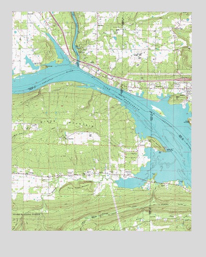
Delaware, AR USGS Topographic Map
Click on map above to begin viewing in our Map Viewer.

This topographic map contains these locations and features:
Feature Name Type Latitude Longitude GNIS ID View Map
Big Piney CreekStreamN35.3429°W93.3288°76343View Map
Bluebaugh HillSummitN35.3437°W93.3524°70739View Map
Brock CemeteryCemeteryN35.3384°W93.3110°70825View Map
Bullock CemeteryCemeteryN35.2784°W93.2560°70923View Map
Cave BranchStreamN35.2915°W93.2766°71040View Map
Charlie Rollans MountainSummitN35.2773°W93.3205°71117View Map
Chastain CemeteryCemeteryN35.2829°W93.2952°71118View Map
Clubb HillSummitN35.3551°W93.3496°71175View Map
DelawarePopulated PlaceN35.2837°W93.2988°71363View Map
Delaware CreekStreamN35.2887°W93.2699°71364View Map
Delaware ParkParkN35.2912°W93.2663°67883View Map
Delaware Post OfficePost OfficeN35.2831°W93.2972°84256View Map
Delaware Volunteer Fire DepartmentBuildingN35.2844°W93.2982°2116353View Map
Dry ForkStreamN35.2579°W93.3238°71453View Map
Durvin CemeteryCemeteryN35.2826°W93.2752°71477View Map
First Baptist ChurchChurchN35.2829°W93.3252°79181View Map
Flat RockLocaleN35.3673°W93.3160°71624View Map
Flat Rock Assembly of God ChurchChurchN35.3626°W93.3166°65145View Map
Flat Rock CreekStreamN35.3554°W93.3318°71625View Map
Flat Rock Use AreaParkN35.3526°W93.3280°65146View Map
Garrison CemeteryCemeteryN35.2834°W93.3241°79180View Map
GeorgetownPopulated PlaceN35.3334°W93.2760°77007View Map
Georgetown Church of ChristChurchN35.3343°W93.2771°62064View Map
Georgetown School (historical)SchoolN35.3343°W93.2771°62065View Map
Goose IslandIslandN35.3001°W93.2616°71789View Map
Graves CemeteryCemeteryN35.2829°W93.3232°71820View Map
Hon CemeteryCemeteryN35.3729°W93.3288°72056View Map
Interchange 74CrossingN35.3365°W93.2568°58990View Map
Johnson CemeteryCemeteryN35.2840°W93.3046°72204View Map
Johnson County Rural Fire District 5 Flat RockBuildingN35.3574°W93.3158°2116645View Map
Lake Dardanelle State Fish HatcheryLocaleN35.3423°W93.3574°79182View Map
Lake VinsonReservoirN35.3724°W93.2774°79721View Map
Lake Vinson DamDamN35.3718°W93.2768°79720View Map
LibertyPopulated PlaceN35.2820°W93.3624°72318View Map
Little MountainSummitN35.3023°W93.2785°72408View Map
LondonPopulated PlaceN35.3290°W93.2530°77539View Map
London MountainSummitN35.3620°W93.2613°72451View Map
London Police DepartmentBuildingN35.3306°W93.2540°2118873View Map
London Rural Fire StationBuildingN35.3312°W93.2567°2116736View Map
Martin Chapel Assembly of God ChurchChurchN35.3656°W93.2627°77602View Map
Martins School (historical)SchoolN35.3698°W93.2710°62069View Map
Mount Nebo Oil and Gas FieldOilfieldN35.2534°W93.2780°82599View Map
Negro HillSummitN35.3270°W93.2618°72843View Map
New Liberty ChurchChurchN35.2834°W93.3718°79179View Map
PineyPopulated PlaceN35.3445°W93.3255°73102View Map
Piney Bible Baptist ChurchChurchN35.3434°W93.3216°65169View Map
Pledger CemeteryCemeteryN35.3012°W93.2804°73140View Map
Price CemeteryCemeteryN35.3317°W93.2699°73199View Map
River MountainLocaleN35.3031°W93.3393°73307View Map
River MountainSummitN35.3109°W93.3355°73308View Map
RiversidePopulated PlaceN35.2990°W93.2868°73309View Map
Rocky BranchStreamN35.2793°W93.3307°64193View Map
ScotiaPopulated PlaceN35.3312°W93.2924°73495View Map
Shoptaw CemeteryCemeteryN35.3662°W93.3004°73563View Map
SillsPopulated PlaceN35.2779°W93.2771°73581View Map
Stinnett CemeteryCemeteryN35.2765°W93.2716°73718View Map
Stinnett CreekStreamN35.2884°W93.2705°73719View Map
Township of DelawareCivilN35.2726°W93.3325°68793View Map
Township of Delaware (historical)CivilN35.2668°W93.2516°67885View Map
Utley CemeteryCemeteryN35.3467°W93.3316°73953View Map
Wildcat HollowValleyN35.2590°W93.2746°74147View Map
Woods HollowValleyN35.2637°W93.2846°74208View Map

Note: Coordinates in the location and feature list above are referenced to NAD83 datum.


Copyright (C) 2008-2025 Ryan Niemi / Sunset Dynamics ... All Rights Reserved