TopoQuest Logo
Do you find TopoQuest useful?
Help keep TopoQuest running and adding new maps/features by donating!
Bitcoin:  19c7KJd3qBynnjoSw5npx9KScwjBe4ifkT
Litecoin:  LXs6TkuXGGXo1vDsWCkWVdjQX94eUKd6ui
Home View Maps Find Maps Find Places Resources & Links


Amelia City, Florida Topographic Map

USGS Map Title: Amelia City, FL
USGS Map MRC: 30081E4
DRG (GeoTIFF) Download: o30081e4.tif


Neighboring USGS Topographic Map Quads:


  Saint Marys, GA  
30081F5
 

  Fernandina Beach, FL  
30081F4


  Hedges, FL  
30081E5
 

  Amelia City, FL  
30081E4


  Eastport, FL  
30081D5
 

  Mayport, FL  
30081D4


Map MRC Location:

N31°
W82°
N31°
W81°
H8 H7 H6 H5 H4 H3 H2 H1
G8 G7 G6 G5 G4 G3 G2 G1
F8 F7 F6 F5 F4 F3 F2 F1
E8 E7 E6 E5 E4 E3 E2 E1
D8 D7 D6 D5 D4 D3 D2 D1
C8 C7 C6 C5 C4 C3 C2 C1
B8 B7 B6 B5 B4 B3 B2 B1
A8 A7 A6 A5 A4 A3 A2 A1
N30°
W82°
N30°
W81°

Amelia City, FL USGS 1:24K Topographic Map Preview:
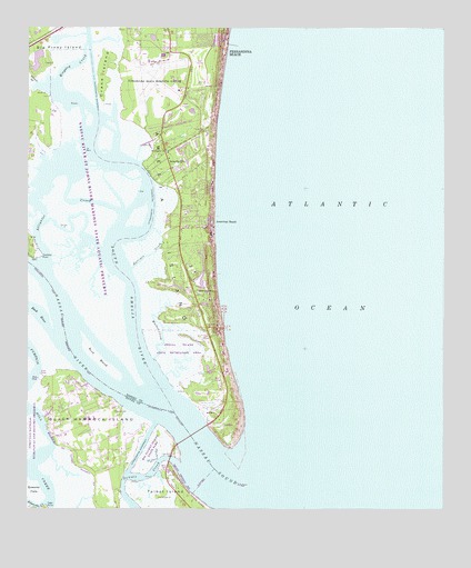
Amelia City, FL USGS Topographic Map
Click on map above to begin viewing in our Map Viewer.

This topographic map contains these locations and features:
Feature Name Type Latitude Longitude GNIS ID View Map
Amelia CityPopulated PlaceN30.5902°W81.4573°294652View Map
Amelia IslandIslandN30.6077°W81.4601°294302View Map
Amelia Island State ParkParkN30.5300°W81.4379°1946050View Map
American BeachPopulated PlaceN30.5750°W81.4440°277835View Map
Back RiverStreamN30.5447°W81.4918°278024View Map
Big Piney IslandIslandN30.6188°W81.4901°278726View Map
Black HammockPopulated PlaceN30.5225°W81.4806°295046View Map
Black Hammock IslandIslandN30.5022°W81.4759°278897View Map
Crane IslandIslandN30.6125°W81.4773°280997View Map
Deland Country ClubLocaleN30.6148°W81.4490°2448885View Map
Delray Beach Golf ClubLocaleN30.5936°W81.4490°2448886View Map
Elwood BranchStreamN30.6105°W81.4976°282188View Map
Fernandina Beach DivisionCivilN30.6142°W81.4207°1935765View Map
Fernandina Beach Municipal AirportAirportN30.6160°W81.4627°309396View Map
FranklintownPopulated PlaceN30.5563°W81.4495°295305View Map
Harrison CreekStreamN30.5625°W81.4681°283770View Map
Jacksonville Fire and Rescue Department Station 45BuildingN30.5212°W81.4803°2644340View Map
Kingsley CreekGutN30.6161°W81.4851°304696View Map
Mary Smith GrantCivilN30.5008°W81.4748°304013View Map
Mesa MarshSwampN30.5379°W81.4773°286739View Map
Nassau County Fire and Rescue Station 20BuildingN30.5724°W81.4538°2643994View Map
Nassau RiverStreamN30.5133°W81.4390°287544View Map
Nassau SoundBayN30.5113°W81.4469°294316View Map
Saint Pauls ChurchChurchN30.5933°W81.4581°290363View Map
Sandpiper Mobile Home ParkPopulated PlaceN30.5831°W81.4541°2448888View Map
Sawpit CreekStreamN30.5116°W81.4543°290729View Map
Seymour PointCapeN30.5655°W81.4956°290888View Map
South Amelia RiverStreamN30.5313°W81.4598°294319View Map
Tiger PointCapeN30.5008°W81.4937°292285View Map
Walker CreekStreamN30.5383°W81.4612°292833View Map

Note: Coordinates in the location and feature list above are referenced to NAD83 datum.


Copyright (C) 2008-2024 Ryan Niemi / Sunset Dynamics ... All Rights Reserved