TopoQuest Logo
Do you find TopoQuest useful?
Help keep TopoQuest running and adding new maps/features by donating!
Bitcoin:  19c7KJd3qBynnjoSw5npx9KScwjBe4ifkT
Litecoin:  LXs6TkuXGGXo1vDsWCkWVdjQX94eUKd6ui
Home View Maps Find Maps Find Places Resources & Links


Hedges, Florida Topographic Map

USGS Map Title: Hedges, FL
USGS Map MRC: 30081E5
DRG (GeoTIFF) Download: o30081e5.tif


Neighboring USGS Topographic Map Quads:


  Gross, FL  
30081F6
 

  Saint Marys, GA  
30081F5
 

  Fernandina Beach, FL  
30081F4
 

  Italia, FL  
30081E6
 

  Hedges, FL  
30081E5
 

  Amelia City, FL  
30081E4
 

  Trout River, FL  
30081D6
 

  Eastport, FL  
30081D5
 

  Mayport, FL  
30081D4


Map MRC Location:

N31°
W82°
N31°
W81°
H8 H7 H6 H5 H4 H3 H2 H1
G8 G7 G6 G5 G4 G3 G2 G1
F8 F7 F6 F5 F4 F3 F2 F1
E8 E7 E6 E5 E4 E3 E2 E1
D8 D7 D6 D5 D4 D3 D2 D1
C8 C7 C6 C5 C4 C3 C2 C1
B8 B7 B6 B5 B4 B3 B2 B1
A8 A7 A6 A5 A4 A3 A2 A1
N30°
W82°
N30°
W81°

Hedges, FL USGS 1:24K Topographic Map Preview:
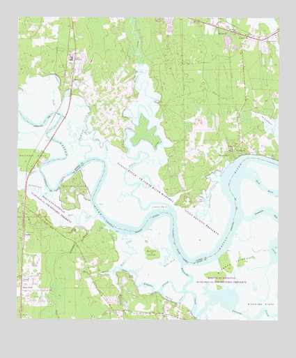
Hedges, FL USGS Topographic Map
Click on map above to begin viewing in our Map Viewer.

This topographic map contains these locations and features:
Feature Name Type Latitude Longitude GNIS ID View Map
Bowles CemeteryCemeteryN30.5361°W81.5973°279293View Map
Broward IslandsIslandN30.5219°W81.5226°279461View Map
Burton CreekStreamN30.5283°W81.5495°279720View Map
Burton IslandIslandN30.5277°W81.5601°279721View Map
Christopher CreekStreamN30.5597°W81.5276°280437View Map
Cuno CreekStreamN30.5661°W81.5832°281157View Map
Cyrus Briggs GrantCivilN30.5572°W81.5987°303984View Map
Deese CreekStreamN30.5433°W81.5859°281468View Map
Edwards CreekChannelN30.5047°W81.5223°282108View Map
Edwards FlatsFlatN30.5069°W81.5068°282109View Map
Ferreira CemeteryCemeteryN30.5016°W81.5529°282435View Map
Flying-A-Ranch AirportAirportN30.6014°W81.5694°309398View Map
Gardner CreekStreamN30.5663°W81.5918°282937View Map
Grandaddy BranchStreamN30.5386°W81.5918°283277View Map
Halfmoon IslandIslandN30.5663°W81.6204°283601View Map
Halfmoon ParkParkN30.5608°W81.6173°304690View Map
Hawks Nest Golf ClubLocaleN30.5241°W81.6183°2449471View Map
HedgesPopulated PlaceN30.5991°W81.5984°283857View Map
Henderson LandingLocaleN30.5100°W81.5579°295344View Map
Homer LandingLocaleN30.5902°W81.5582°295355View Map
Inconstantion CreekStreamN30.5527°W81.6095°284479View Map
J Bachlott GrantCivilN30.5258°W81.5118°303988View Map
Jacksonville Fire and Rescue Department Station 49BuildingN30.5090°W81.5838°2644218View Map
Jerry LandingLocaleN30.6013°W81.5684°295380View Map
John Houston GrantCivilN30.5163°W81.5937°304014View Map
Lofton CreekStreamN30.5458°W81.5506°285917View Map
Lofton PointCapeN30.5463°W81.5531°285919View Map
Lumber CreekStreamN30.5863°W81.6065°286211View Map
Memorial ChurchChurchN30.6194°W81.5201°286700View Map
Mill BranchStreamN30.5205°W81.5787°286856View Map
Mink CreekStreamN30.5352°W81.5720°286959View Map
Moses Harrold GrantCivilN30.5080°W81.5673°303986View Map
Mount Zion ChurchChurchN30.6186°W81.5243°287359View Map
Nassau County Fire and Rescue Station 3ABuildingN30.6053°W81.5712°2644682View Map
Nassau County Fire and Rescue Station 7BuildingN30.5785°W81.5187°2644109View Map
Nassau County Fire and Rescue Station 70BuildingN30.6167°W81.5134°2644268View Map
NassauvillePopulated PlaceN30.5694°W81.5195°295476View Map
O'NeilPopulated PlaceN30.6175°W81.5143°287919View Map
Pearson IslandIslandN30.5538°W81.5980°294384View Map
Pecan ParkPopulated PlaceN30.5119°W81.6226°288650View Map
Pine Grove ChurchChurchN30.6155°W81.5056°288849View Map
Pleasant Park ChurchChurchN30.5172°W81.6193°289072View Map
Prince ChapelChurchN30.5683°W81.5231°289321View Map
Pumpkin Hill CreekStreamN30.5436°W81.5173°289367View Map
Samples CreekChannelN30.5130°W81.5556°290456View Map
Sarah Broward GrantCivilN30.5225°W81.5243°303989View Map
Shady RestPopulated PlaceN30.5005°W81.5393°295615View Map
Spring Hill ChurchChurchN30.5708°W81.5220°291540View Map
Starrett CreekChannelN30.5075°W81.5490°291640View Map
Stephen Eubanks GrantCivilN30.5322°W81.5843°303983View Map
TisoniaPopulated PlaceN30.5344°W81.6212°295674View Map
Tisonia Lookout TowerTowerN30.5361°W81.6209°301065View Map
William Eubanks GrantCivilN30.5275°W81.5634°303985View Map
William Hendricks GrantCivilN30.5458°W81.6201°303987View Map
WNLE-FM (Fernandina Beach)TowerN30.6225°W81.5298°310182View Map
Wrights LandingLocaleN30.5125°W81.5737°301066View Map
Yulee HeightsPopulated PlaceN30.6075°W81.5976°293612View Map
Yulee Middle SchoolSchoolN30.6119°W81.5763°298344View Map

Note: Coordinates in the location and feature list above are referenced to NAD83 datum.


Copyright (C) 2008-2025 Ryan Niemi / Sunset Dynamics ... All Rights Reserved