TopoQuest Logo
Do you find TopoQuest useful?
Help keep TopoQuest running and adding new maps/features by donating!
Bitcoin:  19c7KJd3qBynnjoSw5npx9KScwjBe4ifkT
Litecoin:  LXs6TkuXGGXo1vDsWCkWVdjQX94eUKd6ui
Home View Maps Find Maps Find Places Resources & Links


Saint Marys, Georgia Topographic Map

USGS Map Title: Saint Marys, GA
USGS Map MRC: 30081F5
DRG (GeoTIFF) Download: o30081f5.tif


Neighboring USGS Topographic Map Quads:


  Kingsland, GA  
30081G6
 

  Harrietts Bluff, GA  
30081G5
 

  Cumberland Island South, GA  
30081G4
 

  Gross, FL  
30081F6
 

  Saint Marys, GA  
30081F5
 

  Fernandina Beach, FL  
30081F4
 

  Italia, FL  
30081E6
 

  Hedges, FL  
30081E5
 

  Amelia City, FL  
30081E4


Map MRC Location:

N31°
W82°
N31°
W81°
H8 H7 H6 H5 H4 H3 H2 H1
G8 G7 G6 G5 G4 G3 G2 G1
F8 F7 F6 F5 F4 F3 F2 F1
E8 E7 E6 E5 E4 E3 E2 E1
D8 D7 D6 D5 D4 D3 D2 D1
C8 C7 C6 C5 C4 C3 C2 C1
B8 B7 B6 B5 B4 B3 B2 B1
A8 A7 A6 A5 A4 A3 A2 A1
N30°
W82°
N30°
W81°

Saint Marys, GA USGS 1:24K Topographic Map Preview:
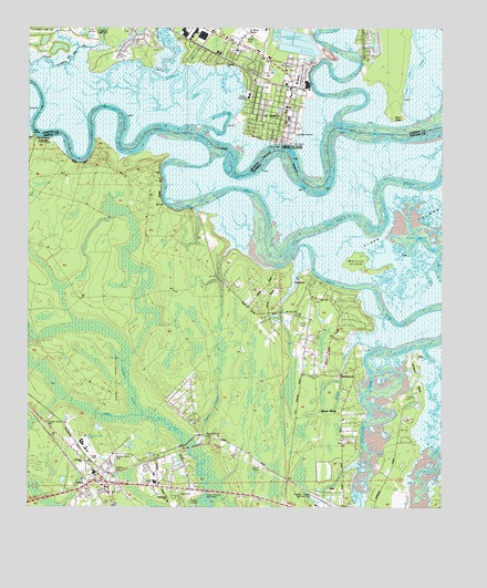
Saint Marys, GA USGS Topographic Map
Click on map above to begin viewing in our Map Viewer.

This topographic map contains these locations and features:
Feature Name Type Latitude Longitude GNIS ID View Map
Blounts BranchStreamN30.6411°W81.5743°279005View Map
Bryant AcademySchoolN30.6319°W81.5868°279533View Map
Burrells CreekStreamN30.7241°W81.5701°312072View Map
ChesterPopulated PlaceN30.6830°W81.5401°280372View Map
Chester Missionary ChurchChurchN30.6800°W81.5373°280373View Map
Christ Episcopal ChurchChurchN30.7238°W81.5491°2502239View Map
Church of Our Savior (historical)ChurchN30.7325°W81.5470°1671332View Map
Coastal Baptist ChurchChurchN30.7444°W81.5601°2502240View Map
CrandallPopulated PlaceN30.7211°W81.6220°295224View Map
Cypress Lake EstatesPopulated PlaceN30.7477°W81.5220°1671334View Map
Dark Entry CreekStreamN30.7377°W81.5854°313309View Map
Devils ElbowBendN30.7297°W81.6015°1704984View Map
Evangelical Temple Assembly of God ChurchChurchN30.7347°W81.5570°2502241View Map
First Baptist Church of Saint MarysChurchN30.7250°W81.5462°1671344View Map
First Presbyterian ChurchChurchN30.7252°W81.5480°2502242View Map
GlenwoodPopulated PlaceN30.6611°W81.5268°294787View Map
Goodbread Mobile Home ParkPopulated PlaceN30.6485°W81.6184°2452873View Map
Higginbotham CemeteryCemeteryN30.6433°W81.5704°283988View Map
Johnson NeckCapeN30.6588°W81.5076°284884View Map
Lands EndPopulated PlaceN30.7400°W81.5215°1671376View Map
Martins IslandIslandN30.6894°W81.5257°286476View Map
McQueen CreekStreamN30.6511°W81.5923°286653View Map
Millers BluffCliffN30.7416°W81.5240°1671393View Map
Millers BranchStreamN30.7372°W81.6245°318272View Map
Mount Zion ChurchChurchN30.6758°W81.5440°287361View Map
Nassau Acres Mobile Home ParkPopulated PlaceN30.6378°W81.5989°2452872View Map
Nassau AirportAirportN30.6266°W81.5342°309399View Map
Nassau County Criminal CourtBuildingN30.6257°W81.5378°2333107View Map
Nassau County Fire and Rescue Service HeadquartersBuildingN30.6267°W81.5363°2644385View Map
Nassau County Fire and Rescue Station 30BuildingN30.6337°W81.6041°2644016View Map
National Park Service Cumberland Island National Seashore Ranger StationBuildingN30.7203°W81.5498°2734096View Map
New Hope ChurchChurchN30.6741°W81.5407°287638View Map
New Town Plantation (historical)LocaleN30.7272°W81.5129°1671396View Map
North RiverStreamN30.7266°W81.5320°319670View Map
Oak Grove CemeteryCemeteryN30.7233°W81.5540°319741View Map
Osprey Cove Golf and Country ClubLocaleN30.7493°W81.6167°2502683View Map
Our Lady Star of the Sea Catholic ChurchChurchN30.7255°W81.5462°1671402View Map
Peter Point LandingLocaleN30.7441°W81.5215°1671406View Map
Point PeterCapeN30.7266°W81.5151°356478View Map
Point Peter CreekStreamN30.7272°W81.5081°320964View Map
Reids BluffCliffN30.7147°W81.6087°289633View Map
RiverviewPopulated PlaceN30.7452°W81.5759°1671416View Map
Roses BluffCliffN30.7091°W81.5851°289978View Map
Saint Mary's Elementary SchoolSchoolN30.7269°W81.5465°1671419View Map
Saint MarysPopulated PlaceN30.7305°W81.5465°356510View Map
Saint Marys City HallBuildingN30.7259°W81.5472°2502438View Map
Saint Marys Fire Department Station 2BuildingN30.7482°W81.5601°2603931View Map
Saint Marys Historic DistrictParkN30.7219°W81.5498°1671420View Map
Saint Marys Police DepartmentBuildingN30.7496°W81.5530°2502316View Map
Saint Marys Public LibraryBuildingN30.7414°W81.5527°2502413View Map
Saint Marys Water Pollution Control PlantLocaleN30.7227°W81.5434°2502465View Map
ShadowlandPopulated PlaceN30.7461°W81.5873°1671421View Map
St Marys AirportAirportN30.7486°W81.5588°351891View Map
Tiger IslandIslandN30.6975°W81.5120°294322View Map
Vaughn LandingLocaleN30.6283°W81.5732°295684View Map
Victory Baptist ChurchChurchN30.7457°W81.5634°2502244View Map
YuleePopulated PlaceN30.6319°W81.6065°293610View Map
Yulee CemeteryCemeteryN30.6350°W81.5995°293611View Map
Yulee Census Designated PlaceCensusN30.6350°W81.5678°2403048View Map
Yulee DivisionCivilN30.6477°W81.6164°1935981View Map
Yulee Elementary SchoolSchoolN30.6317°W81.5860°298345View Map
Yulee Post OfficePost OfficeN30.6310°W81.6083°2768059View Map
Yulee Volunteer Fire DepartmentBuildingN30.6362°W81.6036°2644200View Map
Yulee Volunteer Fire Department Station 3BBuildingN30.6730°W81.5305°2644684View Map

Note: Coordinates in the location and feature list above are referenced to NAD83 datum.


Copyright (C) 2008-2024 Ryan Niemi / Sunset Dynamics ... All Rights Reserved