TopoQuest Logo
Do you find TopoQuest useful?
Help keep TopoQuest running and adding new maps/features by donating!
Bitcoin:  19c7KJd3qBynnjoSw5npx9KScwjBe4ifkT
Litecoin:  LXs6TkuXGGXo1vDsWCkWVdjQX94eUKd6ui
Home View Maps Find Maps Find Places Resources & Links


Chillicothe, Iowa Topographic Map

USGS Map Title: Chillicothe, IA
USGS Map MRC: 41092A5
DRG (GeoTIFF) Download: o41092a5.tif


Neighboring USGS Topographic Map Quads:


  Eddyville, IA  
41092B6
 

  Kirkville, IA  
41092B5
 

  Fremont, IA  
41092B4
 

  Avery, IA  
41092A6
 

  Chillicothe, IA  
41092A5
 

  Ottumwa North, IA  
41092A4
 

  Blakesburg, IA  
40092H6
 

  Blakesburg NE, IA  
40092H5
 

  Ottumwa South, IA  
40092H4


Map MRC Location:

N42°
W93°
N42°
W92°
H8 H7 H6 H5 H4 H3 H2 H1
G8 G7 G6 G5 G4 G3 G2 G1
F8 F7 F6 F5 F4 F3 F2 F1
E8 E7 E6 E5 E4 E3 E2 E1
D8 D7 D6 D5 D4 D3 D2 D1
C8 C7 C6 C5 C4 C3 C2 C1
B8 B7 B6 B5 B4 B3 B2 B1
A8 A7 A6 A5 A4 A3 A2 A1
N41°
W93°
N41°
W92°

Chillicothe, IA USGS 1:24K Topographic Map Preview:
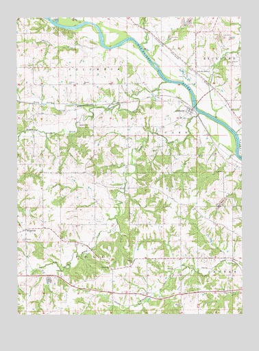
Chillicothe, IA USGS Topographic Map
Click on map above to begin viewing in our Map Viewer.

This topographic map contains these locations and features:
Feature Name Type Latitude Longitude GNIS ID View Map
BidwellPopulated PlaceN41.0189°W92.5385°464463View Map
BidwellLocaleN41.0189°W92.5385°1975409View Map
Bidwell Post Office (historical)Post OfficeN41.0189°W92.5385°1975408View Map
Bowen CemeteryCemeteryN41.0417°W92.5335°1975632View Map
Brooks CemeteryCemeteryN41.0037°W92.5341°454845View Map
Brown CreekStreamN41.1225°W92.5894°454861View Map
ChillicothePopulated PlaceN41.0856°W92.5294°455394View Map
ChillicotheLocaleN41.0872°W92.5280°1975560View Map
Chillicothe CemeteryCemeteryN41.0892°W92.5335°1975635View Map
Chillicothe First RespondersBuildingN41.0854°W92.5298°2599960View Map
Chillicothe Post OfficePost OfficeN41.0856°W92.5294°1975559View Map
Chisman CemeteryCemeteryN41.0229°W92.5613°455398View Map
Christianburg ChurchChurchN41.0197°W92.5741°455406View Map
Christiansburgh Post Office (historical)Post OfficeN41.0153°W92.5724°1975405View Map
City of ChillicotheCivilN41.0860°W92.5303°2393516View Map
Columbia CemeteryCemeteryN41.0972°W92.5963°455542View Map
Columbia ChurchChurchN41.0972°W92.5877°455543View Map
Comstock CemeteryCemeteryN41.0972°W92.5224°1975606View Map
Comstock CreekStreamN41.0831°W92.5163°455557View Map
Comstock Post Office (historical)Post OfficeN41.0961°W92.5163°466549View Map
Comstock Station (historical)LocaleN41.0961°W92.5163°465471View Map
DudleyPopulated PlaceN41.0878°W92.5919°464522View Map
Dudley Post Office (historical)Post OfficeN41.0889°W92.5169°466548View Map
Folgman CemeteryCemeteryN41.0250°W92.6085°1975630View Map
Fountain Springs Post Office (historical)Post OfficeN41.1028°W92.5266°1975404View Map
Fudge CreekStreamN41.1131°W92.5560°456799View Map
Griffith CemeteryCemeteryN41.1111°W92.5169°1975602View Map
Happy Hollow (historical)LocaleN41.0633°W92.5030°1975407View Map
Happy Hollow Post Office (historical)Post OfficeN41.0633°W92.5030°1975406View Map
Kirkville StationLocaleN41.1017°W92.5255°458109View Map
Little Chisman CemeteryCemeteryN41.0309°W92.6208°458454View Map
McNeese Wildlife AreaParkN41.0953°W92.5460°1975386View Map
Middle Avery CreekStreamN41.0978°W92.5410°459024View Map
MuntervillePopulated PlaceN41.0356°W92.6202°459403View Map
Munterville CemeteryCemeteryN41.0363°W92.6193°1975634View Map
Munterville Lutheran ChurchChurchN41.0361°W92.6199°1975567View Map
Munterville Post Office (historical)Post OfficeN41.0370°W92.6171°466550View Map
Myrick CemeteryCemeteryN41.0833°W92.5335°1975629View Map
North Avery CreekStreamN41.0872°W92.5813°459551View Map
Palestine CreekStreamN41.1145°W92.5782°459995View Map
Sand Stone (historical)LocaleN41.0961°W92.5163°465476View Map
Shocks Post Office (historical)Post OfficeN41.0656°W92.5019°467223View Map
Shocks Station (historical)LocaleN41.0656°W92.5019°465472View Map
Smith CemeteryCemeteryN41.0303°W92.5930°461683View Map
South Avery CreekStreamN41.0845°W92.5232°461759View Map
Township of CassCivilN41.0728°W92.5416°467546View Map
Township of ColumbiaCivilN41.1230°W92.5875°467643View Map
Township of PolkCivilN41.0263°W92.5847°468559View Map
West Gate Rest AreaParkN41.0089°W92.5030°462860View Map
WillardPopulated PlaceN41.0061°W92.5896°464307View Map
Willard (historical)LocaleN41.0061°W92.5896°1975390View Map
Willard Post Office (historical)Post OfficeN41.0061°W92.5896°1975389View Map
Williams CemeteryCemeteryN41.0945°W92.5169°1975601View Map

Note: Coordinates in the location and feature list above are referenced to NAD83 datum.


Copyright (C) 2008-2025 Ryan Niemi / Sunset Dynamics ... All Rights Reserved