TopoQuest Logo
Do you find TopoQuest useful?
Help keep TopoQuest running and adding new maps/features by donating!
Bitcoin:  19c7KJd3qBynnjoSw5npx9KScwjBe4ifkT
Litecoin:  LXs6TkuXGGXo1vDsWCkWVdjQX94eUKd6ui
Home View Maps Find Maps Find Places Resources & Links


Chino Valley North, Arizona Topographic Map

USGS Map Title: Chino Valley North, AZ
USGS Map MRC: 34112G4
DRG (GeoTIFF) Download: o34112g4.tif


Neighboring USGS Topographic Map Quads:


  Wineglass Ranch, AZ  
34112H5
 

  Paulden, AZ  
34112H4
 

  Hell Point, AZ  
34112H3
 

  Sullivan Buttes, AZ  
34112G5
 

  Chino Valley North, AZ  
34112G4
 

  King Canyon, AZ  
34112G3
 

  Jerome Canyon, AZ  
34112F5
 

  Chino Valley South, AZ  
34112F4
 

  Prescott Valley North, AZ  
34112F3


Map MRC Location:

N35°
W113°
N35°
W112°
H8 H7 H6 H5 H4 H3 H2 H1
G8 G7 G6 G5 G4 G3 G2 G1
F8 F7 F6 F5 F4 F3 F2 F1
E8 E7 E6 E5 E4 E3 E2 E1
D8 D7 D6 D5 D4 D3 D2 D1
C8 C7 C6 C5 C4 C3 C2 C1
B8 B7 B6 B5 B4 B3 B2 B1
A8 A7 A6 A5 A4 A3 A2 A1
N34°
W113°
N34°
W112°

Chino Valley North, AZ USGS 1:24K Topographic Map Preview:
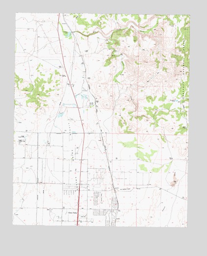
Chino Valley North, AZ USGS Topographic Map
Click on map above to begin viewing in our Map Viewer.

This topographic map contains these locations and features:
Feature Name Type Latitude Longitude GNIS ID View Map
Arizona Highway Maintenance Chino Valley YardLocaleN34.7714°W112.4529°43410View Map
Bible Baptist ChurchChurchN34.7886°W112.4514°2670643View Map
Big Chino ValleyValleyN34.8389°W112.4507°26252View Map
Boundary TankReservoirN34.8245°W112.3847°26664View Map
Chino ValleyPopulated PlaceN34.7575°W112.4538°27601View Map
Chino Valley Community ChurchChurchN34.7743°W112.4524°2670727View Map
Chino Valley District Ranger OfficeLocaleN34.7597°W112.4521°41013View Map
Chino Valley Fire District Station 61BuildingN34.7742°W112.4680°2672471View Map
Chino Valley Police DepartmentBuildingN34.7737°W112.4667°2672257View Map
Chino Valley Post OfficePost OfficeN34.7593°W112.4526°44880View Map
Chino Valley Public LibraryBuildingN34.7737°W112.4657°2669402View Map
Chino Valley Word of Life Assembly of GodChurchN34.7536°W112.4613°2670729View Map
Copper Railroad StationBuildingN34.7753°W112.4291°38367View Map
Country West Mobile Home ParkPopulated PlaceN34.7571°W112.4514°2670387View Map
Del RioPopulated PlaceN34.8231°W112.4435°42737View Map
Del Rio DamDamN34.8209°W112.4649°38405View Map
Del Rio Elementary SchoolSchoolN34.7613°W112.4663°2543718View Map
Del Rio Railroad StationBuildingN34.8492°W112.4524°38406View Map
Del Rio RanchLocaleN34.8303°W112.4502°28408View Map
Del Rio SpringsSpringN34.8209°W112.4452°28409View Map
Duck TankReservoirN34.8084°W112.3775°28655View Map
Excel Education Centers - Chino ValleySchoolN34.7738°W112.4647°2543688View Map
First Southern Baptist Church of Chino ValleyChurchN34.7678°W112.4539°2671011View Map
Granite CreekStreamN34.8628°W112.4318°29474View Map
Heritage Middle SchoolSchoolN34.7630°W112.4666°2543613View Map
Hope Evangelical Lutheran ChurchChurchN34.7604°W112.4476°2671148View Map
Kingdom Hall of Jehovahs WitnessesChurchN34.7927°W112.4522°2671499View Map
Little Chino ValleyValleyN34.8389°W112.4507°31048View Map
Mingus Springs Charter SchoolSchoolN34.7994°W112.4931°2543530View Map
Morgan Ranch and HeadquartersLocaleN34.8609°W112.4416°41012View Map
Puro Railroad StationBuildingN34.8375°W112.4424°38730View Map
Roadrunner Mobile Home ParkPopulated PlaceN34.7556°W112.4502°2670290View Map
Saint Catherine Laboure CatholicChurchN34.7760°W112.4538°2671272View Map
Sullivan DamDamN34.8634°W112.4607°38850View Map
Sullivan LakeReservoirN34.8625°W112.4625°34932View Map
Territorial Early Childhood Center SchoolSchoolN34.7657°W112.4458°2543516View Map
Town of Chino ValleyCivilN34.7593°W112.4107°2413199View Map
Yavapai College Agribusiness and Science Technology CenterSchoolN34.7865°W112.4132°2543492View Map

Note: Coordinates in the location and feature list above are referenced to NAD83 datum.


Copyright (C) 2008-2024 Ryan Niemi / Sunset Dynamics ... All Rights Reserved