TopoQuest Logo
Do you find TopoQuest useful?
Help keep TopoQuest running and adding new maps/features by donating!
Bitcoin:  19c7KJd3qBynnjoSw5npx9KScwjBe4ifkT
Litecoin:  LXs6TkuXGGXo1vDsWCkWVdjQX94eUKd6ui
Home View Maps Find Maps Find Places Resources & Links


Jerome Canyon, Arizona Topographic Map

USGS Map Title: Jerome Canyon, AZ
USGS Map MRC: 34112F5
DRG (GeoTIFF) Download: o34112f5.tif


Neighboring USGS Topographic Map Quads:


  Simmons, AZ  
34112G6
 

  Sullivan Buttes, AZ  
34112G5
 

  Chino Valley North, AZ  
34112G4
 

  Mount Josh, AZ  
34112F6
 

  Jerome Canyon, AZ  
34112F5
 

  Chino Valley South, AZ  
34112F4
 

  Skull Valley, AZ  
34112E6
 

  Iron Springs, AZ  
34112E5
 

  Prescott, AZ  
34112E4


Map MRC Location:

N35°
W113°
N35°
W112°
H8 H7 H6 H5 H4 H3 H2 H1
G8 G7 G6 G5 G4 G3 G2 G1
F8 F7 F6 F5 F4 F3 F2 F1
E8 E7 E6 E5 E4 E3 E2 E1
D8 D7 D6 D5 D4 D3 D2 D1
C8 C7 C6 C5 C4 C3 C2 C1
B8 B7 B6 B5 B4 B3 B2 B1
A8 A7 A6 A5 A4 A3 A2 A1
N34°
W113°
N34°
W112°

Jerome Canyon, AZ USGS 1:24K Topographic Map Preview:
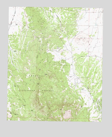
Jerome Canyon, AZ USGS Topographic Map
Click on map above to begin viewing in our Map Viewer.

This topographic map contains these locations and features:
Feature Name Type Latitude Longitude GNIS ID View Map
Alkali SpringSpringN34.6256°W112.5718°21151View Map
American RanchLocaleN34.6739°W112.5441°629View Map
Baker SpringSpringN34.6660°W112.5866°966View Map
Blair PassGapN34.6281°W112.5732°1662View Map
Cedar SpringSpringN34.6360°W112.5941°2649View Map
Central Yavapai Fire District Station 57BuildingN34.6898°W112.5384°2672459View Map
Chimbley TankReservoirN34.6345°W112.5185°40977View Map
Goat CampLocaleN34.6295°W112.6152°44704View Map
Granite MountainSummitN34.6407°W112.5766°25343View Map
Granite Mountain SpringSpringN34.6453°W112.5902°40970View Map
Granite Mountain WildernessReserveN34.6463°W112.5691°41317View Map
Jerome CanyonValleyN34.7111°W112.5818°6398View Map
Lon Stringfield RanchLocaleN34.6284°W112.5118°2040029View Map
MintPopulated PlaceN34.7028°W112.5724°38637View Map
Mint SpringSpringN34.6412°W112.5264°8117View Map
Mint Wash WatersSpringN34.6570°W112.5385°40976View Map
Red HillSummitN34.6347°W112.6116°10049View Map
Red Hill TankReservoirN34.6414°W112.6051°10055View Map
Seep SpringSpringN34.6864°W112.5866°40971View Map
Sheep Canyon SpringSpringN34.6316°W112.6161°11175View Map
Sheep SpringSpringN34.6337°W112.6199°11192View Map
Shroder TankReservoirN34.6627°W112.6170°11261View Map
StringfieldPopulated PlaceN34.6950°W112.5566°38848View Map
Stringfield RanchLocaleN34.6947°W112.5552°40972View Map
Stringfield TankReservoirN34.6596°W112.5281°44648View Map
Stringfield TankReservoirN34.7004°W112.6181°25437View Map
Table MountainSummitN34.7150°W112.5332°12109View Map
Tin Trough SpringSpringN34.6761°W112.5729°12482View Map
White Rock SpringSpringN34.6256°W112.5891°21496View Map
WilliamsonPopulated PlaceN34.6900°W112.5410°1875794View Map
Williamson Census Designated PlaceCensusN34.7082°W112.5342°2409597View Map
Yavapai County Sheriff's Office Williamson ValleyBuildingN34.6898°W112.5383°2751588View Map

Note: Coordinates in the location and feature list above are referenced to NAD83 datum.


Copyright (C) 2008-2024 Ryan Niemi / Sunset Dynamics ... All Rights Reserved