TopoQuest Logo
Do you find TopoQuest useful?
Help keep TopoQuest running and adding new maps/features by donating!
Bitcoin:  19c7KJd3qBynnjoSw5npx9KScwjBe4ifkT
Litecoin:  LXs6TkuXGGXo1vDsWCkWVdjQX94eUKd6ui
Home View Maps Find Maps Find Places Resources & Links


Chippewa Bay, New York Topographic Map

USGS Map Title: Chippewa Bay, NY
USGS Map MRC: 44075D7
DRG (GeoTIFF) Download: o44075d7.tif


Neighboring USGS Topographic Map Quads:


  Morristown, NY  
44075E6


  Chippewa Bay, NY  
44075D7
 

  Hammond, NY  
44075D6
 

  Alexandria Bay, NY  
44075C8
 

  Redwood, NY  
44075C7
 

  Muskellunge Lake, NY  
44075C6


Map MRC Location:

N45°
W76°
N45°
W75°
H8 H7 H6 H5 H4 H3 H2 H1
G8 G7 G6 G5 G4 G3 G2 G1
F8 F7 F6 F5 F4 F3 F2 F1
E8 E7 E6 E5 E4 E3 E2 E1
D8 D7 D6 D5 D4 D3 D2 D1
C8 C7 C6 C5 C4 C3 C2 C1
B8 B7 B6 B5 B4 B3 B2 B1
A8 A7 A6 A5 A4 A3 A2 A1
N44°
W76°
N44°
W75°

Chippewa Bay, NY USGS 1:24K Topographic Map Preview:
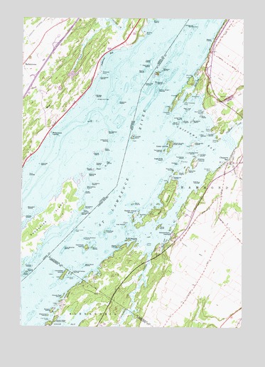
Chippewa Bay, NY USGS Topographic Map
Click on map above to begin viewing in our Map Viewer.

This topographic map contains these locations and features:
Feature Name Type Latitude Longitude GNIS ID View Map
Allens PointCapeN44.4551°W75.7680°975893View Map
Angel IsleIslandN44.4048°W75.8230°974287View Map
Atlantis IslandIslandN44.4423°W75.7769°975906View Map
Big IslandIslandN44.4784°W75.7980°975966View Map
Bilberry IslandIslandN44.4798°W75.7955°975971View Map
Black Rock IslandIslandN44.4001°W75.8394°975985View Map
Blind BayBayN44.4744°W75.7767°975989View Map
Bluff IslandIslandN44.4578°W75.7872°975996View Map
Brush IslandIslandN44.4378°W75.7872°976044View Map
Cedar IslandIslandN44.4487°W75.7905°975830View Map
Cedar Island ShoalBarN44.4598°W75.8039°975832View Map
Cedar Island State ParkParkN44.4495°W75.7905°976095View Map
Cedar IslandsIslandN44.4467°W75.7913°976096View Map
Chippewa BayBayN44.4506°W75.7719°976130View Map
Chippewa BayPopulated PlaceN44.4420°W75.7569°976131View Map
Chippewa CreekStreamN44.4539°W75.7575°976132View Map
Chippewa PointLocaleN44.4645°W75.7936°975826View Map
Chippewa PointCapeN44.4628°W75.7919°976133View Map
Chippewa Yacht ClubLocaleN44.4423°W75.7616°975837View Map
Chokecherry IslandIslandN44.4459°W75.7813°976135View Map
Clouds Rest IslandIslandN44.3876°W75.8511°946913View Map
Crooked CreekStreamN44.4053°W75.8016°976206View Map
Crossover IslandIslandN44.4967°W75.7789°976208View Map
Daney PointCapeN44.4506°W75.7644°976220View Map
Dark IslandIslandN44.4523°W75.8122°976508View Map
Dark Island ShoalBarN44.4592°W75.8094°975833View Map
Denmor FarmsLocaleN44.4036°W75.7689°2702622View Map
Diamond IslandIslandN44.3798°W75.8597°948413View Map
Duck CoveBayN44.4092°W75.7941°976262View Map
Eagle Wing IslandIslandN44.4428°W75.7950°976266View Map
East IronsidesIslandN44.3964°W75.8458°977560View Map
Elm Tree IslandIslandN44.4628°W75.7819°976294View Map
Fire Rock IslandIslandN44.3951°W75.8450°950089View Map
Garden IslandIslandN44.4531°W75.7700°976339View Map
Grants IslandIslandN44.4337°W75.7744°976357View Map
Halfway IslandIslandN44.4139°W75.8272°976395View Map
Halfway Island ShoalBarN44.4126°W75.8305°975829View Map
Hemlock IslandIslandN44.4073°W75.8383°976428View Map
Indian Chief IslandsIslandN44.4714°W75.7983°976466View Map
Indian Chief ShoalBarN44.4678°W75.8069°975827View Map
Indian PointCapeN44.4087°W75.8041°976471View Map
Inner Ironsides ShoalBarN44.3964°W75.8575°973736View Map
Iron IslandsIslandN44.4523°W75.7747°976476View Map
Ironsides IslandIslandN44.3970°W75.8500°976479View Map
Ironsides ShoalBarN44.4048°W75.8522°975839View Map
Jug IslandIslandN44.4170°W75.8163°976509View Map
Kring Point State ParkParkN44.3773°W75.8555°954818View Map
Lily BayBayN44.3939°W75.8383°975842View Map
Little Chippewa PointCapeN44.4670°W75.7830°976558View Map
Little Delight IslandIslandN44.3776°W75.8591°955513View Map
Little Hammond PointCapeN44.4626°W75.7727°976561View Map
Little Ironsides IslandsIslandN44.3967°W75.8461°976562View Map
Lone Brother IslandIslandN44.4070°W75.8505°976580View Map
Lone Tree IslandIslandN44.4598°W75.7844°976582View Map
Lower Scow Island ShoalBarN44.4370°W75.8138°975838View Map
Manzanita IslandIslandN44.4495°W75.7780°976620View Map
McPhall ShoalBarN44.4584°W75.7941°975831View Map
Middle IslandIslandN44.4739°W75.7991°976657View Map
Midway ShoalBarN44.4159°W75.8313°975844View Map
Mink IslandIslandN44.4162°W75.7975°976666View Map
Morgan IslandIslandN44.3817°W75.8572°957666View Map
Oak IslandIslandN44.4237°W75.7941°976751View Map
Oliver IslandIslandN44.4584°W75.7838°976769View Map
Owatonna IslandIslandN44.4362°W75.7894°976783View Map
Peach IslandIslandN44.4912°W75.7683°976803View Map
Peary ShoalBarN44.4053°W75.8272°975843View Map
Pine Tree IslandIslandN44.4734°W75.8025°976827View Map
Poverty IslandBarN44.3978°W75.8669°973735View Map
Poverty Island Lower ShoalBarN44.4003°W75.8605°973737View Map
Preston IsleIslandN44.4412°W75.7866°976855View Map
Rabbit IslandIslandN44.4201°W75.8111°976861View Map
Rabbit Island GroupIslandN44.4220°W75.8086°976862View Map
Rabbit Island ShoalBarN44.4212°W75.8247°975828View Map
Ragnavok IslandIslandN44.4397°W75.7828°2710819View Map
Rob Roy IslandIslandN44.4387°W75.7894°976896View Map
Round Island ShoalBarN44.3964°W75.8680°973740View Map
Saint Margarettes IslandIslandN44.4101°W75.8141°976941View Map
Schermerhorn LandingPopulated PlaceN44.4128°W75.7905°976965View Map
School Number 6 (historical)SchoolN44.3928°W75.7753°2106409View Map
Scow IslandIslandN44.4251°W75.8119°976971View Map
Scow Island Inner ShoalBarN44.4281°W75.8172°975836View Map
Scow Island Outer ShoalBarN44.4295°W75.8236°975835View Map
Shambo IslandIslandN44.4201°W75.8072°976983View Map
Sheephead PointCapeN44.4695°W75.7766°976985View Map
Sister IslandIslandN44.4137°W75.8452°975840View Map
Sister Island LightLocaleN44.4142°W75.8444°977000View Map
Slim Island ShoalBarN44.3948°W75.8697°973739View Map
Snake Oil IslandIslandN44.3756°W75.8491°971978View Map
Snakeoil IslandIslandN44.4592°W75.7783°977015View Map
Snipe IslandIslandN44.4070°W75.8350°977017View Map
Snug Harbor IslandIslandN44.4248°W75.7977°975834View Map
Sturgeon PointCapeN44.4387°W75.7683°977079View Map
Superior ShoalBarN44.4626°W75.7944°975825View Map
Temagami IslandsIslandN44.4467°W75.7944°977101View Map
The RockIslandN44.4423°W75.7850°979977View Map
Third Brother IslandIslandN44.4109°W75.8391°977111View Map
Third Brother Island ShoalBarN44.4128°W75.8363°975841View Map
Third Brother Lighthouse (historical)LocaleN44.4117°W75.8411°2106408View Map
Toothpick IslandIslandN44.4439°W75.7822°977128View Map
Twilight IslandIslandN44.4448°W75.7752°977148View Map
Watch IslandIslandN44.4078°W75.8202°977187View Map
Willy IslandIslandN44.4606°W75.7741°977282View Map
Wyanoke IslandIslandN44.4389°W75.7813°977304View Map

Note: Coordinates in the location and feature list above are referenced to NAD83 datum.


Copyright (C) 2008-2024 Ryan Niemi / Sunset Dynamics ... All Rights Reserved