TopoQuest Logo
Do you find TopoQuest useful?
Help keep TopoQuest running and adding new maps/features by donating!
Bitcoin:  19c7KJd3qBynnjoSw5npx9KScwjBe4ifkT
Litecoin:  LXs6TkuXGGXo1vDsWCkWVdjQX94eUKd6ui
Home View Maps Find Maps Find Places Resources & Links


Hammond, New York Topographic Map

USGS Map Title: Hammond, NY
USGS Map MRC: 44075D6
DRG (GeoTIFF) Download: o44075d6.tif


Neighboring USGS Topographic Map Quads:


  Morristown, NY  
44075E6
 

  Edwardsville, NY  
44075E5
 

  Chippewa Bay, NY  
44075D7
 

  Hammond, NY  
44075D6
 

  Pope Mills, NY  
44075D5
 

  Redwood, NY  
44075C7
 

  Muskellunge Lake, NY  
44075C6
 

  Natural Dam, NY  
44075C5


Map MRC Location:

N45°
W76°
N45°
W75°
H8 H7 H6 H5 H4 H3 H2 H1
G8 G7 G6 G5 G4 G3 G2 G1
F8 F7 F6 F5 F4 F3 F2 F1
E8 E7 E6 E5 E4 E3 E2 E1
D8 D7 D6 D5 D4 D3 D2 D1
C8 C7 C6 C5 C4 C3 C2 C1
B8 B7 B6 B5 B4 B3 B2 B1
A8 A7 A6 A5 A4 A3 A2 A1
N44°
W76°
N44°
W75°

Hammond, NY USGS 1:24K Topographic Map Preview:
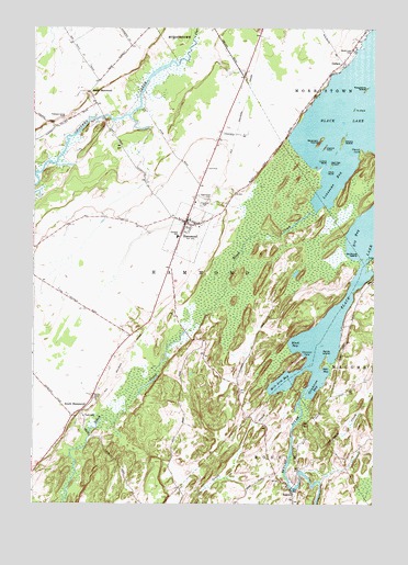
Hammond, NY USGS Topographic Map
Click on map above to begin viewing in our Map Viewer.

This topographic map contains these locations and features:
Feature Name Type Latitude Longitude GNIS ID View Map
Apple IslandIslandN44.4142°W75.6419°975897View Map
Back Bay CampgroundLocaleN44.4142°W75.6537°2599043View Map
Big BayBayN44.4450°W75.6314°975959View Map
Black BayBayN44.4177°W75.6530°975978View Map
Black CreekStreamN44.4520°W75.6463°977213View Map
Black LakeLakeN44.4762°W75.6369°977214View Map
Black Lake (historical)Populated PlaceN44.4706°W75.6586°2106707View Map
Black Lake CemeteryCemeteryN44.4939°W75.6328°975982View Map
Bostwick CreekStreamN44.3973°W75.6516°976004View Map
Bowman IslandIslandN44.4701°W75.6450°976006View Map
Bullhead IslandIslandN44.4403°W75.6311°976057View Map
CedarsPopulated PlaceN44.4912°W75.6366°976100View Map
Central SchoolSchoolN44.4453°W75.6969°976104View Map
Chapman PointCapeN44.4139°W75.6494°976117View Map
Demick FarmsLocaleN44.4558°W75.6925°2702693View Map
Elwood PointCapeN44.4684°W75.6294°976296View Map
Emery IslandIslandN44.4712°W75.6366°976297View Map
Fineview CemeteryCemeteryN44.4534°W75.6886°976310View Map
Grass CreekStreamN44.4051°W75.6583°976359View Map
Grindstone BayBayN44.4059°W75.6467°976381View Map
HammondPopulated PlaceN44.4489°W75.6941°976404View Map
Hammond Airport (historical)AirportN44.4444°W75.6989°2106708View Map
Hammond CemeteryCemeteryN44.4550°W75.6866°976405View Map
Hammond Fire and Rescue DepartmentBuildingN44.4489°W75.6930°2718595View Map
Hammond Free LibraryBuildingN44.4495°W75.6944°2598311View Map
Hammond Post OfficePost OfficeN44.4451°W75.6958°2599004View Map
Herrings Census Designated PlaceCensusN44.4670°W75.6579°2787903View Map
Hogback IslandIslandN44.4689°W75.6427°976445View Map
Indian RiverStreamN44.4062°W75.6491°977230View Map
Jennies IslandIslandN44.4639°W75.6408°976491View Map
Lonesome BayBayN44.4595°W75.6403°976583View Map
Lookout IslandIslandN44.4645°W75.6427°976599View Map
Martin Brothers FarmsLocaleN44.4900°W75.7283°2702695View Map
McLear's Cottage Colony and CampgroundLocaleN44.4834°W75.6450°2599044View Map
Mile Arm BayBayN44.4071°W75.6578°976660View Map
Mitchell FarmsLocaleN44.4625°W75.6881°2702699View Map
North HammondPopulated PlaceN44.4834°W75.7294°976736View Map
OakvalePopulated PlaceN44.3981°W75.7311°976755View Map
Pitcher FarmsLocaleN44.4489°W75.7294°2702690View Map
Pleasant Valley CemeteryCemeteryN44.4758°W75.7393°976837View Map
Rarick CemeteryCemeteryN44.4025°W75.7275°976875View Map
Raspberry IslandIslandN44.4839°W75.6283°976876View Map
RossiePopulated PlaceN44.3787°W75.6549°976909View Map
Sitts BayBayN44.4101°W75.6423°977001View Map
South HammondPopulated PlaceN44.3992°W75.7330°977036View Map
Tavern IslandIslandN44.4395°W75.6277°977098View Map
Town of HammondCivilN44.4352°W75.7398°979040View Map
Village of HammondCivilN44.4464°W75.6935°2390878View Map
Watch IslandIslandN44.4626°W75.6425°977188View Map

Note: Coordinates in the location and feature list above are referenced to NAD83 datum.


Copyright (C) 2008-2024 Ryan Niemi / Sunset Dynamics ... All Rights Reserved