TopoQuest Logo
Do you find TopoQuest useful?
Help keep TopoQuest running and adding new maps/features by donating!
Bitcoin:  19c7KJd3qBynnjoSw5npx9KScwjBe4ifkT
Litecoin:  LXs6TkuXGGXo1vDsWCkWVdjQX94eUKd6ui
Home View Maps Find Maps Find Places Resources & Links


Nesquehoning, Pennsylvania Topographic Map

USGS Map Title: Nesquehoning, PA
USGS Map MRC: 40075G7
DRG (GeoTIFF) Download: o40075g7.tif


Neighboring USGS Topographic Map Quads:


  Hazleton, PA  
40075H8
 

  Weatherly, PA  
40075H7
 

  Christmans, PA  
40075H6
 

  Tamaqua, PA  
40075G8
 

  Nesquehoning, PA  
40075G7
 

  Lehighton, PA  
40075G6
 

  New Ringgold, PA  
40075F8
 

  New Tripoli, PA  
40075F7
 

  Slatedale, PA  
40075F6


Map MRC Location:

N41°
W76°
N41°
W75°
H8 H7 H6 H5 H4 H3 H2 H1
G8 G7 G6 G5 G4 G3 G2 G1
F8 F7 F6 F5 F4 F3 F2 F1
E8 E7 E6 E5 E4 E3 E2 E1
D8 D7 D6 D5 D4 D3 D2 D1
C8 C7 C6 C5 C4 C3 C2 C1
B8 B7 B6 B5 B4 B3 B2 B1
A8 A7 A6 A5 A4 A3 A2 A1
N40°
W76°
N40°
W75°

Nesquehoning, PA USGS 1:24K Topographic Map Preview:
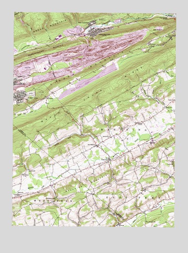
Nesquehoning, PA USGS Topographic Map
Click on map above to begin viewing in our Map Viewer.

This topographic map contains these locations and features:
Feature Name Type Latitude Longitude GNIS ID View Map
AndreasPopulated PlaceN40.7518°W75.7924°1168297View Map
Andreas Post OfficePost OfficeN40.7515°W75.7923°2772573View Map
Bear CreekStreamN40.8256°W75.7680°1168855View Map
Ben Salem ChurchChurchN40.7723°W75.7727°1169224View Map
BloomingdalePopulated PlaceN40.8248°W75.8502°1169853View Map
Bloomingdale ValleyValleyN40.8448°W75.7941°1202467View Map
Borough of NesquehoningCivilN40.8659°W75.8322°1215048View Map
Borough of Summit HillCivilN40.8249°W75.8464°1215051View Map
Broad RunStreamN40.8568°W75.8560°1170293View Map
Broad Run ReservoirReservoirN40.8692°W75.8681°1195120View Map
Cold Spring GroveLocaleN40.7668°W75.8408°1192285View Map
Crooked RunStreamN40.8259°W75.7666°1172727View Map
Deep RunStreamN40.8590°W75.8460°1173074View Map
Dennison RunStreamN40.8526°W75.8702°1173159View Map
Diligence Fire Company District 14BuildingN40.8248°W75.8736°2652765View Map
East Penn AirportAirportN40.7685°W75.7739°1194096View Map
East Penn Township Police DepartmentBuildingN40.7842°W75.7680°2780239View Map
Ginders SchoolSchoolN40.7876°W75.7510°1175630View Map
HackleberniePopulated PlaceN40.8576°W75.7713°1176349View Map
Hell Kitchen GapGapN40.8606°W75.8121°1202465View Map
Hoppers MillPopulated PlaceN40.7826°W75.8635°1203839View Map
Indian MountainSummitN40.8587°W75.8144°1177765View Map
Indian SpringSpringN40.8651°W75.7610°1177788View Map
Jake Arner Memorial AirportAirportN40.8099°W75.7598°1194107View Map
Jeans RunStreamN40.8723°W75.7730°1178000View Map
Lehighton Ambulance Summit Hill StationBuildingN40.8257°W75.8659°2722115View Map
Locust MountainSummitN40.8609°W75.8021°1202249View Map
Mahoning MountainSummitN40.7651°W75.8213°1180225View Map
Mahoning Township Police DepartmentBuildingN40.8118°W75.7723°2780119View Map
Mahoning Valley AmbulanceBuildingN40.7987°W75.8105°2722253View Map
Mahoning Valley Volunteer Fire Company Station 200BuildingN40.7967°W75.8128°2652722View Map
MantzvillePopulated PlaceN40.7679°W75.8699°1204093View Map
Mauch Chunk DamDamN40.8468°W75.7913°1195106View Map
Mauch Chunk LakeReservoirN40.8468°W75.7913°1195107View Map
Mauch Chunk RidgeRidgeN40.8140°W75.8483°1180561View Map
Mertz TownPopulated PlaceN40.8201°W75.7574°1204160View Map
Miller and Rex FarmsLocaleN40.7692°W75.8683°2707291View Map
NesquehoningPopulated PlaceN40.8645°W75.8110°1182268View Map
Nesquehoning 4th Hollow DamDamN40.8684°W75.8663°1195121View Map
Nesquehoning Hose Company District 13BuildingN40.8669°W75.7952°2652948View Map
Nesquehoning JunctionPopulated PlaceN40.8729°W75.7552°1204271View Map
Nesquehoning Police DepartmentBuildingN40.8618°W75.8169°2780268View Map
Nesquehoning Post OfficePost OfficeN40.8631°W75.8161°2772862View Map
New ColumbusPopulated PlaceN40.8684°W75.8152°1193015View Map
New Columbus Fire Company District 13BuildingN40.8701°W75.8160°2653028View Map
New MahoningPopulated PlaceN40.7976°W75.8102°1182349View Map
Normal SquarePopulated PlaceN40.7890°W75.8007°1182502View Map
Oak Grove SchoolSchoolN40.7998°W75.7685°1182756View Map
Our Lady of Mount Carmel CemeteryCemeteryN40.8712°W75.8094°1183120View Map
Pleasant CornersLocaleN40.8106°W75.7794°1184004View Map
Rhume Run GapGapN40.8601°W75.8180°1202468View Map
Saint Johns ChurchChurchN40.8081°W75.7885°1186142View Map
Saint Michaels HomeBuildingN40.7676°W75.8724°1193265View Map
Saint Peters SchoolSchoolN40.7801°W75.8666°1186685View Map
Sanden SchoolSchoolN40.8240°W75.7502°1186934View Map
Stony Mountain SchoolSchoolN40.7537°W75.7716°1188780View Map
Strauss ValleyValleyN40.8025°W75.8121°1188862View Map
Summit HillPopulated PlaceN40.8248°W75.8710°1189044View Map
Summit Hill Police DepartmentBuildingN40.8235°W75.8720°2780109View Map
Summit Hill Post OfficePost OfficeN40.8266°W75.8739°2772995View Map
Township of MahoningCivilN40.8126°W75.7689°1216114View Map
White Bear CreekStreamN40.8176°W75.8566°1191248View Map
WLSH-AM (Lansford)TowerN40.8445°W75.8433°1200460View Map
Zimmerman ChurchChurchN40.8020°W75.8010°1191953View Map

Note: Coordinates in the location and feature list above are referenced to NAD83 datum.


Copyright (C) 2008-2025 Ryan Niemi / Sunset Dynamics ... All Rights Reserved