TopoQuest Logo
Do you find TopoQuest useful?
Help keep TopoQuest running and adding new maps/features by donating!
Bitcoin:  19c7KJd3qBynnjoSw5npx9KScwjBe4ifkT
Litecoin:  LXs6TkuXGGXo1vDsWCkWVdjQX94eUKd6ui
Home View Maps Find Maps Find Places Resources & Links


Chula, Georgia Topographic Map

USGS Map Title: Chula, GA
USGS Map MRC: 31083E5
DRG (GeoTIFF) Download: o31083e5.tif


Neighboring USGS Topographic Map Quads:


  Ashburn, GA  
31083F6
 

  Bethel, GA  
31083F5
 

  Irwinville, GA  
31083F4
 

  Sumner, GA  
31083E6
 

  Chula, GA  
31083E5
 

  Waterloo, GA  
31083E4
 

  Ty Ty, GA  
31083D6
 

  Tifton West, GA  
31083D5
 

  Tifton East, GA  
31083D4


Map MRC Location:

N32°
W84°
N32°
W83°
H8 H7 H6 H5 H4 H3 H2 H1
G8 G7 G6 G5 G4 G3 G2 G1
F8 F7 F6 F5 F4 F3 F2 F1
E8 E7 E6 E5 E4 E3 E2 E1
D8 D7 D6 D5 D4 D3 D2 D1
C8 C7 C6 C5 C4 C3 C2 C1
B8 B7 B6 B5 B4 B3 B2 B1
A8 A7 A6 A5 A4 A3 A2 A1
N31°
W84°
N31°
W83°

Chula, GA USGS 1:24K Topographic Map Preview:
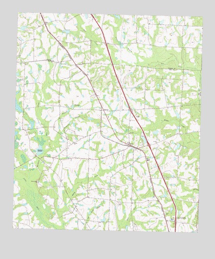
Chula, GA USGS Topographic Map
Click on map above to begin viewing in our Map Viewer.

This topographic map contains these locations and features:
Feature Name Type Latitude Longitude GNIS ID View Map
Allen LakeReservoirN31.5680°W83.5156°341836View Map
Allen Lake DamDamN31.5669°W83.5149°341835View Map
Baker LakeReservoirN31.6162°W83.6210°342121View Map
Baker Lake DamDamN31.6152°W83.6216°342120View Map
Branch LakeReservoirN31.5314°W83.5583°342251View Map
Branch Lake DamDamN31.5302°W83.5582°342250View Map
ChulaPopulated PlaceN31.5496°W83.5474°355165View Map
Chula Baptist ChurchChurchN31.5510°W83.5477°342565View Map
Chula DivisionCivilN31.5479°W83.5557°1936178View Map
Chula Methodist ChurchChurchN31.5505°W83.5482°342566View Map
Cycloneta Church (historical)ChurchN31.5649°W83.5663°342572View Map
Derris Lake Dam Number 1DamN31.5485°W83.5582°340886View Map
Derris Lake Number 1ReservoirN31.5486°W83.5576°340887View Map
Exit 22CrossingN31.5063°W83.5152°1672956View Map
Exit 23CrossingN31.5499°W83.5343°1672957View Map
Exit 24CrossingN31.5702°W83.5474°1672958View Map
Fletcher CemeteryCemeteryN31.5571°W83.5143°342582View Map
Foxhead BranchStreamN31.5563°W83.5949°314338View Map
Friendship ChurchChurchN31.5566°W83.5479°314397View Map
Garrison LakeReservoirN31.5552°W83.5549°341838View Map
Garrison Lake DamDamN31.5552°W83.5549°341837View Map
Gulley BranchStreamN31.5974°W83.5429°314946View Map
Heard CreekStreamN31.5007°W83.5904°356240View Map
Hickory Springs CemeteryCemeteryN31.5268°W83.6088°349374View Map
Hickory Springs ChurchChurchN31.5271°W83.6082°356276View Map
InahaPopulated PlaceN31.6188°W83.6060°326336View Map
Inaha Baptist ChurchChurchN31.6174°W83.6104°343212View Map
Inaha CemeteryCemeteryN31.6196°W83.6124°343213View Map
Jones Lake Dam Number ThreeDamN31.5652°W83.5749°344409View Map
Jones Lake Dam Number TwoDamN31.5652°W83.5699°344407View Map
Jones Lake Number ThreeReservoirN31.5646°W83.5742°344410View Map
Jones Lake Number TwoReservoirN31.5635°W83.5693°344408View Map
Kendrick LakeReservoirN31.6135°W83.5149°342259View Map
Kendrick Lake DamDamN31.6135°W83.5149°342258View Map
Mar-Jan LakeReservoirN31.5878°W83.5681°340889View Map
Mar-Jan Lake DamDamN31.5902°W83.5666°340888View Map
Mount Olive ChurchChurchN31.5519°W83.5291°318734View Map
Mount Zion ChurchChurchN31.5505°W83.5849°318952View Map
Odum LakeReservoirN31.6214°W83.5277°342125View Map
Odum Lake DamDamN31.6202°W83.5282°342124View Map
Saint Johns ChurchChurchN31.5868°W83.5752°342602View Map
Smith CemeteryCemeteryN31.5110°W83.5813°342605View Map
Sumner LakeReservoirN31.6148°W83.5915°342123View Map
Sumner Lake DamDamN31.6135°W83.5899°342122View Map
SunsweetPopulated PlaceN31.5693°W83.5657°356570View Map
Thornbill LakeReservoirN31.5067°W83.5637°341834View Map
Thornbill Lake DamDamN31.5052°W83.5632°341833View Map
Tift County Volunteer Fire Department Station 5BuildingN31.5509°W83.5493°2604742View Map
Tift SchoolSchoolN31.5413°W83.5352°324157View Map
University of Georgia Research LabsSchoolN31.5077°W83.5168°324613View Map
Whiddons Mill CreekStreamN31.5246°W83.6138°325127View Map
Whiddons MillpondReservoirN31.5427°W83.6088°325128View Map
Wiregrass BranchStreamN31.5535°W83.6027°325468View Map
Zion Hill Church (historical)ChurchN31.5080°W83.5982°342629View Map

Note: Coordinates in the location and feature list above are referenced to NAD83 datum.


Copyright (C) 2008-2025 Ryan Niemi / Sunset Dynamics ... All Rights Reserved