TopoQuest Logo
Do you find TopoQuest useful?
Help keep TopoQuest running and adding new maps/features by donating!
Bitcoin:  19c7KJd3qBynnjoSw5npx9KScwjBe4ifkT
Litecoin:  LXs6TkuXGGXo1vDsWCkWVdjQX94eUKd6ui
Home View Maps Find Maps Find Places Resources & Links


Churchland, North Carolina Topographic Map

USGS Map Title: Churchland, NC
USGS Map MRC: 35080G4
DRG (GeoTIFF) Download: o35080g4.tif


Neighboring USGS Topographic Map Quads:


  Mocksville, NC  
35080H5
 

  Advance, NC  
35080H4
 

  Welcome, NC  
35080H3
 

  Cooleemee, NC  
35080G5
 

  Churchland, NC  
35080G4
 

  Lexington West, NC  
35080G3
 

  Rowan Mills, NC  
35080F5
 

  Salisbury, NC  
35080F4
 

  Southmont, NC  
35080F3


Map MRC Location:

N36°
W81°
N36°
W80°
H8 H7 H6 H5 H4 H3 H2 H1
G8 G7 G6 G5 G4 G3 G2 G1
F8 F7 F6 F5 F4 F3 F2 F1
E8 E7 E6 E5 E4 E3 E2 E1
D8 D7 D6 D5 D4 D3 D2 D1
C8 C7 C6 C5 C4 C3 C2 C1
B8 B7 B6 B5 B4 B3 B2 B1
A8 A7 A6 A5 A4 A3 A2 A1
N35°
W81°
N35°
W80°

Churchland, NC USGS 1:24K Topographic Map Preview:
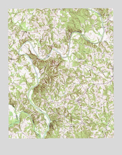
Churchland, NC USGS Topographic Map
Click on map above to begin viewing in our Map Viewer.

This topographic map contains these locations and features:
Feature Name Type Latitude Longitude GNIS ID View Map
Boons Ford (historical)LocaleN35.7782°W80.4612°1018643View Map
Buncomb Baptist ChurchChurchN35.8257°W80.4151°1954395View Map
Cedar Grove ChurchChurchN35.8735°W80.4481°982854View Map
ChurchlandPopulated PlaceN35.7862°W80.4176°983193View Map
Churchland Elementary SchoolSchoolN35.7854°W80.4159°1002029View Map
Churchland Volunteer Fire Department Station 31BuildingN35.7578°W80.4025°2639274View Map
Churchland Volunteer Fire Department Station 32BuildingN35.7892°W80.4145°2639128View Map
Clicks Ferry (historical)CrossingN35.8393°W80.4837°1954396View Map
ClintonPopulated PlaceN35.7568°W80.4601°1008108View Map
Cody CreekStreamN35.8335°W80.4878°983333View Map
Crossroads ChurchChurchN35.8262°W80.4951°983798View Map
Daniel Boone State ParkParkN35.7979°W80.4676°1002035View Map
Davidson County Emergency Medical Services Base 5BuildingN35.8104°W80.3778°2720412View Map
Davidson County Extended Day SchoolSchoolN35.8093°W80.3759°1002037View Map
Dutchman CreekStreamN35.8371°W80.4701°1000745View Map
Dutchmans Creek ChurchChurchN35.8521°W80.4792°984458View Map
Dykers CreekStreamN35.8610°W80.3870°984461View Map
Faith Baptist TabernacleChurchN35.7793°W80.4053°1954320View Map
Farabee CreekStreamN35.7726°W80.4539°985003View Map
Flying M AirportAirportN35.7983°W80.3973°2679211View Map
Forest LakeReservoirN35.8635°W80.3948°999606View Map
Forest Lake DamDamN35.8635°W80.3948°999605View Map
Gobble CreekStreamN35.8435°W80.3892°985752View Map
Grace Baptist ChurchChurchN35.8190°W80.3837°1023467View Map
Grace Baptist SchoolSchoolN35.8190°W80.3837°2025812View Map
Grubb CemeteryCemeteryN35.7704°W80.4131°986181View Map
Hairstons Ferry siteLocaleN35.8482°W80.4101°1008104View Map
Hannas Ferry (historical)LocaleN35.7662°W80.4492°1002057View Map
Hartley CreekStreamN35.8282°W80.4001°986470View Map
Hartleys Ferry siteLocaleN35.8260°W80.4714°1008103View Map
Horseshoe NeckBendN35.8346°W80.4739°987145View Map
Ives Ferry (historical)CrossingN35.8001°W80.4684°1954409View Map
JubileePopulated PlaceN35.7632°W80.4262°1023469View Map
Jubilee AcresPopulated PlaceN35.7610°W80.4153°1002066View Map
Lick RunStreamN35.8282°W80.4370°988459View Map
Martins StorePopulated PlaceN35.8501°W80.4973°1008109View Map
Mill CreekStreamN35.8287°W80.4301°989926View Map
Morrison FieldAirportN35.7817°W80.4169°2679212View Map
No CreekStreamN35.8540°W80.4776°991161View Map
Oak Grove Primitive Baptist ChurchChurchN35.7690°W80.4139°1954356View Map
Oaks Ferry siteLocaleN35.8657°W80.3887°1008105View Map
Peeler CreekStreamN35.8354°W80.4956°992007View Map
PetersvillePopulated PlaceN35.8260°W80.4148°992102View Map
Petersville School (historical)SchoolN35.8254°W80.4117°1954393View Map
Plantation LakeReservoirN35.8585°W80.4131°999590View Map
Plantation Lake DamDamN35.8585°W80.4131°999591View Map
Reedy CreekStreamN35.8001°W80.4709°993191View Map
Saint Johns SchoolSchoolN35.8737°W80.4395°993975View Map
Saint Lukes Lutheran Church (historical)ChurchN35.8171°W80.3756°1954410View Map
Sandy CreekStreamN35.8282°W80.4001°994258View Map
Sandy Creek CemeteryCemeteryN35.8168°W80.3751°994261View Map
Second CreekStreamN35.7660°W80.4878°1000782View Map
Simerson CreekStreamN35.7654°W80.4503°994828View Map
Sowers Ferry siteLocaleN35.7921°W80.4767°1008107View Map
Staley LakeReservoirN35.7718°W80.4081°999398View Map
Staley Lake DamDamN35.7718°W80.4081°999399View Map
Swan CreekStreamN35.7804°W80.4509°995744View Map
Tanyard CreekStreamN35.8074°W80.4648°995842View Map
Township of BooneCivilN35.7608°W80.4020°1026618View Map
Trumps Ferry (historical)LocaleN35.8096°W80.4645°1002115View Map
Tyro Census Designated PlaceCensusN35.7997°W80.3764°2584332View Map
Tyro Rural Fire Department Station 67BuildingN35.8053°W80.3771°2638909View Map
Tyro United Methodist ChurchChurchN35.8076°W80.3756°1954411View Map
Union Chapel SchoolSchoolN35.7612°W80.4259°996443View Map
Yadkin College Baptist ChurchChurchN35.8735°W80.3776°1954366View Map
Yadkin Star Baptist ChurchChurchN35.8679°W80.3781°997679View Map

Note: Coordinates in the location and feature list above are referenced to NAD83 datum.


Copyright (C) 2008-2025 Ryan Niemi / Sunset Dynamics ... All Rights Reserved