TopoQuest Logo
Do you find TopoQuest useful?
Help keep TopoQuest running and adding new maps/features by donating!
Bitcoin:  19c7KJd3qBynnjoSw5npx9KScwjBe4ifkT
Litecoin:  LXs6TkuXGGXo1vDsWCkWVdjQX94eUKd6ui
Home View Maps Find Maps Find Places Resources & Links


Southmont, North Carolina Topographic Map

USGS Map Title: Southmont, NC
USGS Map MRC: 35080F3
DRG (GeoTIFF) Download: o35080f3.tif


Neighboring USGS Topographic Map Quads:


  Churchland, NC  
35080G4
 

  Lexington West, NC  
35080G3
 

  Lexington East, NC  
35080G2
 

  Salisbury, NC  
35080F4
 

  Southmont, NC  
35080F3
 

  Grist Mountain, NC  
35080F2
 

  Rockwell, NC  
35080E4
 

  Gold Hill, NC  
35080E3
 

  High Rock, NC  
35080E2


Map MRC Location:

N36°
W81°
N36°
W80°
H8 H7 H6 H5 H4 H3 H2 H1
G8 G7 G6 G5 G4 G3 G2 G1
F8 F7 F6 F5 F4 F3 F2 F1
E8 E7 E6 E5 E4 E3 E2 E1
D8 D7 D6 D5 D4 D3 D2 D1
C8 C7 C6 C5 C4 C3 C2 C1
B8 B7 B6 B5 B4 B3 B2 B1
A8 A7 A6 A5 A4 A3 A2 A1
N35°
W81°
N35°
W80°

Southmont, NC USGS 1:24K Topographic Map Preview:
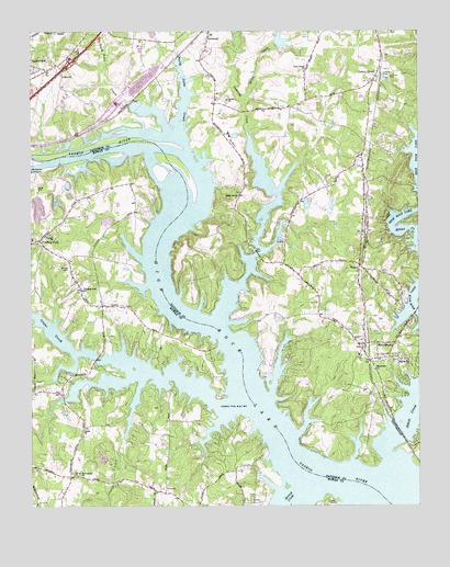
Southmont, NC USGS Topographic Map
Click on map above to begin viewing in our Map Viewer.

This topographic map contains these locations and features:
Feature Name Type Latitude Longitude GNIS ID View Map
Abbotts CreekStreamN35.6287°W80.2634°1023789View Map
Bethel CemeteryCemeteryN35.6879°W80.3626°981103View Map
Buck Ash PondReservoirN35.7118°W80.3631°999280View Map
Buck Ash Pond DamDamN35.7118°W80.3631°999281View Map
Camp SaponaLocaleN35.6271°W80.2792°982550View Map
Church CreekStreamN35.6585°W80.3434°1001107View Map
Clodfelter LakeReservoirN35.6935°W80.2914°999264View Map
Clodfelter Lake DamDamN35.6935°W80.2914°999265View Map
Cobles ReservoirReservoirN35.7478°W80.2941°999347View Map
Cobles Reservoir DamDamN35.7468°W80.2948°999346View Map
Cotton GrovePopulated PlaceN35.7390°W80.2626°1019799View Map
Cotton Grove United Methodist ChurchChurchN35.7368°W80.2645°1954554View Map
Cowans FerryPopulated PlaceN35.7487°W80.3659°1002033View Map
Crane CreekStreamN35.6526°W80.3170°1019847View Map
CravenPopulated PlaceN35.6285°W80.3317°983720View Map
Dan Nicholas LakeReservoirN35.6418°W80.3481°999188View Map
Dan Nicholas Lake DamDamN35.6418°W80.3481°999187View Map
Dan Nicholas ParkParkN35.6413°W80.3448°1001819View Map
FeezorPopulated PlaceN35.6885°W80.2689°1020228View Map
FoxcroffPopulated PlaceN35.7335°W80.2845°1002051View Map
Greers Chapel United Methodist ChurchChurchN35.7454°W80.3595°986135View Map
Hicks Ferry (historical)LocaleN35.6549°W80.2951°1002058View Map
JerseyPopulated PlaceN35.7310°W80.3153°1954555View Map
Jersey Baptist ChurchChurchN35.7321°W80.3117°987580View Map
Jersey CemeteryCemeteryN35.7329°W80.3114°1954549View Map
LakeviewPopulated PlaceN35.7396°W80.3698°988096View Map
Macedonia United Methodist ChurchChurchN35.6610°W80.2642°989189View Map
Millers Ferry Fire DepartmentBuildingN35.6940°W80.3701°2639673View Map
Mountain View EstatesPopulated PlaceN35.7221°W80.2981°1002080View Map
New Jersey African Methodist Episcopal Zion ChurchChurchN35.7396°W80.2867°991048View Map
North Potts CreekStreamN35.7190°W80.3323°991254View Map
Providence ChurchChurchN35.6340°W80.3595°992874View Map
RavenwoodPopulated PlaceN35.7121°W80.3073°1002098View Map
Rising Star ChurchChurchN35.6632°W80.2534°993369View Map
Second CreekStreamN35.6332°W80.2845°994465View Map
Sharp ChurchChurchN35.6457°W80.3576°994597View Map
Smith Grove ChurchChurchN35.7071°W80.3081°994978View Map
Sooky CreekStreamN35.7304°W80.3067°995112View Map
South Potts CreekStreamN35.7240°W80.3314°1022713View Map
SouthmontPopulated PlaceN35.6679°W80.2670°995244View Map
Southmont Census Designated PlaceCensusN35.6536°W80.2702°2628657View Map
Southmont Elementary SchoolSchoolN35.6649°W80.2695°1023475View Map
Southmont First Baptist ChurchChurchN35.6729°W80.2701°1954552View Map
Southmont Post OfficePost OfficeN35.6645°W80.2672°2774359View Map
Southmont Volunteer Fire Department Station 56BuildingN35.6595°W80.2636°2638936View Map
Swearing CreekStreamN35.6743°W80.3148°995772View Map
Township of Cotton GroveCivilN35.7135°W80.2828°1026620View Map
Township of ProvidenceCivilN35.6334°W80.3661°1027150View Map
Trading FordPopulated PlaceN35.6951°W80.3723°996199View Map
Trading Ford (historical)CrossingN35.7210°W80.3359°1954558View Map
Trading Ford ChurchChurchN35.6821°W80.3581°996200View Map
Watership DownsPopulated PlaceN35.6907°W80.3073°1002123View Map
Yadkin ChurchChurchN35.6962°W80.3678°997676View Map
Zion ChurchChurchN35.7385°W80.3645°997775View Map

Note: Coordinates in the location and feature list above are referenced to NAD83 datum.


Copyright (C) 2008-2025 Ryan Niemi / Sunset Dynamics ... All Rights Reserved